
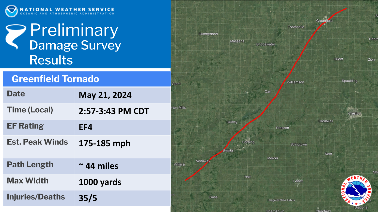
On May 21, 2024, severe thunderstorms struck central Iowa, producing flash flooding, straight line wind damage and at least nine tornadoes. One of those tornadoes impacted the community of Greenfield, resulting in five fatalities. The tornado was rated an EF4 by the NOAA National Weather Service (NWS), with an estimated wind speed of up to 185 miles per hour.
NOAA National Weather Service forecasters issued excellent forecasts and warnings for the storms. Just hours before they occurred, researchers inside the NOAA Hazardous Weather Testbed in Norman, Okla., were using an experimental new tool called Warn-on-Forecast to provide additional information to NWS forecasters. Warn-on-Forecast uses computer models and machine learning to project tornadoes at long lead times.
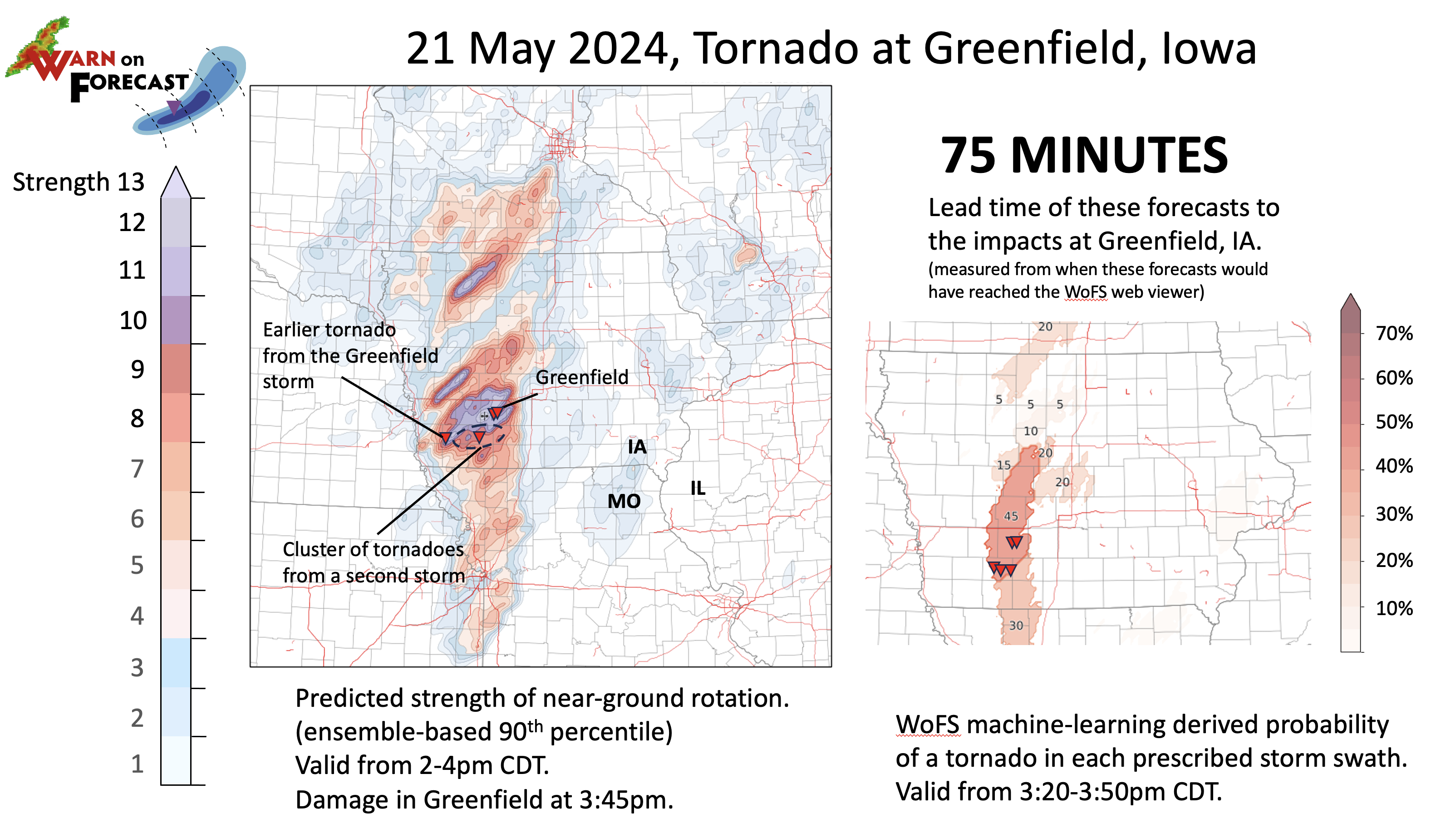
For the Greenfield tornado, Warn-on-Forecast yielded strong confidence in the probability of extremely strong near-ground rotation in the Greenfield area more than an hour before the tornado touched down. These results were shared with NWS forecasters in Iowa to assist in their work issuing warnings.
“Forecasters were discussing these exact signals in the internal chat rooms once they had arrived from Warn-on-Forecast, at about 75 minutes prior to the tornado hitting Greenfield,” said Patrick Burke, NOAA National Severe Storms Laboratory scientist and Warn-on-Forecast Program Lead.
That type of long lead time can give forecasters greater confidence to issue warnings and narrow down the areas most likely to be impacted.
WHAT IS THE WARN-ON-FORECAST SYSTEM?
The Warn-on-Forecast System (WoFS) is a NOAA research project that aims to increase lead time for tornado, severe thunderstorm, and flash flood warnings using numerical weather prediction models.
- WoFS is designed to make probabilistic predictions of individual thunderstorms out to six hours in advance rather than the current method of issuing warnings after storms form and severe hazards are observed.
- The Warn-on-Forecast project harnesses high-resolution numerical weather prediction models and high performance computing.
WHY WoFS?
Meteorologists and their tools are good at identifying which days will see severe weather in different regions, but warnings, which serve as an immediate call to action for specific storms affecting specific locations, are usually issued within minutes of local impacts.
Warnings have traditionally been based on detection or indicators of severe hazards using National Weather Service Doppler radars, and trends in yearly-averaged tornado warning lead time reveal this “warn-on-detection” approach has reached a plateau. WoFS offers a way to provide more notice, and more time to take action.
THE IMPACT
As one of NOAA’s strategic goals, increasing lead time for severe weather warnings is intended to reduce loss of life, injury, and damage to the economy.


