
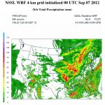
An NSSL microphysics scheme that will help forecast six different types of precipitation more accurately was included in the most recent update of the Weather Research and Forecasting (WRF) model.
Official websites use .gov
A
.gov website belongs to an official government
organization in the United States.
Secure .gov websites use HTTPS
A
lock (
) or https:// means you’ve safely connected to
the .gov website. Share sensitive information only on official,
secure websites.
An NSSL microphysics scheme that will help forecast six different types of precipitation more accurately was included in the most recent update of the Weather Research and Forecasting (WRF) model.
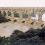
A catastrophic flood event threatened the ancient Roman aqueduct bridge Pont du Gard in southern France in September 2002. The HyMex Experiment could help local officials in the Mediterranean region improve forecasts and warnings of flash floods. (Credit: Cévennes Vivarais Mediterranean Hydro-meteorological Observatory)

NOAA, NASA and the University of Connecticut are representing the United States in the Hydrological Cycle in the Mediterranean Experiment (HyMeX), the largest weather field research project in European history.