
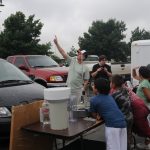
NSSL’s mobile mesonet was on display for the third year at the Apache Tribe Environmental Camp, held annually near Apache or Fort Cobb Okla., about one hour southwest of Oklahoma City.
Official websites use .gov
A
.gov website belongs to an official government
organization in the United States.
Secure .gov websites use HTTPS
A
lock (
) or https:// means you’ve safely connected to
the .gov website. Share sensitive information only on official,
secure websites.
NSSL’s mobile mesonet was on display for the third year at the Apache Tribe Environmental Camp, held annually near Apache or Fort Cobb Okla., about one hour southwest of Oklahoma City.
In May 2012, there were no tornado deaths in the United States. How unusual was that? We can look at the record of tornado deaths, discussed here, dating back to 1875. The last time there…
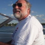
Doug Forsyth, Chief of NSSL’s Radar Research and Development Division is retiring at the end of June. We celebrate Doug’s career and his character by reposting this 2008 spotlight story…”Changes in latitudes…Jimmy Buffett goes south, but Doug Forsyth goes north.”
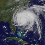
The 2012 Atlantic hurricane season will provide a valuable research opportunity for the Coastal and Inland-Flooding Observation and Warning Project (CI-FLOW).