A Cautionary Note about Deterministic Guidance from High-Resolution NWP Models (A guest post to the U.S. Severe Weather Blog by David Bright).
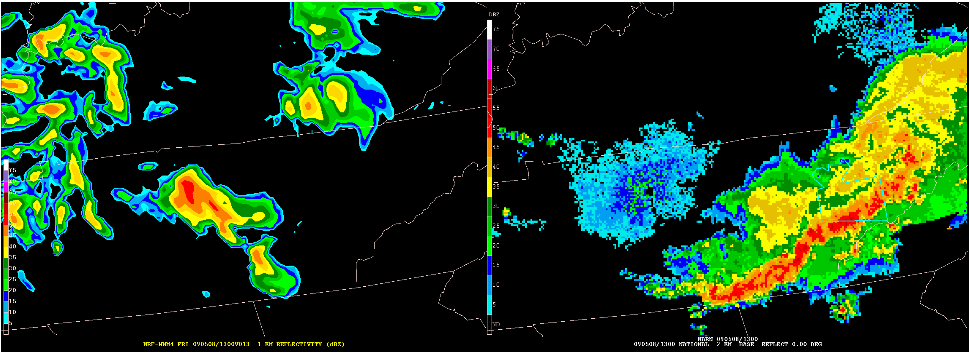
The 13-hour WRF-NMM forecast of the Missouri Bow Echo (see earlier post with this title) is remarkable in both its accuracy and structure, particularly given the severity of the event. As model forecasts go, it appears to be a perfect piece of numerical guidance. But shifting the grid about 450 miles to the east, the exact same 13-hour WRF-NMM completely missed the MCS (albeit less severe) moving through eastern Tennessee. So while there is little doubt that the model provided an essentially perfect prediction of the intense bow echo over southern Missouri, in a purely deterministic sense, the same model provided little-to-no short-term convective guidance with respect to convective mode and QPF over much of Tennessee.
The information provided by these high-resolution NWP models is revolutionary, and will likely lead to a quantum increase in high-impact services provided by the NWS. But let’s be careful not to oversell the capabilities of a single, deterministic model forecast. In order to fully realize the potential of future NWS forecasting and warning services, an ensemble of convective-resolving models will be required to address the uncertainty that accompanies all weather forecasts. The HWT has evaluated convective-resolving models over a large portion of the CONUS for the past several years, and it is encouraging to see the improvements these models have made in high-impact convective guidance and in their ability to predict intense, realistic convective structures such as the bow echo over southern Missouri. But a single high-resolution NWP forecast, regardless of its ability to reproduce intense convective structures, is unlikely to meet the future uncertainty requirements of the entire NWS at all times and locations. That said, the development and evaluation of these convection resolving models is and will continue to be an essential part of future high-impact, life saving, decision support services provided by the NWS, likely realized through a blend of deterministic guidance, well constructed ensemble systems, and related ensemble interrogation tools.
Dr. David Bright, Storm Prediction Center, Science Support Branch, Norman, OK


