STATUS: 26 April 2017

STATUS: IOP

I have been a bit too busy to blog for a while.  Basically, it’s been status quo for VORTEX-SE the last few weeks, with huge forecast difficulties costing us an event last weekend.  We had decided to hold an IOP, but then we cancelled it when the numerical models suggested a very slim chance of tornadoes.  But they were wrong, and there were two interesting supercells in the domain.

Some of our difficulties relate to the fact that we have a domain about eight counties in size.  I don’t think we would ever confine ourselves to eight counties in the Plains, and hope to learn about tornado formation in a domain of that size.  And the best eight counties we’ve found in the Southeast U.S. (northern Alabama) are not very well suited to traditional tornado research.

But we are back at it again.  Tonight, a line of convection will move into AL from the west.  Most of the models are suggesting that this line will weaken as it moves into AL, and pose only a very small tornado threat.  However, the operational HRRR model shows the line breaking up, and then more discrete cells developing within the overall area of convection in northern Alabama.  Some of these are forecast to have rotating updrafts.

The teams are here through Sunday.  So there is no huge cost to operating tonight.  We may also operate on Friday… this should be a high-CAPE day with weaker shear, and little chance of storm initiation.  So if we operate, we will be looking at land use and land cover influences, including lake breezes west of Huntsville.  We will cross our fingers that initiation does occur close to where we are operating.

And Sunday continues to look like a fairly big event, but we have learned that there are a lot of ways for these big waves to fail to be associated with tornadoes.  Sunday will be the last operations day for VORTEX-SE in 2017.

I will likely blog again later this evening as the line of activity moves into our research area.

Tags: None

STATUS: 12 Apr 2017

STATUS: DOWN

VORTEX-SE has been down for the last week.  This is a much-needed break for the researchers, and for me.  Right now, there are no hints of significant severe weather in the Southeast for the next few weeks.  But eventually the current pattern, with weak flow aloft, will probably break down, and VORTEX-SE will conduct its last IOP for 2017.

Last Wednesday was… well…. special.  I think it’s fair to say that the project crews felt that we were finally going to get a data set that included tornadic storms, so the mood in the planning meeting was a lot less gloomy than the last few.  I’m not sure how folks feel after spending a whole day, from dawn to dusk, collecting observations of yet another “failure mode” (YAFM).  If their thoughts are at all like mine, I’m not sure what to hope for in the remainder of this year’s campaign!  I don’t want another significant wave with tornado potential writ large.  Been there, done that.  Repeatedly.  But I don’t want a marginal-looking situation, either.  The next IOP will be our last chance, for a while, to observe Southeast storms with multiple-Dopplers, deployable surface instruments, etc.

It’s been rough.  Most of the project scientists have been involved in field work where the focus is intercepting tornadoes.  Most haven’t really wrapped their heads around how to extract new knowledge from whatever that atmosphere offers up.  And the personal costs are high: missed classes, impacts on student learning, making up lectures, families back home, arranging and rearranging travel and accommodations daily, missions that start at 4 AM, and on and on.

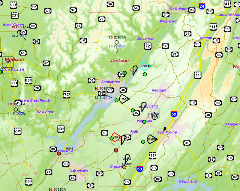
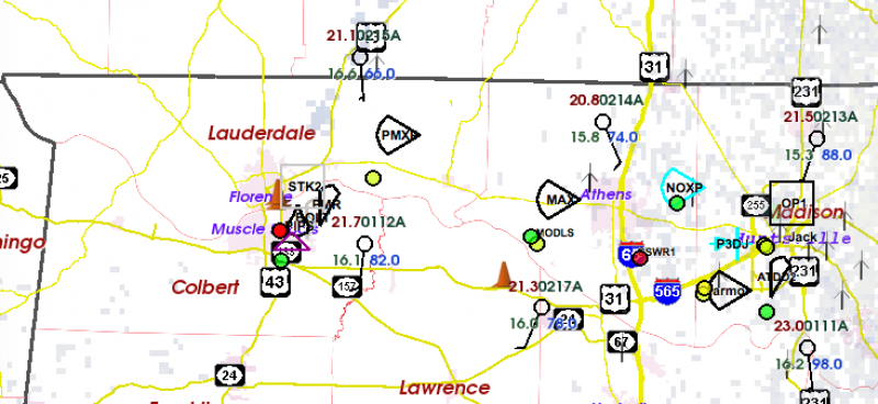
There are mission days when we are pretty sure that there won’t be significant tornadoes even though the lead-up looked promising, and there are a few that do seem to have significant tornado potential.  Last Wednesday was one of the latter.  There was an SPC moderate risk in northern AL, and a high risk further south.  The usual tornado forecast parameters were all in place.  But the activity in northern AL was benign.  The cumulonimbus clouds were fairly vigorous in the lower levels, but in the middle levels they became fuzzy and shredded. Mixing with warm dry air appeared to be evaporating them.  Anvils were never solid-looking, but were puffs of ice drifting away from the updraft.  Was there too much shear?  Too warm and dry aloft?  Not enough focus in the lower levels? Something wrong with the hodograph?

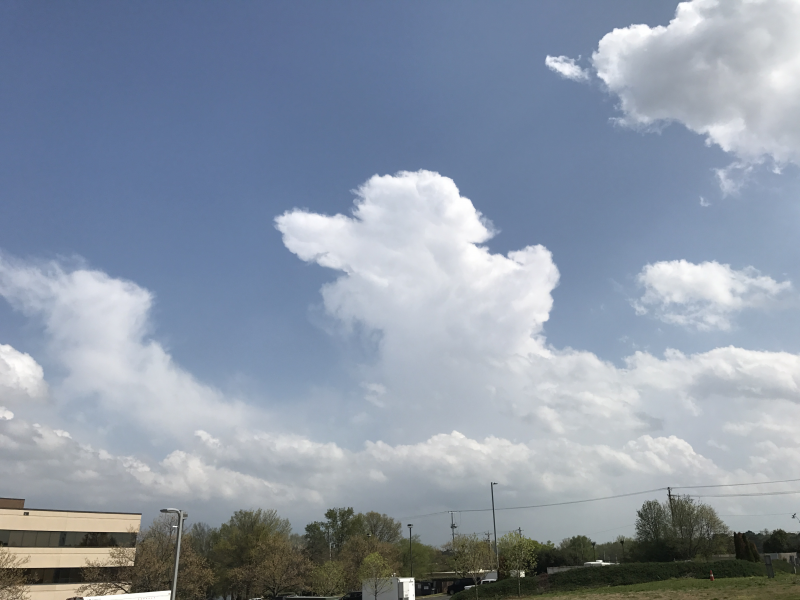
  (looking south-southeast from the SWIRLL facility at U. Alabama-Huntsville)

On radar, the echoes were strung out along the strong upper level flow.  Those few echoes that had any longevity seemed to be moving into these bands of moistened air.  For the most part, the echoes were weak.  And another pathology that I have not seen before:  the echoes had the shape of cyclonically rotating supercells, but many appeared to have anticyclonic wind shear in the Doppler radar data.  The only storm in the domain to produce a research-worthy low-level vortex did not appear to be a supercell on radar, and was perhaps enhanced by terrain effects near Sand Mountain.

I’ve heard a different explanation of this day’s “failure mode” from each meteorologist I’ve talked to.  This is all speculation (OK, OK… informed speculation).  Once we dig into the rich set of soundings obtained by VORTEX-SE, and perhaps do some computer simulations of the overall setup as well as individual “storms”, we can move from speculation to some more solid information.

This is important.  As usual, I believe the forecasters in the NWS forecast offices and the SPC did just about as well as our current understanding allows.  Any forecaster (this blogger included) can look at an event in hindsight and “explain” how the forecast went wrong.  We can satisfy ourselves that our own comprehension of the situation was better than some other forecaster’s.  And the risk here is that our self-confirmed (mis-)understanding of the event becomes the lens through which we look at future events.

But we really have a lot to learn about severe weather forecasting.  We do know that when a significant tornado occurs, it is probably in an environment that features a certain mix of CAPE, deep shear, near-ground shear, etc.  Our climatologies show this.  We have sounding analysis tools based on this understanding.  But our climatologies also show us that when that certain mix of conditions is present, a large percentage of the time there will not be significant tornadoes.  In other words, in these potent-looking environments, most of the time “something” will reduce tornado potential.  In the last 25-30 years we have learned a lot about the conditions present when significant tornadoes happen, but we have learned little about these “somethings” that usually get in the way of tornado production.

It could also be true that our most-used forecast parameters are not the most physically relevant, but instead are only reasonably well-correlated with some yet-to-be-discovered pertinent parameters, so we may be able to improve forecasting by finding more reliable forecast parameters.  I was involved in some of the early research to identify the environmental conditions that are present when significant tornadoes occur.  And I look forward to the day when researchers can show how my early work was off the mark, and the old ideas can be discarded.

Over time, researchers will probably increase their focus on the “failure modes”, and we will learn to recognize the factors that reduce tornado risk.  This may be one of the bigger short-term contributions of VORTEX-SE.  We certainly have a rich palette of observed failure modes to study!

Erik

P.S.  The psychological and social aspects of this event, and VORTEX-SE in general, are worthy of a lot of blogging.  In many ways, they loom a lot larger than the meteorological aspects.  I hope I can convince some of my colleagues and VORTEX-SE researchers to share some of their insights and perceptions in this blog someday soon.

Tags: None

STATUS: 9:30 AM 5 Apr

This map shows where our teams are deployed today.  Elevation ranges about 200 m (darkest green) to above 600 m on Sand Mountain (pale green).  Small color-filled circles are our research deployment sites.  Huntsville AL is on the west edge, so this map covers all of northeast AL.

Sand Mountain is that broad swath of gently rising terrain that extends out of the northeast corner of the state.  The river on the west edge of Sand Mountain is the Tennessee River, flowing southwest until it turns back northwest toward Huntsville.  This area is a good natural laboratory for looking at the influence of terrain features on the small-scale environments of storms, with very rough terrain just northeast of Huntsville, the broadly sloping Sand Mountain plateau, and a similar feature called Lookout Mountain further southeast.  There is a big variety of land use here, including cultivated agriculture, dense forests, large lakes/rivers, and large urban areas.

The first round of storms is moving off into Georgia, and now we await more significant supercells from midday through late afternoon.

Tags: None

STATUS 5 Apr 2017

Operations have begun this morning, with teams hitting the road around 5 AM.  We have just launched about a dozen 12Z soundings across N AL and MS.  Elevated convective cells with a few lightning strikes are moving into the southern part of our domain.  At this time, it is very uncertain how these cells will influence the surface weather map.  They are likely to leave behind a pool of cooled outflow air somewhere across the N 1/2 of AL, and this could be a focus for higher tornado potential later today.

Our teams are deploying to what we call the “eastern domain”, focused on Sand Mountain, a gently-sloping plateau in northeast AL.  We will have a network of 4-5 mobile Dopplers scanning throughout the day in this domain. We are choosing this domain because it has looked like it has the highest probability of tornadic supercells through the day.

It should be a very busy day here in the Ops Center, so I am not sure I will blog again.


Tags: None

STATUS: 4 Apr 2017

I’m still in Huntsville.  My one attempt at getting back to my desk, and my boxer, failed when I flew to OKC (two attempts), and had to drive straight back to Huntsville.

One of the more interesting things I have observed here involves all the misperceptions about VORTEX-SE objectives and decision making.  VORTEX-SE is not all about catching significant tornadoes when the risk is well recognized.  It is much more about tackling all the crazy uncertainties that arise whenever tornado potential exists.  Those readers who understand probability know that tornado potential is very close to zero most days of the year… so close that a forecaster could say “there will not be tornadoes”.  But the biggest forecast problems are when the probabilities are, say, in the few-percent range.  So, in VORTEX-SE we lean heavily toward operating in iffy situations because there is so much to learn, even if no tornado occurs.  When VORTEX-SE operates, it’s not because we are saying “there will be tornadoes”, and disagreeing with NWS and SPC forecasts.  We are operating because we are saying “there is a large enough chance of a tornado that we need to study the way the atmosphere is behaving.”

We don’t define success as the number of tornado deployments vs. the number of null deployments. We define success based on the amount of new knowledge we can generate that improves our understanding of tornado environments, and the predictions of the weather associated with those environments.  No doubt the mood of the researchers sours a lot in these null cases, but by and large we know that we have to be here observing the null cases to have any hope of observing the tornado cases.

Back to the weather.  We deployed yesterday in western AL and watched some micro-supercells move toward the network from MS.  I will probably be skewered in (Anti)Social Media for calling them that, but these cells were persistent, had low-level rotation, and even modest lowerings.  They were only about 15000 feet tall, and didn’t make any cloud-to-ground lightning.  So, scientifically fascinating, but not much of a threat.

Now we turn our attention to tomorrow.  In general, our numerical forecasts suggest a large enough risk for tornadoes in our domain that we must operate.  That’s about the best we can usually say 1-4 days in advance.  VORTEX 94-95, VORTEX-2, and VORTEX-SE have shown us that there are a lot of ways for the atmosphere to bust a tornado forecast, and only a slim chance that all ingredients will really fall into place.  But we will be deployed, and we will be doing everything we can to learn more about the factors that raise or lower tornado potential in otherwise favorable-looking scenarios.

Erik


Tags: None

STATUS: 1 Apr 2017

STATUS: IOP

We just finished a fairly lively discussion of the system that is approaching for early Monday.  It highlighted a lot of the issues we deal with in VORTEX-SE.

Of course, the first thing we try to assess is tornado potential, because if there isn’t at least some potential, there’s not much point to operating.  It looks like there will be very favorable hodographs in our domain on Monday.  The question is: will there be CAPE?  It almost certainly will be low CAPE (< 500 J/kg).  There was a lot of debate about whether potentially buoyant air would move this far north ahead of the early-Monday system, and debate about whether the air mass could recover after this first round and give a second round of storms later in the day.  I think it’s a reasonable hypothesis that tornadoes can occur in nearly zero CAPE as long as the updraft, augmented by the upward forcing associated with very strong environmental wind shear, can extend near the ground.

So after a round of discussion, the researchers generally felt that this is a system we need to look at.

One of the most important items of discussion was a comment made by one of our researchers to the effect of: “Isn’t this exactly what VORTEX-SE is about?  The more uncertain situations, and the low-CAPE high-shear situations?”  In a broad sense, these are exactly the situations we need to target.  The obvious tornado situations are not a big problem in the Southeast… they are well-handled.  So as discouraging as busted deployments can be, and as much as everyone would like to observe a tornadic storm, VORTEX-SE has an overriding obligation to develop knowledge to reduce the uncertainty in situations just like the one we are facing Monday.

And this mix of the role of uncertainty, biases, and recent experiences on decision making has to be pretty interesting to our Social and Behavioral Sciences researchers.  In a broad sense, our whole social sciences emphasis can be boiled down to how humans, from the forecaster all the way to members of the public, make decisions in the face of uncertainty.

Tags: None

STATUS: 31 Mar 2017

I found a few spare minutes to sneak in a blog post!  This one is a bit long-winded, but it’s three days worth, and I’m not very good as a sound bite chef.

It’s hard to describe what VORTEX-SE has been through in the last three days.  In my last post, on Tuesday morning, the researchers had jointly decided that there would be a Gulf Coast convective system on Thursday that had a good chance of spewing chilled/dried air across the domain, and reducing or eliminating tornado chances.  So the researchers from outside of AL all headed back home.

I made it from Huntsville to Dallas/Fort Worth, and then on toward Oklahoma City on a late-night flight.  But weather got in the way, and somewhere east of OKC the flight had to turn back to DFW.  After a few hours in a nearby hotel without my luggage, I headed back to DFW and got on a morning flight to OKC.  When I arrived, my phone was buzzing with text messages that the situation back in Alabama had grown much more concerning.  In fact, I saw this in the sky:

By the time I got to my car in the parking lot at OKC, conditions appeared dire enough that I was told I really needed to get back to Alabama.  No time to grab a rental car, and not trusting the airlines to ensure my arrival, I headed east in my own car on I-40, making it to Memphis in the late evening.   We had a conference with the researchers at 8 PM, I squeezed in a badly needed load of laundry at the hotel, slept about six hours, and then got back on the road early in the morning with one more parking-lot stop to participate in another planning conference call.

You can probably guess the next part of the story.  The forecast had once again become dismal, with the likelihood that the coastal convective system would, indeed, flood the area with air that could not support severe storms.  We worked through every imaginable scenario for supercells, but could not come up with any that had a good probability of occurring.  So instead, we deployed the network of instruments on Sand Mountain, east of Huntsville, to study how that terrain feature modifies the low-level winds and thermal energy in ways that could promote tornadoes, holding out a slim hope that Sand Mountain might actually experience significant storms.

Completely fatigued by the pinball-like travel demands, many of the crews started to head for home early this morning.  But wait… the twisting in the wind continues…

The last few forecast model runs have trended toward a more potent scenario for Alabama for Monday.  So, we have scheduled our next IOP for Monday.  Most teams are making travel arrangements today, and will have until a 10 AM meeting tomorrow to confirm or cancel these plans.

These are the sorts of issues that we face in our tornado research in VORTEX-SE.  The whole research team, and the Scientific Steering Committee of the project, have been doing a lot of thinking and revising of plans over the last 6-9 months.  We will try to reorient our efforts toward observing those things that we can consistently observe over longer periods of time, rather than trying to capture tornadic storms.  We think we can make much bigger, faster progress in the science by looking harder at the environments of all storms in this part of the country, especially those features that span the sizes of 1-100 km (single town to several counties in size), in the lowest 3000 ft.  Tornadoes in the Southeast are hard to predict, hard to “catch”, and even if we got lucky and had a tornado move through one of our deployments, it’s not obvious that we could fully understand the processes related to the tornado, and we sure could not say much generally about tornadoes based on one tornado.

So as time goes on, I expect VORTEX-SE to continue to become more effective at producing new knowledge to improve the forecast/warning of Southeast tornadoes at all lead times, and I have great optimism that we will make big progress in understanding how information about tornadoes is conveyed to the public as well as how people and organizations respond to tornado information.  All of this work will reduce the vulnerability to tornadoes in the Southeast.

Tags: None

STATUS: 28 Mar 2017

STATUS: IOP Watch

After meeting this morning, the researchers decided to not study the system that will pass through AL on Thursday evening.  There were strong hints in several of our forecasting models that there would be a convective system closer to the Gulf Coast with this wave.  In our experience, this tends to mean a loss of low-level moisture and heat in northern AL.  The reasoning was that we now have some very good data sets on storms that appear to have tornado potential, but fail to produce.  Now we need to skip these “marginal” cases when we can trust our own forecasts.

The pattern remains active, with more systems likely to pass through the domain over the next couple of weeks.  We are a bit worried about a possible increase in the strength of the subtropical jet stream over Mexico and the Gulf of Mexico.  This jet often seems to be associated with coastal convection that depletes water vapor before it can move north in our domain.  Just one more fly in the ointment of VORTEX-SE forecasting.

The next system we will be watching is forecast to affect the Southeast around Monday or Tuesday next week.

Yesterday, we had a very good day of observing.  Over 80 soundings were launched from 12 teams, and combined with data from three profiling systems, we should have a detailed picture of the variations across northern AL that may have contributed to the storm behavior and organization.  We also had a well-planned network of five Doppler radars in the area from Huntsville toward Florence.  The NOAA P-3 was in the air from around 3 to 10 PM.  Add to this the storm intercept teams from Texas Tech and Purdue, and we should have comprehensive data on the two systems we studied.

The first was a band of storms, including a few supercells, that developed in far northwest Alabama in the mid-afternoon.  For a short while, some of these rotated intensely enough aloft that they looked capable of being associated with tornadoes.  After this round of storms passed through and out of the domain, a second quasi-linear convective system moved south into the domain from Tennessee.  This second system was observed for several hours, and produced a couple of bow echoes and some reports of severe hail.

Of course the researchers would prefer to study tornadic storms, but a case like this still is important to the research.  We may be able to determine why the storms with rotation aloft didn’t seem to develop rotation very close to the ground.  We should be able to study the various forms of storm organization and how these were related to variations in the storms’ environments.  And the rich set of surface and upper air observations should provide important data to improve forecasting models, and tools that we use to analyze the airflow in the atmosphere using multiple Doppler radars.

Tags: None

STATUS 27 Mar 2017

STATUS: IOP

Teams are all deployed and operating across northwestern AL:

Those sideways ice cream cones are mobile radars.  The balloon symbols are mobile sounding teams.  In the eastern part of the domain you can see an aircraft symbol which is the NOAA P-3 hurricane hunter aircraft on the ground in HSV preparing for an afternoon mission.

We still have no clear idea where/when storms will form.  The numerical predictions paint a lot of scenarios, ranging from one to two rounds of storms, and just about anywhere across our domain. In general, conditions would support some rotating updrafts.  This is a fairly classic Southeast tornado forecast problem, with a relatively “uncapped” airmass and a lack of clear low-level features (fronts, etc.) to focus the location of the storms.  So we are collecting data that should help address this major problem.

Tags: None

STATUS: 26 Mar 2017

Still blogging from Huntsville….

Yesterday’s mission was interesting.  Although the forecast had looked favorable for Saturday tornadoes in northern AL for a number of days, when we started work yesterday morning, a couple of things had changed.  First, the low level moisture was a bit skimpier than expected.  And the band of storms that started in AR and LA on Friday evening were still alive in eastern MS.  This band was no longer forecast to dissipate, which would have allowed redevelopment later in the day back to the west. So we had no choice but to quickly deploy, and hope the result provided some favorable data.

Some of my colleagues think it’s unusual for an event to look so promising 1-6 days in advance, and then fizzle.  I wonder how often this happens, and how often things look unfavorable but then atmospheric conditions end up supporting tornadoes.  I also wonder if our desire to have storms to study biases us toward believing conditions are more favorable than they are.

If we had been able to heat up for another six hours, and had six more hours of south winds to increase the low-level moisture, Saturday probably would have turned out differently.  But it always seems to be some ingredient that fails, even when the forecast looks promising (yes… scientists are human, have biases, and are not perfectly objective!).

Nevertheless… we had an interesting event that we can learn from.  The band of showers developed one relatively intense cell, with a little lightning, to the southwest of our domain.  Quickly, this cell developed some rotation.  This more intense cell and its rotation persisted all the way across the domain and up into central TN.  At one point, the rotation was tight enough that it appeared there was a tornado threat, but aside from some minor wind damage, no severe weather occurred.  A wave in a convective line like this can be associated with tornadoes, so it will be interesting to look at this case that “almost made it”.

Remember that VORTEX-SE is more concerned with all these very hard-to-forecast tornado scenarios than we are with the big, classic “Great Plains” supercells that are relatively easy to forecast.

This morning, the researchers gathered at 8AM at the UAH SWIRLL facility to talk about the forecast.  First, they decided that today has such low probabilities of storms that VORTEX-SE will not operate.  Tomorrow has a lot of uncertainty.  Some of the operational forecast models are showing supercells at the very northwest corner of AL in the late afternoon.  One experimental model ensemble (an ensemble is a group of computer model forecasts where the starting conditions are changed a little from run to run… to mimic the uncertainty in our measurements of the atmospheric state) shows a band of supercells running generally north-south through AL, at various east-west positions.  Any one of those forecast possibilities would provide us with an opportunity for research.  So given this potential, the researchers decided that we must operate tomorrow.

Yesterday also provided us with a lot of small issues to work on today, such as instrument and communication problems.  This is the way things always go in these field programs… researchers have to solve problems on-the-fly.  We don’t just assume we can go to the field and things will work perfectly every time.

This evening, we will all meet again and start designing the plan for tomorrow’s observations, and then early tomorrow morning we will meet one more time to make sure the plan is the best we can come up with.  Then… back to the field.

So stay tuned.

Erik

Tags: None