VORTEX-SE and the 3 March 2019 Tornado Outbreak

The “Meso18-19” field project of VORTEX-SE held its sixth Intensive Observing Period (IOP) of the tornado season on 2-3 March 2019. Sadly, a long-track EF4 tornado in this event killed at least 23 people in Lee County, Alabama. As I write this, several NWS offices are conducting damage surveys in Alabama, Georgia, and Florida, and it may be a while before we know the final tornado count. As I watched this event unfold, I saw numerous radar signatures of what appeared to be fairly significant tornadoes, with strong velocity couplets and debris signatures.

We first noticed this event taking shape early in the week, as the European forecast model showed a pattern of strong low-level winds and substantial CAPE centered roughly in the Tennessee River Valley region. At that time, the U.S. forecast models were not showing any suggestion of this pattern. So we went into “IOP WATCH” mode to see if the models would come into more of a consensus regarding the threat. With time, the US models did start moving toward a more threatening forecast, so we had (barely) enough confidence to declare IOP #6. Recall that our general plan is to observe the atmosphere for a full 48 hours, ending when the severe weather ends or departs our domain (this roughly means moving east of an Atlanta-Tallahassee line). And we need 48 hours to line up the personnel, resources, and accommodations to make our observations. So we have to commit ourselves to the plan at roughly day4-5 of the SPCs Convective Outlook. This is, frankly, pretty stressful because of the huge uncertainy that is generally present in a 96-hour forecast of tornadoes!

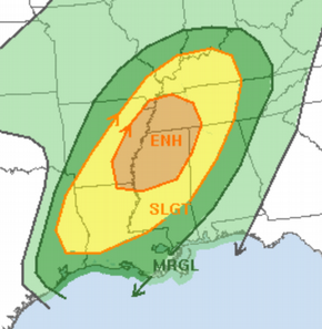
As the event approached, we started turning our attention to the “Convection-Allowing Models” (CAMs) such as the HRRR, the NAM-3km, and other similar models. We looked at the “UH tracks” (this stands for Updraft Helicity, a measure of the rotation of the updrafts in the model). We started seeing ominous signs of tornado threat with tracks across mainly Alabama, and a few into Georgia. By Saturday, it became clear that the threat that first caught our eye in the European forecast model was real, but that it was going to be shifted much closer to the Gulf Coast.

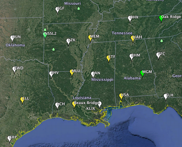
We began our special soundings from our university and NOAA-lab operated sites, and 13 NWS regular sounding sites, at midday Saturday. At that time, there was no CAPE or shear supportive of tornadoes to be found in the Southeast. The upper system was just moving into the Southwest US. By 6 AM Sunday morning, the potentially unstable air was just beginning to come onshore from the Gulf of Mexico, first showing up in our Breaux Bridge, Louisiana soundings (conducted by the University of Louisiana-Monroe), and the Slidell LA NWS sounding. An additional sounding in mid-morning from our team at Mobile, AL (University of South Alabama) showed the rich airmass onshore in Mobile at that time. And by mid-morning Sunday, the big acceleration in the low-level winds across MS and AL had begun, so it was just a matter of time before the tornado-supporting flow and the rich Gulf air near the ground started overlapping in southeast MS, southern LA, and southern GA.

This season has featured a very large temperature contrast between the continental U.S., where many of us have been shivering, and the warm air masses to the south (such as over the Gulf of Mexico). This temperature contrast drives the strong westerly winds aloft and their embedded waves, and so we have repeatedly had strong low pressure systems capable of bringing warm humid air onshore and strong low-level wind shear supportive of tornadoes. Yesterday’s system brought together the strong shear with a bit higher CAPE than we have seen with the other systems, and the result was devastating. Unfortunately, there is no real end in sight to this energetic pattern.

During yesterday’s event, VORTEX-SE special soundings were being used by forecasters at the Storm Prediction Center and at the NWS forecast offices to help anticipate the degree of tornado threat. I was very impressed with how well forecasters were able to fine-tune the short-term outlooks and provide quality warnings. The sad loss of life tells me that we have to continue to work on making sure everyone understands, and is able to respond to, the information coming out of the NWS and communicated so effectively by the media and others.

VORTEX-SE stands to learn a lot from these events. We will get a clearer picture of whether/not/how additional observations can improve the numerical forecast models. With time, it’s almost certain that the forecast models can show tornado threat and even estimate likely tornado intensity with lead times of hours. That is the goal, anyway. The VORTEX-SE work is important in advancing this capability. In parallel, VORTEX-SE is supporting a lot of research (some of it happening today in Alabama) into how people respond to tornado forecasts and what obstacles stand in the way of getting people into shelter locations that can withstand the expected tornado winds. As forecasts continue to improve, we ought to be able to help people make reasonable sheltering decisions even if their homes are too fragile to withstand typical tornado winds.

I think I speak for most of the VORTEX-SE researchers in saying that tragedies like yesterday’s Lee County tornadoes hit us pretty hard. There’s no relishing or enjoyment. But that said, these events are the reason most of us do what we do, and motivate us to keep moving forward in this research.

Tags: None

STATUS: 22 Feb 2019

Our fifth Intensive Observing Period of this cool season began at 6 AM this morning with special sounding launches from ten sites operated by universities and NOAA labs. The information from these soundings is going to be valuable as an intense low pressure system develops in the Plains later today. In collaboration with the NWS, VORTEX-SE will perform special soundings every six hours through 6 AM Sunday morning. By Sunday morning, the cold front with this particular weather system will have swept most of the way out of our observing domain. These are the sounding sites that are being used:

As this weather system sweeps across the Southeast, it looks like the storms will have the potential to produce tornadoes. Right now, the models show the greatest threat extending across northern LA and southeast AR, through the northern half of MS, and into western TN and northern AL. The severe weather should develop around midday Saturday, and move quickly northeast to AL and middle TN by late Saturday evening. There may be a few relatively isolated supercells ahead of the main band of activity, and then the main band of activity will probably be comprised of fairly tightly spaced supercells. At 11:30 AM CST the SPC issued this outlook:

Some of the uncertainties with this system include the expected tornado intensity, the northern and southern extents of the threat, and how late into the evening on Saturday (and how far north and east) the activity will persist. Often with these systems that appear to have a pretty high threat, there is some unexpected or poorly understood aspect that ends up limiting the threat. These limits to the threat are as important to understand as the factors that come together to produce the threat.
An additional complication with this system is the tremendous amount of rain and consequent flooding that has occurred, and will continue, across northern AL, TN, northern MS, and adjacent regions. These “multiple-hazard” events are not unusual in the Southeast, and complicate the work of all involved in the weather enterprise.

Tags: None

STATUS: 28 November 2018 IOP #2

With the news being about Midwest blizzards, Black Friday, and Cyber Monday, it doesn’t seem right that VORTEX-SE should be active. But we are.

Over the last couple of years, we have grown increasingly concerned about observing the “cool season” tornado events in the Southeast.

The peak occurrence of killer tornadoes in the Southeast spans a broad season from October through early May. Tornadoes this time of year are especially concerning because of the perception that tornadoes are a springtime phenomenon. People let their guard down during the fall and winter.

On Friday, an upper wave and jet stream will be plowing into the Southern Plains. As pressures fall, strong low-level flow will develop off of the Gulf of Mexico, transporting warm humid air inland. Combined with the upper level jet stream flow, profiles of temperature, humidity, and wind ought to become favorable for increased tornado potential, first in east TX, LA, and AR Friday evening, and spreading east into MS Friday night (30 Nov). The system will then chug east into AL/GA on Saturday. At some point, it will outrun the richer Gulf moisture and move into the cooler drier continental air left behind by the last system over the eastern US, and the tornado threat should diminish.

This cool season, VORTEX-SE will be doing an experiment aimed primarily at improving forecasts of tornadoes on time scales from a few hours to about 2 days. Starting at about the time the upper system enters the Plains, many Southeast NWS sites will be launching soundings every six hours, continuing for 48 hours. In addition, university and NOAA Lab partners will be launching soundings at the same times from College Station TX (Texas A&M), Fort Smith AR (NSSL), Monroe and Breaux Bridge LA (University of Louisiana at Monroe), Memphis TN and Starkville MS (Mississippi State), Mobile AL (University of South Alabama), Huntsville AL (University of Alabama-Huntsville), and Montgomery AL and Oak Ridge TN (NOAA Air Resources Lab, Atmospheric Turbulence and Diffusion Division).

In addition to this regional-scale observing campaign, we will be doing “nested” finer-scale observations in northern AL to get a look the details of the features we detect moving through the larger domain. This will include two “CLAMPS” profiling systems from NSSL and OU, as well as profiling, mobile radar, and mobile sounding systems from the University of Alabama-Huntsville. And the Texas Tech instrumented surface network (“Stesonet”) will be making observations across northern AL and southern TN, with instruments spaced roughly in every county.

All of this is part of the ongoing VORTEX-SE effort to improve the forecasting of, and human response to, tornadoes in the Southeast. These tornadoes are unlike their Plains counterparts in that they occur across a longer part of the year, are much more likely to occur at night, and occur in complex scenarios and from storm types that just have not been studied very well in the past.

Erik

Tags: None

STATUS UPDATE: 4:05 PM Tue 3 April

The NOAA P-3 is working a tornado-warned storm to the northwest of Batesville, and south of Melbourne, AR. Storms to the southwest of there continue to get more interesting as well, but are currently too difficult to operate on… the aircraft needs some space on the inflow side of a storm to gather research-worthy dual-Doppler data.

The storms are barreling east toward an evening encounter with our mobile radar network in NW AL.

Tags: None

STATUS UPDATE: 19 March 2018

STATUS: Down

The IOP is completed. Several tornadic supercells were observed, with a number of tornadoes occurring. The level of damage is not clear yet.

We succeeded in collecting many volumes of multiple-Doppler data involving ground-based and airborne radars.

Many soundings were obtained, at an hourly interval, to document the evolution of the environment.

The next potential for operations appears to be toward next weekend.

Tags: None

STATUS Update: 19 March 2018

STATUS: Operating.

One supercell with a low-level meso is moving through our multi-Doppler coverage northeast of Huntsville; the P-3 has been scanning this storm for most of its life. No tornadoes from this so far… lots of hail. This is the kind of data set we were seeking this year to test approaches to measuring 3D winds using multiple simultaneous Doppler radars.

Another supercell is forming south of Huntsville and moving toward Sand Mountain, also in good multi-Doppler coverage. This provides an alternative target for the P-3 aircraft if they have trouble scanning the northern storm.

New storms are forming in MS and will move into AL in a couple of hours. Low-level hodographs are starting to lengthen. A PDS tornado watch has been issued for all of our study area.

Tags: None

STATUS: 19 March 2018

We are operating. All five ground-based radars are scanning, and the P-3 aircraft is attempting to find a way to scan the storm in NW AL. This storm has a tornado warning, and we suspect it will stay connected to the surface warm front as it continues east toward the Huntsville area in about an hour. Thereafter, it will enter our Doppler radar domain.

We still anticipate another round late this afternoon/evening.

Tags: None

STATUS update: 18 March 2018

We have just finished our planning meeting. A number of sounding and profiling systems will be deployed across northern AL in the morning on Monday. We still expect a line of supercells to initiate around 2 PM in far eastern MS, and move east across northern AL at about 50 mph. The NOAA P-3 aircraft will take off from Huntsville at 2 PM. We expect the supercells to pass Huntsville around sunset, and then move on into Georgia. We will have five radars on the ground… ARMOR, two SMART-radars, MAX, and the Hytop WSR-88D, and these will be covering all of NE AL and far southern TN, generally east of I-65.

Tags: None

STATUS: 18 March 2018

STATUS:IOP

We have moved the U. Oklahoma SMART-Radars to the northern AL subdomain at Huntsville, and all the needed platforms should be available for a mission tomorrow (Mon 19th).

Despite small run-to-run fluctuations, the numerical guidance continues to show the potential for tornadic supercells in the domain tomorrow. Some significant tornadoes may occur. This overall theme has been present in the forecasts since Thursday morning, but that’s no guarantee that it will come about.

I sent a special heads-up email this morning to a group of more than 20 researchers in the social, behavioral, and engineering sciences because many of these folks are engaged in studying how the lead-up to tornado events influences reactions to an actual threat, and many of them need to do research immediately following tornadoes or tornado warnings. We all hope for no suffering, while still being ready to learn how to reduce or prevent the suffering caused by future events.

Right now, we are expecting convection to develop in eastern MS around 2 PM, and sweep east across AL and into GA by sunset. The P-3 aircraft is scheduled to take off at 2 PM on Monday.

I will try to post an update just prior to our observing mission… midday Monday.

Tags: None