Leader, engineer, and innovator in Doppler radar passes away

Richard “Dick” Doviak

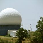
Richard “Dick” Doviak, a renowned radar engineer and professor, passed away recently.

Research conducted by Doviak and others at the NOAA National Severe Storms Laboratory helped convince the NOAA National Weather Service of Doppler radar’s crucial use as a forecasting tool. Their work led to the installation of a network of NEXRAD Doppler radars across the United States in the early 1990s and still in use today. This Doppler technology ultimately revolutionized forecasters’ abilities to understand and track severe weather, saving lives and property.

Doviak’s list of accomplishments is long. He managed several research projects, was a Fellow with both the Institute of Electrical and Electronics Engineers and the American Meteorological Society, and authored many articles published in more than 20 journals spanning interests in geosciences, engineering, physics, and meteorology. He also won a gold medal in the Oklahoma Senior Olympics for bicycling.

“Dick [Doviak] was always warm, generous, and friendly, the kind of person that we all enjoy having chance encounters with,” said Jack Kain, NOAA NSSL Director. “That part of his legacy will live on in all of us, and of course his contributions to science, engineering, and mentoring are legendary – at the lab, OU, and elsewhere. His work forms a large part of the foundation of NSSL, and indeed the national infrastructure, with the radar technology that he developed serving to protect lives and property across the nation every day. At NSSL we are all honored to have known Dick and worked with him.”

His career

Doviak received an invitation to join NOAA NSSL and lead the Doppler Radar Project in December 1971, almost 50 years ago.

“There were two priorities. One was using Doppler radar to study the dynamics of severe thunderstorms,” Doviak said during a “Radar Roundtable.” “The other priority was building a real-time display. I think NSSL had the very first real-time Doppler velocity display in 1972, as a matter of fact.”

Doviak led the radar project until 1987. NSSL spent nearly 30 years researching and developing Doppler radar technology.

However, Doviak considered polarimetric Doppler weather radar the most significant advancement in his field during his time at NOAA. Dual-polarization technology added to NEXRAD about 10 years ago provides National Weather Service forecasters a measure of the size and shape of precipitation and objects, like hail.

These early collaborations and discoveries impacted Doviak’s work and the advice he provided to students throughout his career.

A grayscale WSR-88 radar display from 1979. (NOAA)

His heart

Doviak transitioned as lead on the Doppler Radar Project and became a senior research scientist at NSSL, as well as an affiliate professor with the University of Oklahoma (OU) School of Meteorology and the College of Engineering. One of the main reasons he chose to work at OU was the opportunity to teach and mentor students. Once he arrived, he was instrumental in developing the OU meteorology course on Doppler Radar with fellow NSSL Senior Scientist Dusan Zrnic.

“One thing about Dick is that he was always available to help mentor students,” said Kurt Hondl, NSSL deputy director. “Back when I was a grad student, Dick was always willing to review and discuss my thesis, even though he wasn’t on my Master’s committee.”

Doviak and Zrnic co-authored the book, “Doppler Radar and Weather Observations,” based on their OU course. The book is considered a necessary meteorology text by many in the weather community.

“For a young grad student, it was such a seemingly unreal experience to be discussing my results with Dick and Dusan [Zrnic] who had literally written the book on Doppler Weather Radar Observations. Of all my textbooks over the years, it is the one that I have cracked open time and time again throughout my career,” Hondl said.

Doviak enjoyed sharing his passion for research with those around him. He wanted to see everyone succeed. Researcher Sebastian Torres recalls one of his first projects as a Cooperative Institute for Mesoscale Meteorological Studies (CIMMS) researcher. In the late 1990s, Torres was working with Doviak to measure radiation patterns of the local KOUN Weather Surveillance Radar antenna. This research would serve as a proof-of-concept for the eventual upgrade of the entire NEXRAD network in the early 2010s.

“As a very inexperienced researcher, Dick caringly held my hand through complex data analysis processes and, with his characteristic humbleness, mentored me on the production of figures for formal publications,” Torres said. “Throughout this process, Dick taught me a very valuable lesson that has served me well in my scientific career: pay attention to every detail and leave no stone unturned. You never know where the key that opens the next big discovery will be.”

Sebastian said he will always remember Doviak’s inspiring enthusiasm and contagious joy for inquiry and discovery.

Doviak practiced the art of being good at your work, enjoying life, and being kind to everyone. Mass of Christian Burial will be celebrated and live-streamed from St. Thomas More University Parish, Norman, Oklahoma, at 11:00 am CT on March 23, 2021. A celebration of life is planned once everything is safer. Donations are encouraged to the American Cancer Society.

Staff photo of NSSL employees in 2012
Dick Doviak, top left laying on the concrete barrier, at an NOAA NSSL staff photo in 2012. (Photo by James Murnan/NOAA)

Richard “Dick” Doviak’s Awards

  • 1980 NOAA Outstanding Scientific Paper
  • 1981 NASA Group Achievement Award for distinguished scientific contributions to the definition, planning, and execution of the Doppler Lidar 1981 Flight Experiment.
  • 1982 NOAA Outstanding Scientific Paper
  • 1988 IEEE Fellow
  • 1988 IEEE Harry Diamon Memorial Award for outstanding technical contributions in the field of government services in any country.
  • 1993 IEEE Geoscience and Remote Sensing Society Outstanding Service Award
  • 1999 AMS Fellow
  • 2014 NOAA Distinguished Career Award “for development of breakthrough radar methods that have greatly enhanced operational severe weather detection and advanced meteorological research.”
  • 2016 Remote Sensing Prize for “fundamental contributions to weather radar science and technology, with applications to observations of severe storms and tropospheric winds.”
Dick Doviak receiving an award from former NSSL Director Steve Koch. (Photo by James Murnan/NSSL)

VIDEO

Share this:

Researchers developing experimental winter forecasting tools

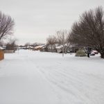
Last month, millions of people across the United States were impacted by several inches to feet of snow and the coldest temperatures in decades. Thousands lost power and water, and travel was treacherous as multi-vehicle pile-ups forced interstate shutdowns.

To help lessen these impacts, researchers at the Cooperative Institute for Mesoscale Meteorological Studies at the University of Oklahoma and the NOAA National Severe Storms Laboratory in Norman, Oklahoma, are working to improve current winter road tools. They are focused on predicting and monitoring a variety of winter hazards and the potential impacts of such weather.

“Hazards may include accumulating snow or ice on roadways, slushy roadways, and others,” said Shawn Handler, a researcher at OU CIMMS. His work supports NOAA NSSL. “It’s possible a winter storm may pose a greater threat to one infrastructure more than others, like maybe travel or power outages.”

A mailbox topped with snow.
A snow-covered home and mailbox in Oklahoma. Winter weather ravaged parts of the United States in February, leaving many without power and water. (Photo by James Murnan/ NOAA)

Handler, with a team of other researchers, are developing two experimental products: the Experimental Road Hazards Product and Probability of Subfreezing Road Temperatures (ProbSR) product. These are expected to be integrated into the National Weather Services’ Winter Storm Severity Index (WSSI).

The Experimental Road Hazards Product will provide information on specific hazardous road threats, like ice.
The experimental Probability of Subfreezing Road Temperatures (ProbSR) product uses current and immediately available information to predict if road temperatures are subfreezing.
The Winter Storm Severity Index (WSSI) is an operational product designed to provide impacts-based decision support to NWS forecasters in order to allow them to provide more target messaging to the general public and other government stakeholders. This product is developed and supported by NCEP/Weather Prediction Center.

These tools can be used together to increase the amount of winter-storm information available to National Weather Service forecasters and emergency officials.

Integrating the tools

Aimed to improve winter-weather advisories, the WSSI ingests several different sources of information but none of those sources provide information on the roads. Researchers want to pair WSSI with the ProbSR product, allowing forecasters to have greater confidence about the potential for winter-weather to result in treacherous driving conditions.

“It’s possible a winter storm may pose a greater threat to a certain infrastructure compared to others,” Handler said. “For example, Oklahoma City experienced an ice storm in October and impacts to the power grid outweighed the impacts to road travel, as hundreds of thousands of people lost power for an extended period of time.”

Integrating ProbSR and the road-hazard tool into the WSSI will allow ProbSR to be tested and evaluated as a forecasting tool next winter in a testbed environment.

Hazardous road threats are determined by pairing the road temperature tools of ProbSR with another model providing precipitation classification at the surface, like snow and rain, to create the Experimental Road Hazards Product.

“We are focused on what hazards or threats may be present,” said Handler. “For example, it could be snowing, but if ProbSR has low probabilities, the expected threats to travel may not be as high – such as a wet roadway as the snow is not expected to accumulate. Whereas, if it has been cold enough for a longer stretch of time – a higher ProbSR – and snowing, then accumulating snow would be the resulting hazard.”

Icicles hanging from the edge of a home roof.
Many states experienced the coldest weather in decades. Cold temperatures were accompanied by ice, snow and other winter precipitation. (Photo by James Murnan/NOAA)

Continuing research

Handler said tests with the products are successful, but the team is retraining ProbSR with more recent data from the High-Resolution Rapid Refresh model (HRRR), a high-resolution weather forecasting model used by the NWS. The HRRR updates forecasts hourly over the entire lower 48 United States at a resolution of less than two miles.

The Experimental Road Hazards Product is in the early stages of development. The team continues to investigate ways to improve it, including gathering more inputs, such as precipitation rate and wind speed.

“Precipitation rate will provide information on how fast precip – like snow, rain, ice – is falling, whereas wind speed could be included as a way to assess visibility threats,” he said. “We also want to include more threats utilizing these new inputs, such as reduced visibility from blowing snow.”

The researchers’ next steps regarding the Road Hazards product are to add some of the features described above, and to properly verify the classifications made from the algorithm using traffic camera observations.

Products will be tested by researchers and forecasters in the winter of 2022 in a joint testbed with the NOAA Weather Prediction Center.

Share this:

New rating system charts a path to improved tornado forecasts

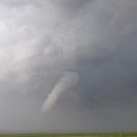
All tornadoes — whether small or large — originate from thunderstorms, but not all thunderstorms are the same. Different environments and situations create forecasting challenges. For instance, nighttime twisters, summer tornadoes and smaller events can be tougher to forecast.

Researchers wanted to quantify how much tougher, and have published a new method of classifying tornado environments according to their forecast difficulty.

In a new paper published online in the Bulletin of the American Meteorological Society, University of Washington scientist Alexandria Anderson-Frey, and Harold Brooks from the NOAA National Severe Storms Laboratory describe a new way to rate and possibly improve tornado warnings.

“With this research, we’re trying to find ways to truly level the field related to the difficulty of the forecast situation,” said Brooks. “This will help us identify areas for research, as well as better understand the long-term historical statistics.”

 The paper presents a new method to rate the skill of a tornado warning based on the difficulty of the environment. It then evaluates thousands of tornadoes and associated warnings over the continental United States between 2003 and 2017.

The NOAA-funded study finds that nighttime tornadoes have a lower probability of detection and a higher false-alarm rate than the environmental conditions would suggest. Summertime tornadoes, occurring in June, July or August, also are more likely to evade warning.

“The forecasting community is not just looking at the big, photogenic situations that will crop up in the Great Plains,” said Anderson-Frey, the lead author. “We’re looking at tornadoes in regions where vulnerability is high, including in regions that don’t normally get tornadoes, where by definition the vulnerability is high.”

The technique could be applied to forecasts of other types of weather as well.

This research began while Anderson-Frey was a postdoctoral researcher at the Cooperative Institute for Mesoscale Meteorological Studies, a partnership between the University of Oklahoma and NOAA.

This story was adapted from a  University of Washington news release.

Share this: