25 March update

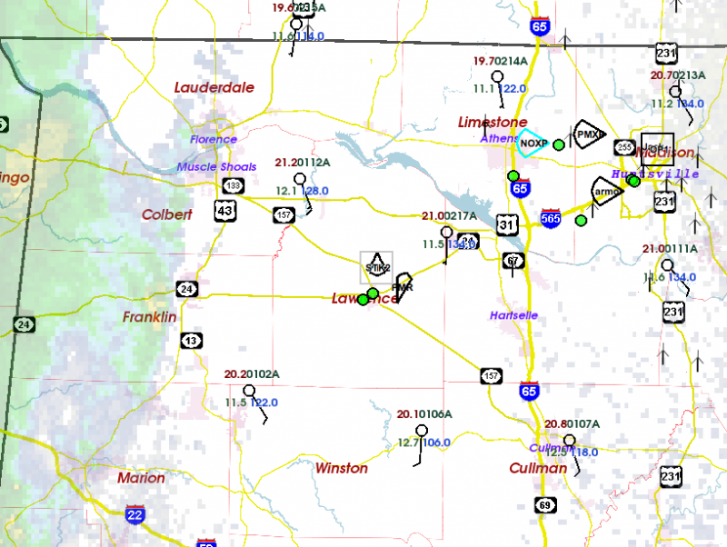
We just collected data on a nice little wave in a line of weak storms. It persisted all the way across our domain, over a period of a couple of hours.  As it neared the north side of the domain, the associated rotation developed decent shear (change in Doppler velocity across the circulation).

As far as I can tell, we had an excellent deployment of sticknets (surface weather instruments) and disdrometers (to measure raindrop size).  These two measurements are related in purpose… the raindrop size and count is related to the coolness of the storm outflow, which seems to be related to tornado potential.

The storm also moved through our radar array, and it seems that the data collection was good.

This case may be interesting because  it seemed to be on the borderline between non-tornadic and weakly tornadic.  Sometimes borderline cases are the most useful because they add information about the thresholds of things like CAPE and shear that can be used to predict tornadic versus non-tornadic.

Tags: None

STATUS: 25 Mar 17

STATUS: IOP

We are in the field for the first IOP.  Right now, the tornado potential is much lower than what the numerical forecasts suggested the last few days.  CAPE is near zero, and we’re not sure how much it will grow over the next few hours.  Shear is also less than expected.

But we have a nearly full suite of instruments in the field beginning observations.  A very weak line of convection is edging into AL from MS.  Some guidance still suggests this will intensify early this afternoon with a lower-end risk of rotating updrafts.

Erik

Tags: None

STATUS: 24 Mar 2017

STATUS: IOP

The researchers have arrived in Huntsville for the upcoming observing work.

This morning, all of the high-resolution forecast models are showing a band of storms moving into AL tomorrow.  The forecasts vary from a midday passage near Huntsville to an after-dark passage. The uncertainty is huge.  Uncertainty here in AL is normally larger than anything I have experienced in the Plains, but this case is one of the most uncertain I remember.

One thing that looks more certain is storm rotation.  CAPE and the wind profiles look supportive of rotating storms, with the wind shear in the lower atmosphere possibly supportive of a tornado threat.

So… the researchers will meet at 8PM tonight to see if we have a better picture of what will happen tomorrow.  And likely we will meet one more time at 8 AM tomorrow to finalize our “plan-of-the-day”.

Because of the uncertainty, the nighttime mission of the NOAA P-3 “hurricane hunter” aircraft has been cancelled.  There was no way to fly tonight, rest the crew, and take off again at a reasonable time tomorrow.  Instead, the flight is now scheduled to begin at 11 AM tomorrow, and finish by 11 PM.

Because this is our first mission this year, and the weather looks particularly busy, I doubt I will be able to blog tomorrow.  Maybe when the mission wraps up…

Here’s a cool set of pictures from our recent media day.

VORTEX Southeast 2017 media day

Tags: None

STATUS: 23 Mar 2017

STATUS: IOP

Researchers are on their way to Huntsville AL for the first IOP.

Forecast models are still portraying the overall scenario of the last few days.  A significant wave will pass through AL Saturday and Saturday night.  It looks like there will probably be a QLCS on Saturday night, and shear and CAPE look sufficient for there to be tornado potential.  Around here, CAPE > 0 is of concern; this system looks like it will have CAPE around 500 J/kg, possibly approach 1000 J/kg during the afternoon.

We are also watching for the risk of a few storms, perhaps with tornado potential, ahead of the QLCS.  With the typical very weak cap in the low-levels, any lifting could get things going, and this is usually not forecast well by any of the current models.

This forecast process has been fairly consistent with what we experienced last year.  The large waves that set up the conditions for tornadoes in the Southeast are reasonably well forecast in the global models.  The forecasted position, timing, and intensity fluctuates from day-to-day, but we’ve had pretty good luck deciding when to convene an IOP.  The details of when and where convection will form are very hard to pin down, and forecasting the likelihood of a tornado in time to let teams put instruments ahead of the storm is harder still.

It now looks like another wave will affect the region late Monday, with a return of conditions possibly supportive of tornadic storms.  Thereafter, it seems that the parade of waves might continue a bit longer.

Tomorrow the NOAA P-3 aircraft will conduct a solo mission to try to obtain Doppler radar data on the storms that occur in AR and LA.  On Saturday, they will fly again looking at the storms over our northern AL domain.

I will be busy with planning and operations tomorrow, and especially Saturday, so I may not be able to squeeze in blogging.

Erik

Tags: None

STATUS: 22 Mar 2017

STATUS: IOP

VORTEX-SE will be conducting its first IOP beginning Saturday, 25 March.  Researchers will be traveling to Huntsville AL and meeting on Friday evening to plan the Saturday activities based on the latest forecast guidance.

We expect a wave to cross the region, increasing the shear substantially on Saturday.  A band of convection is expected to move eastward into the domain out of Mississippi toward evening, but as we found last year, these details are hard to know more than 3-12 hours in advance.  Right now, it appears CAPE will be sufficient for storms, and down in the range we often call “Low CAPE” (around 500 J/kg).  Wind at about 1 km height is expected to be 40-50 kt, which is sufficient for low-level storm rotation.

The NOAA P-3 aircraft will do a mission into LA/AR on Friday, and then will join the surface team observations on Saturday.

I may be too busy to do the blog postings tomorrow and Friday, but will try to blog a time or two on Saturday.

Erik


Tags: None

STATUS: 20 Mar 2017

STATUS: IOP Watch

Some of the researchers are gathering in Huntsville AL to participate in a Media Day tomorrow.  It will be fun to share some of the complexities, goals, and challenges of VORTEX-SE.

The Huntsville area is in SPC’s Slight Risk outlook tomorrow.  This situation still looks marginal for any tornado activity, but hail and damaging wind looks more likely.  Some of the researchers are going to check out their equipment, logistics, communications, etc. if storms move into the area tomorrow.

We are still watching the weekend.  Not much has changed in the forecast… it appears a strong upper wave and attendant cold front will move through the VORTEX-SE observing domain.  The resultant weather depends, as always, on a lot of details that won’t become apparent until late in the week, and maybe not even until we do the analyses of our data with 20/20 hindsight.  But as things stand now, an IOP is looking more likely every day.

And by late in the week, we will possibly be dealing with the idea that this first IOP could possibly involve two or more episodes of potentially tornadic weather.

Tags: None

STATUS: 19 Mar 2017

STATUS: IOP WATCH

We continue to watch the event taking shape for the time period of 24-26 Mar.

This wave is just a minor feature about 1000 mi west of the California coast this morning.  And so how it takes shape depends a lot on the details of the flow in the jet that is beginning to interact with this wave.  It will be a day or two until the system advances into the denser observing network on the North American continent.

The models generally agree that a significant wave will pass through northern AL between Friday evening and Saturday night.  The devil is in the details.  The timing of the passage will make a big difference on how much CAPE builds up with daytime heating.  The intensity in the southern portion of the wave, in the lower Mississippi Valley, will make a big difference on the low-level flow, which impacts the rate at which moisture returns in low levels and CAPE develops, as well as the intensity and direction of the shear in the lowest 3000 ft or so.  That in turn affects tornado potential.  And all of these details factor into the mode of the storms… supercells, Quasi-Linear Convective Systems (“QLCS”… or squall lines), or something different.

For the NOAA P-3 aircraft, the questions are even bigger.  Because the aircraft can roam all across the Southeast, it can potentially observe an event too far west for the ground-based researchers, land and rest the crew, and then observe an event over Alabama.  And if the system is slow enough, potentially another round of observations further east the next day.

So the researchers continue to watch the forecast evolve, and think about how soon they need to be in Alabama, what kind of deployment strategies might work best, etc.  And with this system there is an additional logistical issue to think about: another wave is following right behind the first one, and may give us a second observing opportunity about 3 days later.  So we will have to pay attention to this second system and decide whether to end the IOP (if there is one) around Saturday night/Sunday, or stay in Alabama for another observing chance toward Tuesday or Wednesday.

Never simple.  Never clear.

Tags: None

STATUS: 18 Mar 2017

STATUS: IOP WATCH (new)

In the midday conference call today, the VORTEX-SE researchers decided to not conduct observations on Tue 21 Mar, but are now watching a likely IOP opportunity toward next weekend.  (If you haven’t been following these messages, “IOP” stands for “Intensive Observing Period”… that’s when the researchers hit the field with all their observing equipment.)

The Tuesday forecast illustrates one of the many challenges the researchers face.  Most of the VORTEX-SE researchers travel to Alabama to conduct observations because staying there for two months or more would consume resources better spent on the science.  The funds support about four IOPs.  And so they have to weigh the likelihood that an event will provide enough data to generate some new knowledge, and whether there will be better opportunities as March and April go on.

So on Tuesday, there will be enough CAPE around to support thunderstorms, if they were initiated.  (CAPE is “Convective Available Potential Energy” which measures how much updraft air will be accelerated because of the difference between the updraft temperature and the temperature outside the updraft.)  But, because of an upper ridge, the winds will be fairly weak through the whole depth of the atmosphere.  One can never rule out tornadoes completely, but given our current understanding of tornadic storms and the environmental conditions that support them, this looks like an extremely-low probability day.  If we had unlimited resources and could observe 24/7 for a number of months, we could probably catch one or two surprising events… and there’s probably a lot to be learned from them when they happen.  But we have to spend the research funds in a way that can give us the most new knowledge for the buck.

Looking ahead, we see another challenge.  The forecast models are pretty adamant that a strong wave and associated cold front will move through the Southeast toward this weekend.  Right now, the major models are in very poor agreement about the timing of this, and individual models are in poor agreement with themselves from one model run to the next.  It looks like an IOP is quite likely for this system, and it will be up to the researchers and their forecast team at the University of Alabama-Huntsville and NWS-Huntsville to try to get a good enough picture of the timing so that the researchers can assemble in Huntsville and plan the details of their deployment.  Stay tuned…

Tags: None

STATUS: 17 Mar 2017

STATUS: IOP WATCH

The outlook for the activity around the 21st of March continues to be unfavorable, and at this time, it appears an IOP is extremely unlikely.  While it appears that low-level heat and humidity will be sufficient for some thunderstorms, the winds aloft will have weakened so much that there should be very little tornado potential.  Around midday tomorrow, the researchers are likely to officially, finally, “pull the plug” on this IOP.

However, we expect that by tomorrow, details will start to come into a bit more focus regarding the large pattern change that is expected to occur over the US next week.  This pattern change is fairly likely to bring opportunities for IOPs to the Southeast US over the next couple of weeks.  The first period we are watching closely will be around Friday or Saturday (24-25 Mar).  There are a lot of things that could “go wrong” from the perspective of the VORTEX-SE researchers, so it’s way too early to declare an IOP.  But, we will begin watching this possibility tomorrow, and so we will probably again be in an “IOP Watch” for that later period.  Compare this forecast to the one posted up-thread:

Notice how this forecast for the mid-troposphere for late next week has flipped from an eastern trough-western ridge pattern, to the opposite.  This allows stronger southwest flow aloft to develop, and below that should be some fairly strong southerly flow bringing humidity off of the Gulf of Mexico.  As this first trough advances toward Alabama, one would expect a fairly strong surface system to eventually pass through the state.

Some of us will be traveling to Alabama next week to get together with the media at the HSV airport on Tuesday and try to convey all the unique, difficult, and exciting challenges this program faces.  So these blog postings may be hit-and-miss for the next few days.

Tags: None

STATUS: 16 Mar 2017

STATUS: IOP Watch

The VORTEX-SE researchers are watching the pattern change that has been forecast by the ensembles of global models for the past week or so.  This will be a change from the deep trough in the NE US (and the associated wintery weather there) and strong ridge in the western US.  The new pattern is likely to be one of a trough in the west, with waves moving through the flow and possibly affecting the VORTEX-SE domain.  There should be a big uptick in the strength of the upper flow as well, so supercells will become a greater concern as time goes on.

The first opportunity for observations may be on Tue 21 Mar.  This is another very difficult forecast problem, because the teams would like to make a decision on this event tomorrow (Fri 17 Mar).  If they could make that decision, they could take care of travel arrangements during the afternoon, and get to Alabama on Sunday or Monday.  If the decision isn’t clear until Saturday, then travel arrangements become much more difficult.  Right now, it looks like there may be CAPE (buoyant thermal energy to drive the updrafts) but it’s very unlikely that the atmospheric flow structure would support supercells.  So now we have to ask ourselves whether we think the flow, and the vertical shear of that flow, will be strong enough near the ground to support tornadoes from non-supercell storms.

So far in VORTEX-SE, we rarely have had an obvious “go” decision.  This is partly because during the 2016 campaign, and so far in 2017, there haven’t been any of the strong systems that are normally associated with tornadic weather.  It’s also because of the uncertainty that is always present 3-5 days before an event.

Tue 21 Mar is “Media Day” in Huntsville, when the media will have a chance to look at a lot of our instruments and interview us about the science issues surrounding the tornado problems of the Southeast US.

Tags: None