
A severe weather system rolled through central Oklahoma on April 19, 2023, producing supercell thunderstorms that yielded at least 18 tornadoes. These storms caused up to 200 injuries state-wide and one strong tornado killed one person near the town of Cole, Okla.,
With the most intense of those storms coming within mere miles of the NOAA National Severe Storms Laboratory (NSSL) in Norman, Okla., many of the lab’s teams jumped into action. From observations, to modeling to post-storm damage assessment, NSSL researchers gathered comprehensive data and put their cutting edge research to the test on storms in their own backyard.
NSSL researchers tested a dual-polarization, experimental phased array radar (PAR), several projects that fall under the FACETs (Forecasting A Continuum of Environmental Threats) framework as well as uncrewed aerial surveying. If transitioned to NOAA National Weather Service operations in the future, these technologies and approaches could produce better information for the public by empowering forecasters with better tools to issue more accurate and timely severe weather forecasts and warnings, even on the most challenging storms.
Below we will take a look at some of the programs in action on the evening of April 19 and their impact on the missions of NOAA and NSSL.
When severe weather rolled through central Oklahoma on April 19, 2023, including tornadic storms just miles from lab headquarters, researchers from the NOAA National Severe Storms Laboratory jumped into action, applying their cutting-edge scientific research to studying these destructive storms.

WARN-ON-FORECAST SYSTEM (WoFS)
The Warn-on-Forecast System (WoFS) is a NOAA research project that aims to increase lead time for tornado, severe thunderstorm, and flash flood warnings.
The Warn-on-Forecast project proposes one promising way to increase warning lead time—to harness high-resolution numerical weather prediction models and high performance computing, and to embrace the use of probabilistic information. WoFS is designed to make probabilistic predictions of individual thunderstorms out to six hours in advance, and update those forecasts every half hour using the latest radar and satellite data as a guide.
DATA COLLECTED
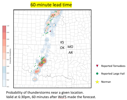
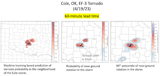
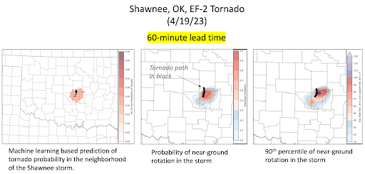
During the April 19 storms, the Warn-on-Forecast System accurately predicted the paths, intensity, and timing of several supercell storms. A new capability in WoFS is increased accuracy once a storm has appeared on radar and satellite data. At 5 p.m. that evening, WoFS latched onto the brand new developing storms and indicated a high probability of impacts in the Norman area over the next several hours.
After drawing a forecaster’s attention to the right area, WoFS provides several measures of the likelihood of specific hazard types and their potential strength. Making its adjustments every half hour, WoFS predicted two of the highest-impact tornadoes, at Cole and Shawnee, Oklahoma, with 60 to 90 minutes of lead time. The average tornado warning lead time in the United States is less than 15 minutes.
WHY WoFS?
Meteorologists and their tools are good at identifying which days will see severe weather in different regions, but warnings, which serve as an immediate call to action for specific storms affecting specific locations, are usually issued within minutes of local impacts. Warnings have traditionally been based on detection or indicators of severe hazards using National Weather Service Doppler radars, and trends in yearly-averaged tornado warning lead time reveal this “warn-on-detection” approach has reached a plateau. WoFS offers a way to provide more notice, and more time to take action.
THE IMPACT
As one of NOAA’s strategic goals, increasing lead time for severe weather warnings is intended to reduce loss of life, injury, and damage to the economy.
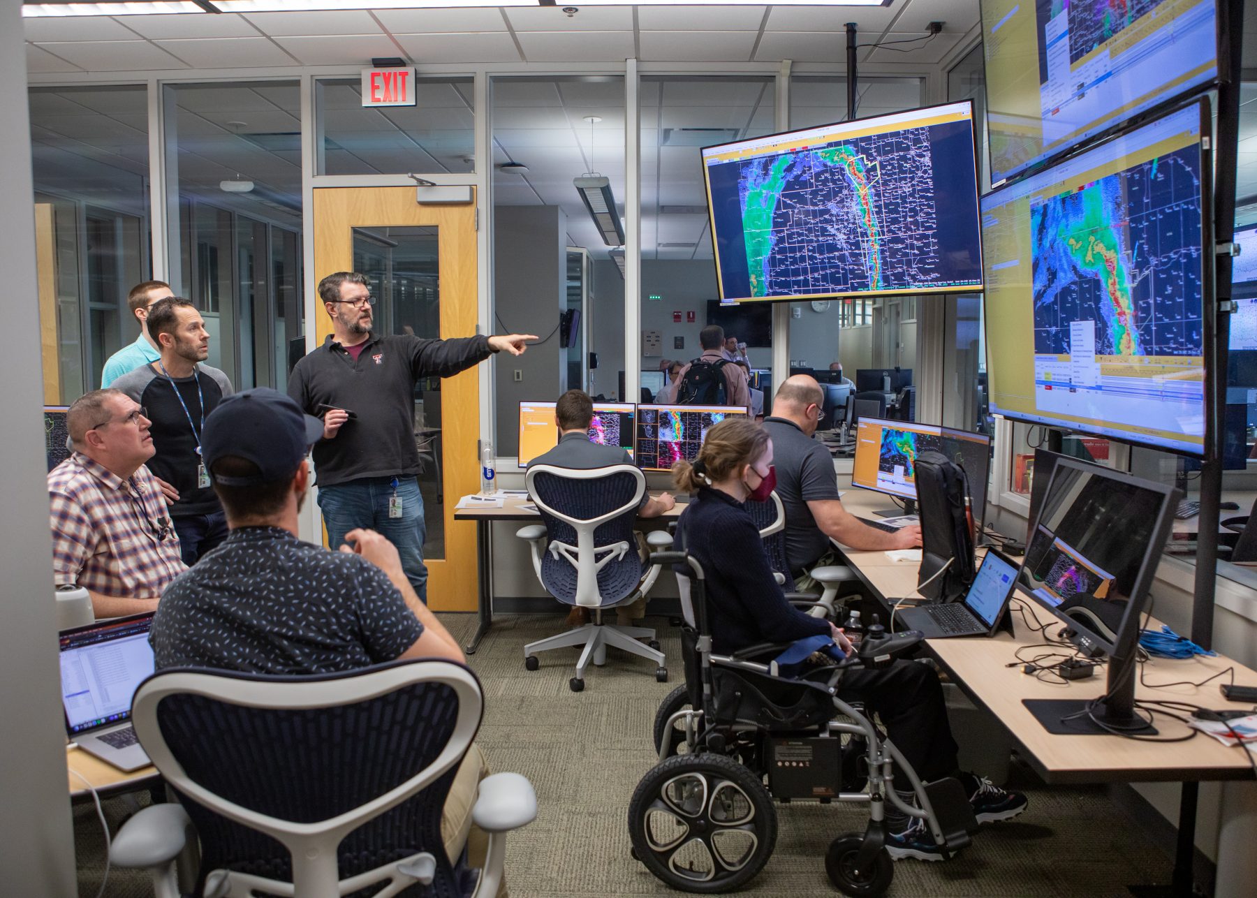
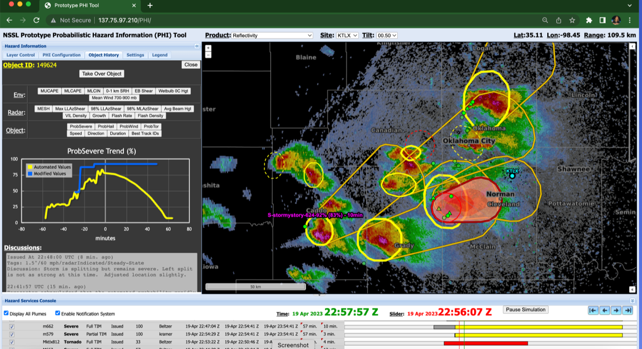
The NOAA Hazardous Weather Testbed (HWT) in Norman, Okla., develops, tests and evaluates emerging severe weather forecast and warning technologies for the entire United States. On April 19, 2023 NSSL researchers at the HWT tested a new way of issuing tornado warnings that move with a storm or tornadic circulation.
NOAA HAZARDOUS WEATHER TESTBED (HWT)
NOAA’s Hazardous Weather Testbed (HWT) develops, tests and evaluates emerging severe weather forecast and warning technologies for the entire United States. The HWT is a joint facility managed by NSSL, the NOAA Storm Prediction Center (SPC), and the NOAA National Weather Service Norman Weather Forecast Office located at the National Weather Center in Norman, Okla.
DATA COLLECTED
During the April 19 event, forecasters tested the creation of storm-based probabilities and Threats-in-Motion warnings that move with each individual storm and/or tornadic circulation. Storm-based probabilities are created using a blend of machine learning and forecaster analysis of the storms and environment.
Warnings that move with the storm could allow the forecasters to update warnings more quickly and could provide more equitable lead time to people downstream of the hazard.
WHY HWT?
The HWT provides a conceptual framework and a physical space to foster collaboration between research and operations to test and evaluate emerging technologies and science for NWS operations. This space is a springboard for the technologies of tomorrow.
THE IMPACT
Part of NOAA’s mission is to understand and predict changes in climate, weather, ocean and coasts and to share that knowledge and information with the public. NWS strategic goals aim to reduce the loss of life, injury, and damage to the U.S. economy. The NOAA HWT supports both by increasing the development, application, and transition of advanced science and technology to operations and services, and looking for ways to increase the lead-time and accuracy for weather and water warnings and forecasts.
PHASED ARRAY RADAR (PAR)
WHAT IS PHASED ARRAY RADAR?
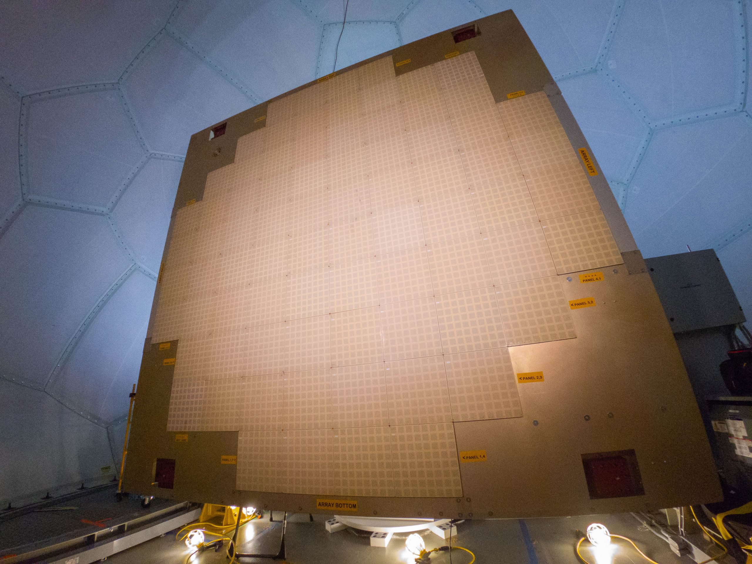
Current weather radars mechanically rotate and tilt the radar dish to sample different parts of the atmosphere. A phased array radar (PAR) has a unique flat panel antenna made up of a grid of thousands of fixed antenna elements, and each can transmit and receive a signal. As a result, the radar beam can be steered electronically, giving users the ability to control how, when and where the radar scans.
DATA COLLECTED
NSSL is currently developing the next generation of weather radar; phased array radar.
The Advanced Technology Demonstrator, or ATD, houses a large dual polarized phased array radar that NSSL is currently using to further develop and refine the technology. NSSL has been working diligently to advance this radar technology from a conceptual idea to a proven and potentially operationally capable product. On April 19, the ATD was operational and scanned tornadic storms as they passed through Central Oklahoma.
WHY PHASED ARRAY?
PAR scans the environment very rapidly, revealing critical weather thumbprints that point to the potential of severe weather. The ATD phased array radar scans every minute which will allow warning decision makers to detect severe weather faster and make warnings more accurate and timely. Forecasters will also be able to watch changes in the storm to know when it is strengthening or weakening.
THE IMPACT
PAR can assist forecasters in making more accurate and timely severe weather warnings, ultimately with the goal to reduce loss of life and injury.
UNCREWED AERIAL SYSTEMS (UAS)
WHAT IS UAS?
NSSL scientists use uncrewed aircraft systems (UAS) in post-storm damage assessments to better document high-wind damage and understand how tornadoes produce damage. UAS platforms are used to survey high-wind damage, collecting centimeter grid resolution imagery (videos) and producing georeferenced maps.
DATA COLLECTED
After the April 19 event, NSSL researchers used UAS fixed-wing and multirotor copter devices as well as satellites to obtain high-resolution imagery of tornado damage impacts. Multirotor copters were used to collect high-resolution videos of tornado damage of the Cole and Etowah, Okla., tornado tracks. The fixed wing was used to collect visible and multispectral imagery of tornado damage in Cole, Okla.. High-resolution multispectral satellite imagery was also obtained for the Cole, Etowah and Shawnee, Okla tornado track.

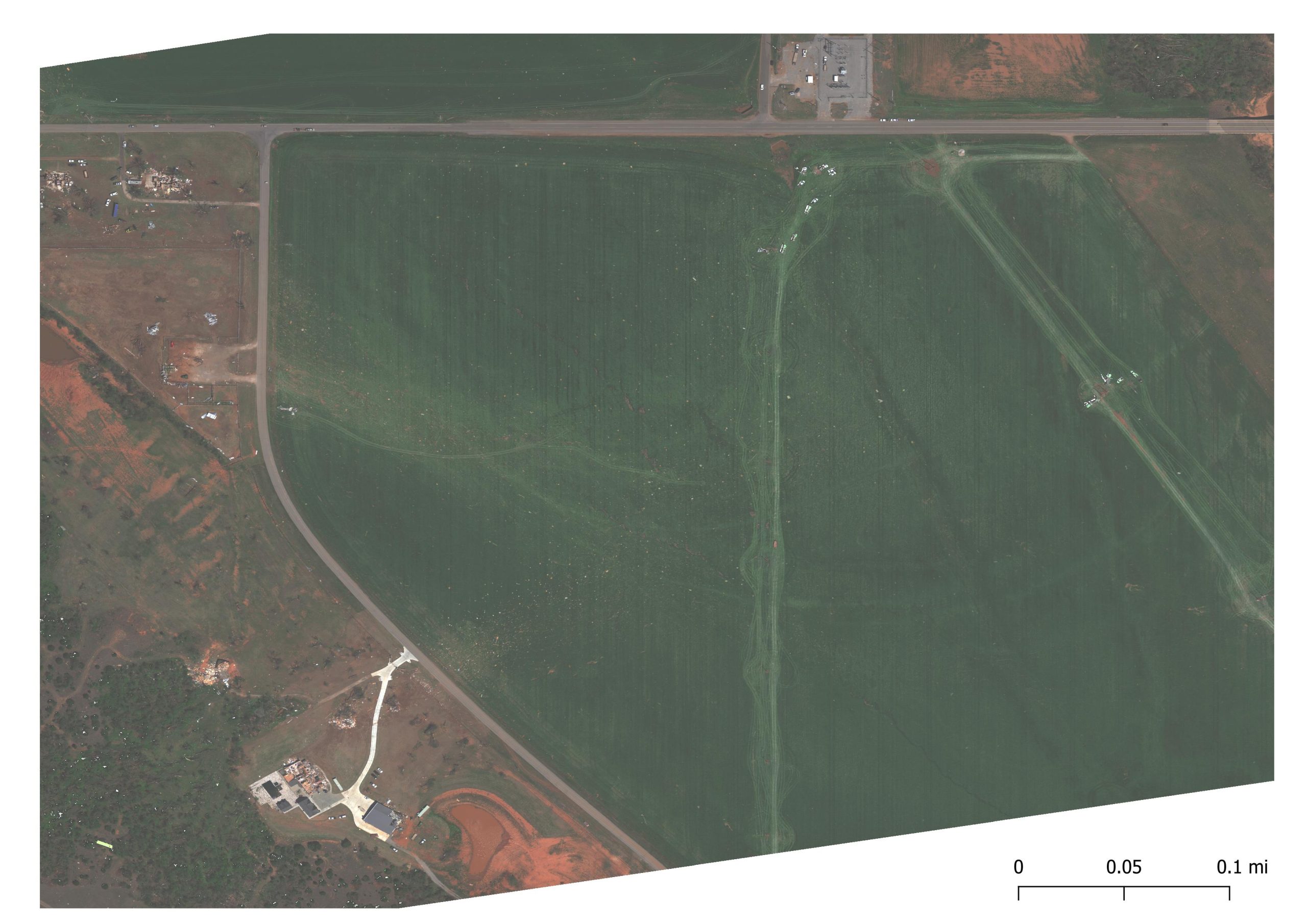
UAS mapping imagery of tornado damage in a wheat field from the April 19, 2023 EF 3 Cole, Okla., tornado. The exceptionally hi-resolution imagery was captured with a fixed wing aircraft and allows for detailed analysis of damage to vegetation. True color composite shown left. Swipe to see how multispectral imagery (right) can better detect damage to vegetation.
WHY UAS
UAS platforms can be deployed almost immediately after a high-wind event, capture damage information in remote or inaccessible areas, and better document damage to vegetation and in rural areas. High-resolution multispectral imagery can better detect damage to vegetation not visible to the human eye and used to develop additional damage indicators for vegetation that are more reflective of tornadic intensity. This information is used to better characterize high-wind damage to vegetation and in rural areas, which is frequently underestimated due to the inability to detect vegetation stress, limited vegetation damage indicators, and low population density.
UAS high-resolution damage information is also used to better correlate storm signatures observed in radar as well as understand the role of land cover and topography in tornado intensity and evolution.
THE IMPACT
High resolution imagery allows us to better document and understand tornado impacts by linking damage information with other observed datasets. The aim is to better rate tornadic intensity in rural areas, which are often underrated due to limited damage indicators, and better understand the role of land cover and topography in tornadic intensity and evolution. Improving our understanding on how tornadoes produce damage can help decision-makers and engineers better understand our vulnerabilities to high-winds and lead to more resilient strategies and designs.
This work has the potential to improve severe weather forecasts and warnings through better documentation of severe weather events and better assignment of damage ratings. This detailed UAS information will likely improve the accuracy of the severe storm report database and tornado climatology. Additionally, more accurate damage information will also improve disaster loss estimates for FEMA, insurance agencies, and the affected public. 


