

Status: DOWN
This is the first official day of the VORTEX-SE 2017 Field Campaign.
The weather pattern is not supportive of tornadic storms in the near future, so our status is DOWN.
We had been watching the forecasts for a system that is expected to pass northern AL on Saturday (11th), but as time has passed, it has become apparent that this system will just lead to a cool, rainy day, with almost no potential for storms that meet our research needs. One of our forecast models even shows the possibility of snow in Tennessee, perhaps reaching into the far northern fringes of Alabama.
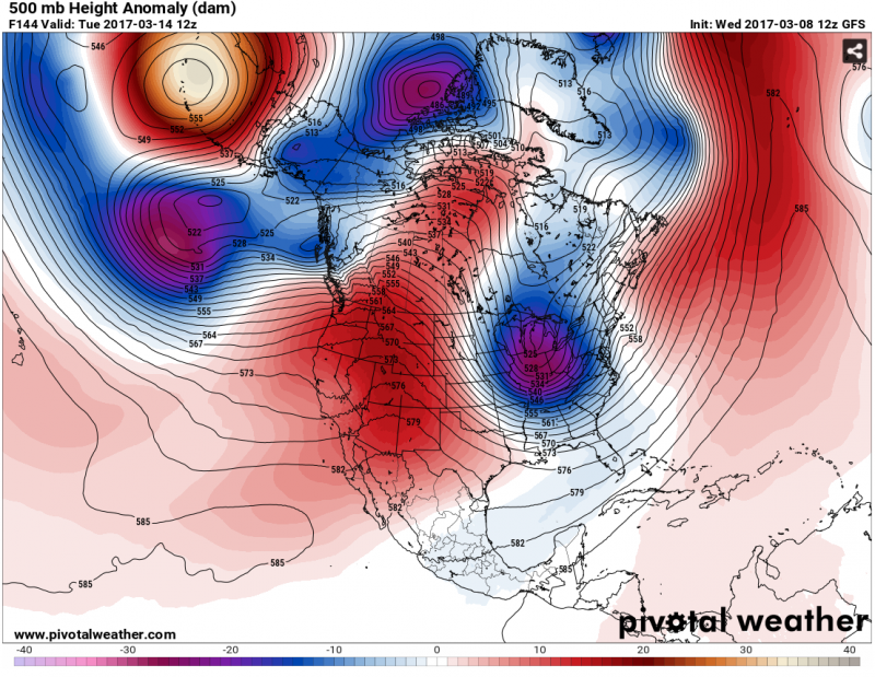
After that, the overall trend is for fairly frequent passages of fronts leading to cool, dry weather. This image shows the difference-from-normal of the conditions in the middle of the atmosphere (500 mb), forecast for five days from now. It shows that it is more “troffy” in the northeast and eastern Canada, and more “ridgy” in the Great Basin, than normal. Between these two areas, the jet stream air moves from northwest to southeast, driving the cool, dry air masses from the northern Plains and Canada toward the southeast US. These two features are pretty persistent over the next week or so in the GFS forecast model.
There are hints in our best forecast tools that the pattern may become more active again in a week or ten days. But even our best forecast tools have very little skill that far in the future. So, stay tuned.
So now the forecast team will start looking further down the road. When it looks like there may be targetable weather within seven days, we will switch the experiment status to “IOP WATCH”. In VORTEX-SE, that simply means that the teams of scientists are collaborating on the forecast, and thinking about travel arrangements, logistics, and instrument status. When our confidence becomes even higher that there will be weather suitable for our studies, we will switch to a status of “IOP”. This means that teams from Texas Tech, Colorado State, Purdue, the University of Oklahoma, NSSL, the University of Massachusetts, and the NOAA Air Resources Lab in Tennessee will travel as quickly as possible to Northern Alabama to commence observations. Because of all of the travel, and the limited research budgets, this decision is close to irrevocable.
It seems that this winter has featured higher humidities in the low levels of the atmosphere over the Gulf of Mexico than commonly observed. I don’t have any analyses or numbers to back that up… just a subjective sense. High dewpoints are a key ingredient in tornado potential. So if this trend persists into the spring, we might expect a more active tornado season than typical. Of course, high dewpoints, leading to greater updraft energy, are just one ingredient in the tornado recipe. There are also certain important characteristics to the wind profile with height in the atmosphere, and of course there have to be lifting mechanisms to initiate the storms.
If I can carve out time, I will try to blog a time or two in the next couple of weeks about the progress of VORTEX-SE, and what we are trying to accomplish during this field campaign.
Erik