
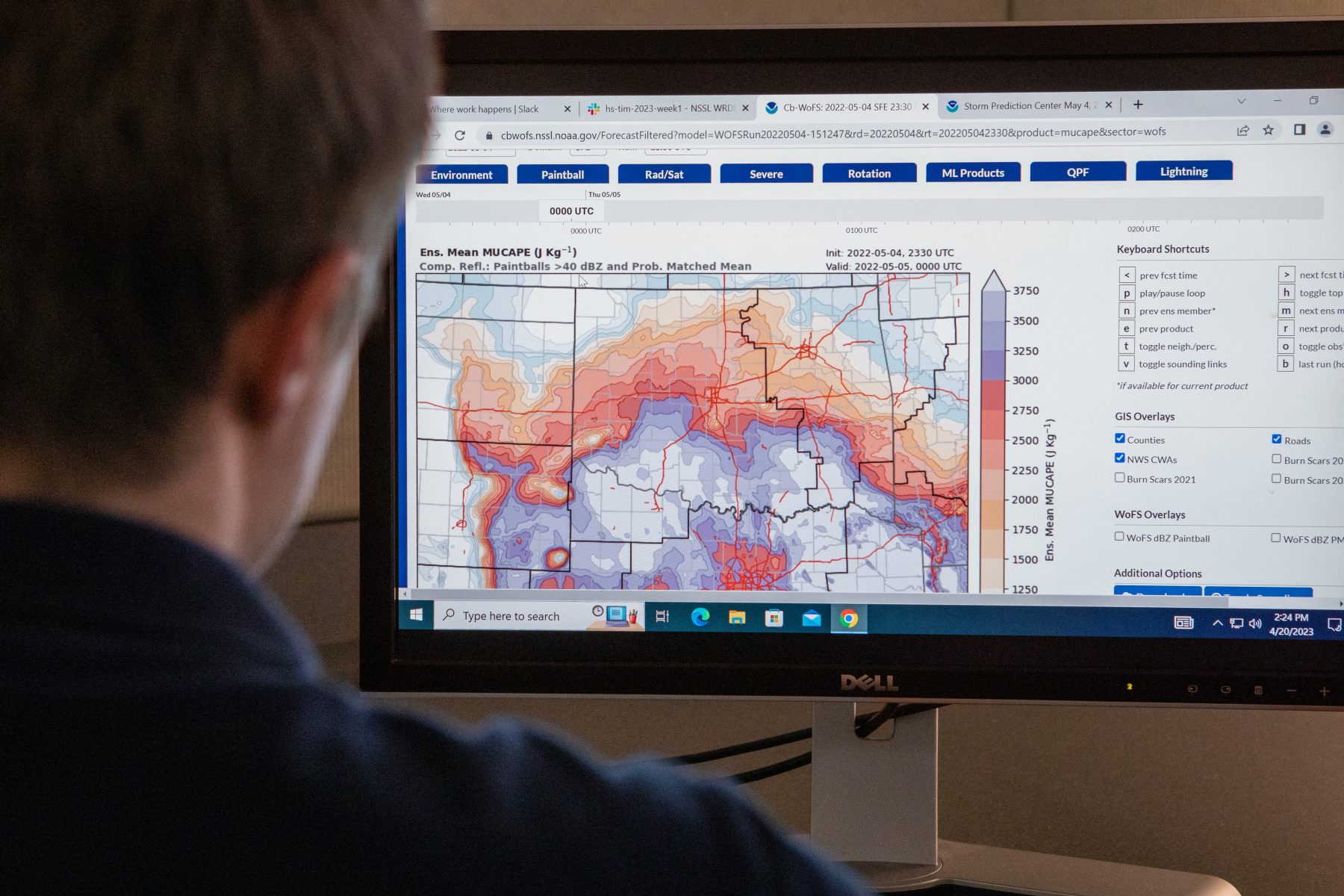
The Warn-on-Forecast System, a revolutionary new forecasting tool being developed by NOAA’s National Severe Storms Laboratory, seeks to equip forecasters with critical information between watches and warnings to allow them to offer longer lead times in the face of severe weather and tornadoes.
Since weather forecasters started issuing them, tornado and severe thunderstorm warnings have been based on observations. Whether from radar signatures or sightings by storm spotters out in the field, these observations confirm that tornadoes are imminent or ongoing. The resulting warnings give people in the path about 15 minutes to take shelter.
The Warn-on-Forecast System, a new tool developed and currently being refined by the NOAA National Severe Storms Laboratory (NSSL), seeks to change that paradigm and potentially increase the amount of lead time for the public from mere minutes to potentially an hour or more.
MIND THE GAP: WATCH TO WARNING
The NOAA Storm Prediction Center (SPC) in Norman, Okla., issues outlooks for severe weather days in advance of potential weather events. When conditions are right to produce severe weather—when all the ingredients are in place—the SPC issues a “watch” to signify that a certain type of severe weather is likely in the next two to eight hours for a given region. These watches can cover large geographic areas, spanning many counties or parts of multiple states, and typically last several hours.
When severe weather is observed by radar or storm spotters—when the ingredients are combined and turned into the final recipe—a warning is issued by the local National Weather Service (NWS) Forecast Offices.
The NWS has 122 weather forecast offices around the country. Each one is responsible for monitoring a specific area around the clock, 365 days a year. These highly trained and dedicated meteorologists issue warnings based on observations. A warning is an indication to seek shelter or take safety precautions against the specific mode of severe weather being warned.
These warnings are generally issued on the time scale of minutes and cover much smaller areas, generally a county or two.
The gap between when a watch is issued and when a warning is issued can often be several hours, with little new information available in that time frame. The Warn-on-Forecast System, a new tool developed by NSSL, is a potential solution to that gap.
“The SPC issues watches generally one to several hours in advance of severe weather,” said Todd Lindley, Science and Operations Officer for the NWS Norman Forecast Office. “There’s typically a time frame between when the watch is issued until warnings are issued for a specific site and during that period, that’s what we call the watch to warning gap.
“It’s a period where there’s a relatively minimal flow of information and customers and partners may be looking for information about how the storm threat is evolving in their local specific area hour-by-hour or minute-by-minute.”
By using numerical computer modeling and forecasts, rather than waiting to warn based on observation, Warn-on-Forecast equips forecasters with a tool to give people additional lead time or narrow down the risk area of imminent severe weather within that watch-to-warning gap.
“We’ve used Warn-on-Forecast for a lot of different events in our area,” said NWS Norman Forecast Office meteorologist Vivek Mahale. “We’ve used it for a tornado case. We’ve used it for large hail cases. One of the biggest things we’ve actually used it for is flash flooding.” He explained, “The goal of the National Weather Service is to have about an hour lead time for flash flood warnings. We’ve shown that by using the Warn-on-Forecast System, we’re able to achieve that.”
By using numerical computer modeling and forecasts, rather than waiting to warn based on observation, Warn-on-Forecast equips forecasters with a tool to give the public additional lead time or narrow down the geographic risk area of imminent severe weather.
A GAME CHANGING IDEA
According to NSSL scientist Lou Wicker, who has been involved with the Warn-on-Forecast System since its inception in 2003, in the early 2000s tornado warnings had increased to up to 15 minutes with the help of the nation-wide Doppler radar system which was completed in the early 90s. However, those lead times had plateaued and researchers and forecasters began to wonder why.
“It’s challenging to forecast from radar data beyond about 15 or 20 minutes in time,” said Wicker. “At that same time, computers had gotten powerful enough to start running numerical weather prediction models at grid spacings fine enough to resolve individual thunderstorms. So it seemed natural to start thinking about whether or not we could extend warning lead times by using these high resolution models.”
This new approach to warnings and storm information was a paradigm shift in the world of meteorology. By shifting from warnings based on current observations of ongoing storms to warnings based on future-looking computer model forecasts, there was potential for game-changing improvements to weather warnings.
“One of the wonderful things for me personally was when [Warn-on-Forecast] was presented to us by then NSSL director Jeff Kimpel,” said Wicker. “This vision of providing a longer warning for tornadoes and severe weather – Jeff characterized it as the weather equivalent of the Apollo program.
“That really resonated with us,” Wicker remembered. “I loved and was inspired by the space program and I remember seeing them walk on the moon. So that was a really great comparison when Kimpel talked about this being our Apollo moon shot project for weather forecasting. It was tremendously exciting to all of us.”
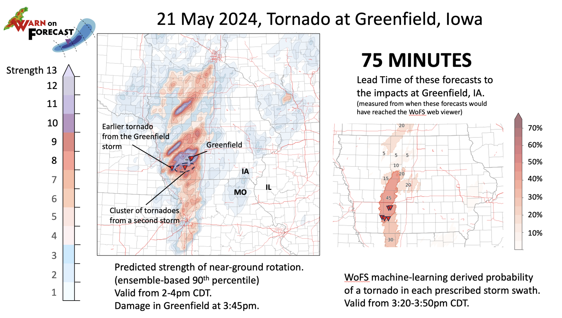
On May 21 2024 a violent tornado impacted the community of Greenfield, Iowa and surrounding areas. The Warn-on-Forecast System predicted strong probability of a tornado for the area with up to 75 minutes of advanced warning.
This type of information is invaluable to NWS forecasters as they make decisions on when and where to issue tornado warnings to give the public as much time as possible to protect themselves and their property.
TIME AND DECISIONS

The Gold Medal is the highest award of the United States Department of Commerce, presented by the Secretary of Commerce to federal employees for exceptional service for noteworthy or superlative contributions which have a direct and lasting impact. READ MORE
While additional lead time would be of benefit to everyone, there are those for whom this type of information is invaluable and potentially lifesaving. For some, seeking shelter from a tornado or severe storm is as simple as getting into a storm shelter at their home. For many others, it’s not so easy.
“Emergency managers know the groups in their community that are more vulnerable or that need additional time to make decisions,” said David Hogg, research associate for the Behavioral Insights Unit at NSSL and the Cooperative Institute for Severe and High-Impact Weather Research and Operations (CIWRO).
“That can be a group like a hospital. If you’re going to evacuate a hospital or move patients, that takes a lot of time,” Hogg explained. “Or after school with bus routes where an entity may have people that are in a vulnerable position where they need additional time to find shelter. Outdoor events where you have a large stadium, a concert venue, something like that, where people are away from home, away from a sturdy shelter, and then they’re more vulnerable, they’re more susceptible to those kinds of impacts from severe weather.”
Given those vulnerabilities, additional information, whether directly from official NWS warnings or from other emergency management services can be potentially life saving.
“We have heard from emergency managers working with their National Weather Service partners that they have been given information leading up to events that have helped them really make decisions, preparing for the impact of that event.
“And so we’ve seen with tornadoes where emergency managers have used information from Warn-on-Forecast to open shelters, maybe at an earlier time than they otherwise would have. So we’re seeing more and more of these stories where it really is helping them make those pre-event decisions.”
PROTECTING LIVES AND PROPERTY
Ultimately the goal of Warn-on-Forecast is to bridge the information gap between NWS watches and warnings. By equipping forecasters with additional information about the probability for and potential location of severe weather, Warn-on-Forecast allows for longer warning lead time for flooding, severe weather and tornadoes; changing the scale from mere minutes to potentially hours.
Armed with that kind of lead time, even vulnerable populations or institutions are better able to seek shelter and make decisions to protect themselves and those in their charge. 


