

Short-term Ensemble Prediction of Tornadoes in Landfalling Tropical Cyclones
T. Jones, P. Skinner, A. Fierro, T. Rinehart, K. Knopfmeier (Univ. Oklahoma/CIMMS)
Plans:
- Continue development of the Warn-on-Forecast system (WOFs) in regards to forecasting rotating supercells and high wind threats generated by landfalling tropical cyclones.
- Add the capability to assimilate Global Lightning Mapper (GLM) data into the WOFs system to provide additional data on strong convection over ocean regions where radar data are not available. GLM data will also be used over land where radar outages occur due to the impacts of the tropical cyclone.
- Generate probabilistic short term (0-6 h) forecast products emphasizing the threats for supercell rotation, hurricane forecast winds, and heavy precipitation. Separate products will be created for each threat and combined “multi-threat” plots will also be tested.
- Run WOFs in real-time for landfalling tropical cyclones if resources permit and distribute output to relavent operational partners.
Recent executive summary:
The goal of this project is to utilize the Warn-on-Forecast System (WoFS) to generate short-term (0-6 h) probabilistic forecasts of tornado producing storms spawned by landfalling tropical cyclones. Other tropical cyclone threats such as high winds near the eye and heavy precipitation are also considered. The WoFS is a storm-scale resolution (3 km) ensemble data assimilation and forecasting system that has been used in real-time for severe weather forecasting by the Hazardous Weather Testbed, Storm Prediction Center, Weather Prediction Center, and multiple National Weather Service offices. Testing of the WoFS has been performed on several archived tropical cyclone cases from 2017 (Harvey and Irma) and 2018 (Michael) with very successful results after tuning aspects of the system for a tropical environment. One focus of this work has been to create visualization tools suited for tropical cyclone applications. These products include minimum sea level pressure, sustained winds and gusts, rainfall rate, and the likelihood of rotating supercells within rainbands. Figure 1 shows an example of several of these products combined for a 6 hour forecast initiated near the landfall time of hurricane Michael on 10 October 2018.
Starting in the fall 2019, the WoFS was utilized in realtime for tropical cyclone applications in severe weather forecasts associated with hurricane Dorian as it moved up the east coast of the United States. Additional operational utilization of this system is expected during the 2020 tropical cyclone season in combination with NWS and other partners. Continued development of the system is occurring with efforts to increase horizontal resolution, assimilate GOES-R lightning flash observations, and creating additional visualization tools to be used by both forecasters and researchers.

Formal publications and reports:
- (None)
Project commenced Sept 2019
This page updated 2020_11_11
Exploring the Influence of Surface Heterogeneities on Low-level Vertical Vorticity and Polarimetric Radar Signatures in Idealized Quasi-Linear Convective Systems
K. Lombardo, M. Kumjian (Penn State Univ.)
Plans:
- Characterize the influence of orographic heterogeneities on QLCS structure, evolution, and the development of vertical vorticity.
- Characterize the influence of nocturnal thermodynamic heterogeneities on QLCS structure, evolution, and the development of
- near-surface vertical vorticity.
Recent executive summary: (Read…)
Formal publications and reports:
- (None)
Project commenced Sept 2019
This page updated 2020_11_11
Geospatial Threat Personalization and its Influence on Warning Risk Perception and Protective Actions
K. Sherman-Morris (Mississippi State Univ.); J. Senkbeil (Univ. Alabama)
Plans:
- “[The project] will examine individuals’ personalized risk area in a tornado warning using a two-phase approach that includes a cognitive mapping strategy.”
- “The project will answer three broad research questions regarding 1) the geographic components that define a person’s personalized risk area, 2) how personalized risk area differs based on individual characteristics or characteristics of the warnings, and 3) the influence of personalized risk area vs. an objectively mapped risk area on risk perception.”
- “[The project plans] to first conduct in-person interviews incorporating a sketch-map task. This will be followed by geospatial analysis of participant responses.”
- “A second phase will consist of an online survey that will allow us to further compare the geographic dimensions of warning risk personalization among a larger sample of residents from urban vs. rural areas.”
Recent executive summary: (None)
Formal publications and reports:
- (None)
Project commenced Sept 2019
This page updated 2020_07_09
Defining the capabilities of boundary layer profiling systems for operations in the southeastern United States
T. Bell, E. Smith, M. Coniglio, S. Waugh (NOAA/NSSL); D. Turner (NOAA/ESRL)
Plans:
- Observation data will be used to evaluate the boundary layer profiling platforms themselves. This means we will use these data to try to learn how to best deploy boundary layer profilers, both as individual platforms and as a network, and we will evaluate the existing retrieval methods across a range of environmental conditions to improve retrievals and quantify observation error.
- Observation data will be used to evaluate the existing tools often used in public forecast and warning operations. Since the boundary layer profile observations from VORTEX-SE have higher temporal resolution than most standard platforms, these data can be used to evaluate how well tools like short-term model predictions and the Storm Prediction Center Surface Objective Analysis represent the rapidly evolving boundary layers and associated environmental parameters.
- Observation data will be used to document rapidly evolving pre-convective environments in the southeastern US. This effort will include comparing observed boundary layer evolution to recent findings from numerical studies, quantifying the magnitude of rapid boundary layer evolution in low instability and high shear environments.
Recent executive summary:
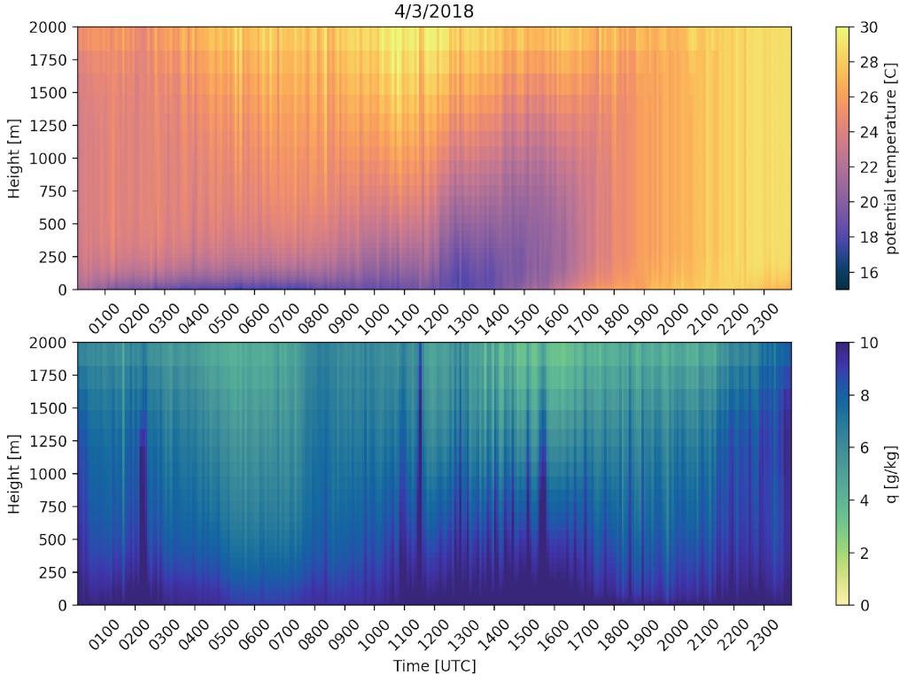
Using state-of-the-art observation platforms, this project aims to define the capabilities of boundary layer profiling systems for operations in the southeastern United States. A large portion of the first 6-months of work has been spent on gathering, bias correcting, and reprocessing data from all previous years of the VORTEX-SE campaign (see Fig 1 for example data). The thermodynamic retrieval framework was converted into a more flexible and open-source tool to facilitate rapid development and deployment without software license constraints. In the next 6 months, the data that have been gathered and compiled will be used to start documenting boundary layer characteristics and evolution in the southeastern United States and to understand how well commonly used forecast and warning operations tools represent boundary layer features common in this region.
Formal publications and reports:
- (None)
Project commenced Sept 2019
This page updated 2020_11_11
Environmental and Storm-Scale Characteristics of Tornado-Producing Rainbands within Landfalling Tropical Cyclones
S. Trier, G. Bryan (NCAR)
Plans:
- Determine the environmental conditions for different types of landfalling TC tornado occurrence (including varying distances from the coast, and differing TC strengths). This will be accomplished by constructing composites of environmental conditions, using model reanalysis data as the primary input.
- Examine structure and evolution of convection, and determine possible TC-tornado surrogates, in convection-allowing simulations for these different types of TC-tornado cases (above). The primary tool used for examination will be a small WRF-model ensemble based on a subset of NOAA HREF members.
- Clarify processes that favor or hinder near-surface mesocyclone
Recent executive summary:
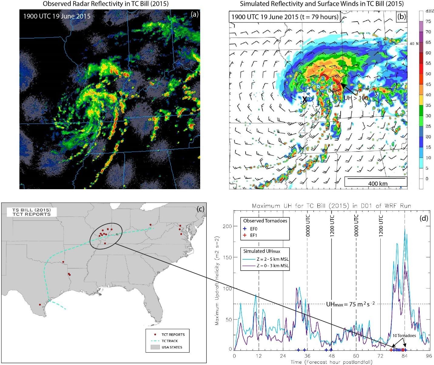
The ultimate goal of this VORTEX-SE-4 project is to improve forecasts of tornado threat from landfalling tropical cyclones (LTCs) in southeastern U. S. coastal regions, and adjacent inland locations. During this reporting period we used both analysis of observations and simulations from a research numerical model, configured in a manner similar to the High-Resolution Ensemble Forecast (HREF) in use at NOAA. We completed our analysis of categories of environments in which tropical cyclone tornadoes (TCTs) form, by averaging the meteorological conditions in TCT environments for multiple cases both near the coast and at locations well inland. Both of these composites, together with composites from three other TCT environments (discussed in previous reporting) are expected to help raise awareness for severe weather outlooks (on timescales of up 36 hours) and have been shared with collaborator Roger Edwards (lead forecaster at NOAA SPC).
TCTs are significantly more common near the coast in the first day after TC landfall. However, significant tornado outbreaks can occur well inland and several days after landfall. Forecasting inland TCTs can present a significant forecasting challenge because of their lesser overall frequency than TCTs near the coast, their environmental conditions can differ from the more common near-coast TCTs, and because even the highest-resolution operational models are unable to explicitly simulate tornadoes in general. The most extensive analysis performed during this reporting period was for a simulation of Tropical Storm Bill (2015). Figure 1b indicates that both the location and overall pattern the model-simulated radar-reflectivity structure compares well with observations (Fig. 1a) when the LTC was located ~1000 km inland from its landfall along the Texas Gulf Coast, and was producing numerous observed afternoon tornadoes in lower Ohio River Valley region (Fig. 1c). The updraft helicity (UH), which is the product of the vertical velocity and the vertical component of the relative vorticity (rotation about a vertical axis) has often been used to characterize the strength of mesocyclones, which are thunderstorm-scale circulations in which tornadoes are often embedded. Previous research has examined mesocyclones associated with central Plains supercell thunderstorms that often produce tornadoes. However, comparatively less research has been conducted on mesocyclones associated with TCTs, and which layers above ground the simulated mesocyclone strength, as indicated by UH, best correlate with tornado occurrence in TCTs. Figure 1d indicates daily peaks in UH in both the 0-3 km and 2-5 km layers occurring with daytime surface heating and more active thunderstorms within the LTC. The simulated UH peaks are clearly strongest 72 hours after Tropical Storm Bill’s landfall, when the greatest number observed tornadoes occurred (Fig. 1d), mostly in the vicinity of southern Illinois (Fig. 1c). This is attributed to the interaction of the remnant TC circulation when it encounters a surface front over the Ohio River Valley, which enhances the vertical shear, an environmental quantity that is favorable for tornadoes in our composite analysis (previously reported). Since even the highest-resolution forecast models are not able to explicitly predict tornadoes, efforts are underway where we employ a statistical approach to determine threshold UH values and optimal layers containing UH for use as a surrogate from model output for tornado prediction in LTCs.
Formal publications and reports:
- (None)
Project commenced Sept 2019
This page updated 2020_11_11
Eye-Tracking the Storm: Information Processing of Visual Risk Communication
J. Sutton, L. Fischer (Univ. Kentucky)
Plans:
- This project uses an experimental scenario to understand how people physically, cognitively, and emotionally engage with risk information about a tornado threat.
- We use eye tracking to measure visual attention to images about increasing risk. We identify what people look at, when, and for how long.
- We use pre- and post- experiment surveys to measure prior experience, risk perceptions, affect, and message processing.
- The results of this research will aid in the design of messages that communicate risk using both text and visual information.
Recent executive summary: (Read…)
Formal publications and reports:
- (None)
Project commenced Sept 2019
This page updated 2020_07_09
VORTEX-SE: Characterization of microphysical processes in potentially tornadic Southeast U.S. storms via polarimetric radar – disdrometer – lightning synthesis
R. Tanamachi, D. Dawson (Purdue Univ.); E. Bruning, C. Weiss (Texas Tech Univ.)
Plans:
- (Not available)
Recent executive summary:
Our analyses to date have focused on careful quality control of lightning data and alignment of storm cells in the lightning data with StickNet measurements of surface temperatures and winds, alongside weather radar and high resolution simulations. We have begun prototyping analysis methods using the 31 March 2016 storm system that moved across north Alabama and Southern TN. Complex storm motions and multiple storm cells in the vicinity of each observing site will require careful analysis of storm cell motions to properly assess how the near-surface and lightning measurements covary with precipitation processes. A combined modeling and observation synthesis will allow for us to perform physical attribution and gain understanding of forecast techniques that will apply generally.
Formal publications and reports:
- (None)
Project commenced Sept 2019
This page updated 2020_11_11
VORTEX-SE: Quantifying the Influence of Sea-Surface Temperature Uncertainty on Cool-Season Severe Weather Event
C. Evans (Univ. Wisconsin Milwaukee)
Plans:
- Severe weather events in the southeast United States in high-shear, low-CAPE environments are characterized by rapid local generation of surface-based CAPE immediately preceding severe thunderstorm initiation. The basic thermodynamic properties of the associated inflowing air parcels are modulated by surface heat exchange at the atmosphere-ocean interface over the Gulf of Mexico and western Atlantic Ocean over the preceding 24 h.
- Our guiding hypothesis is that forecasts of cold-season southeast United States severe weather events in high-shear, low-CAPE environments are sensitive to the modeled sea-surface temperature representation, such that the practical predictability of these events at lead times of 6-24 h is limited by inaccuracies in modeled surface heat exchange at the atmosphere-ocean interface.
- The proposed research has three components:
- High-resolution numerical simulations of high-impact cold-season southeast United States severe weather events identified by NWS WFO Tallahassee, FL collaborators in which the sea-surface temperature initialization is varied (year 1).
- Ensemble numerical simulations for one event, with the aim of quantifying how forecast sensitivity to sea-surface temperature compares to that associated with initial atmospheric uncertainty and turbulence parameterization (year 2).
- Forecast exercises using simulation outputs involving NWS WFO Tallahassee, FL, Mobile, AL, and Slidell, LA meteorologists to evaluate the practical significance (utility to the forecast process) of the research findings (years 1-2)
Recent executive summary:
To test our motivating hypothesis that forecasts of cold-season southeast United States severe- weather events in high-shear, low-instability environments are sensitive to atmosphere-ocean energy exchange over the Gulf of Mexico and western Atlantic Ocean, we have produced six high-resolution numerical forecasts with varying sea-surface temperature representations for each of eight southeast United States severe-weather events. We are still interrogating the forecast output; however, a preliminary analysis for one case (7 March 2008; figure below) suggests that most simulation differences are small and confined to the inherently less-predictable storm scales.
The eventual operational applications of this research are two-fold. For operational forecasters, research findings will provide for improved interrogation of short-range model guidance for high-shear, low-CAPE severe-weather events. For model developers, research findings will inform how sea-surface temperatures are represented within thunderstorm-resolving models.
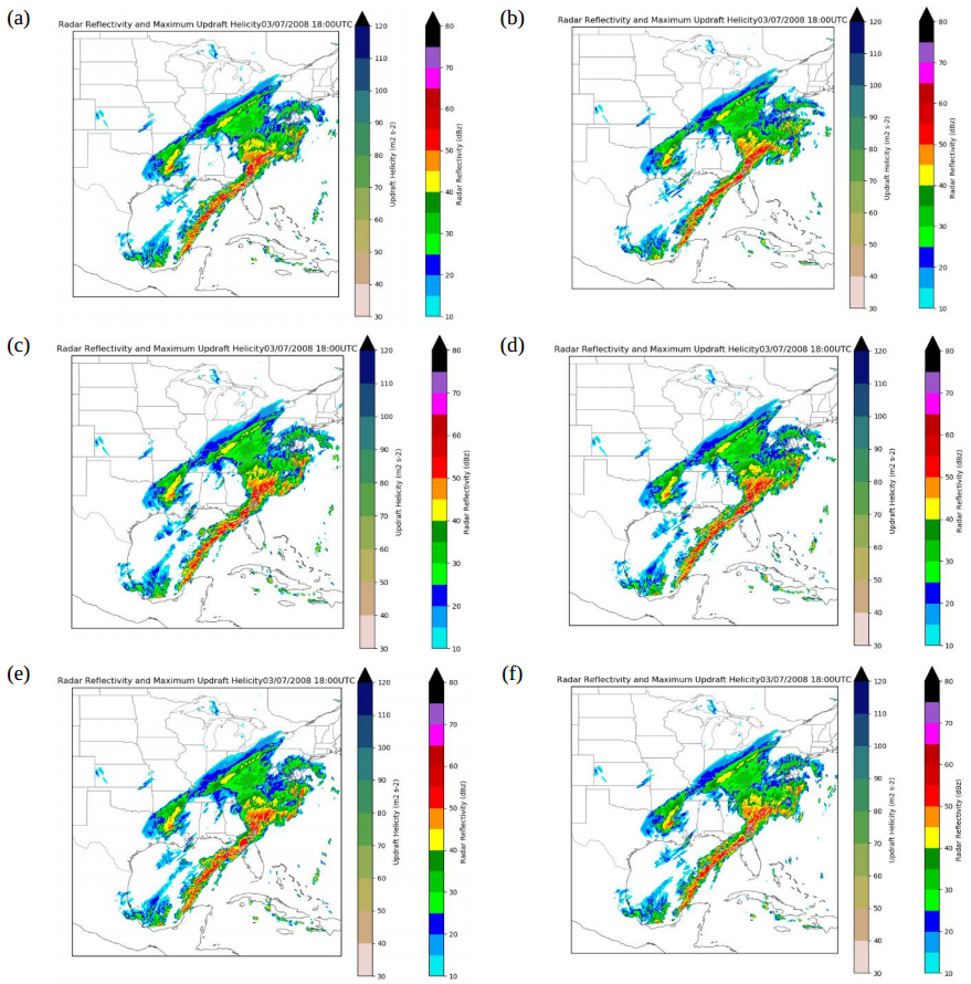
hourly maximum 2-5 km above ground level updraft helicity (m2 s-2; shaded per the leftmost
color bar) valid at 1800 UTC 7 March 2008 from the (a) control, (b) Fleet Numerical
Meteorology and Oceanography Center, (c) Group for High-Resolution SST, (d) NOAA
Optimum Interpolation, (e) Remote Sensing Systems, and (f) US Naval Oceanographic Office
SST-based simulations of the 7 March 2008 southeast United States severe-weather event.
Formal publications and reports:
- (None)
Project commenced Sept 2019
This page updated 2020_11_11
Evaluation of Structural Vulnerability in the Southeast United States Using High-Resolution Tornado Simulations with Buildings and Terrain
D. Bodine, A. Reinhart (Univ. Oklahoma), F. Lombardo (UIUC)
Plans:
- Understand and reduce structural vulnerability to tornadoes.
- High-resolution (1 – 1.5m) large-eddy simulations of tornadoes.
- Embed variety of residential structures and patterns of structures.
Recent executive summary:
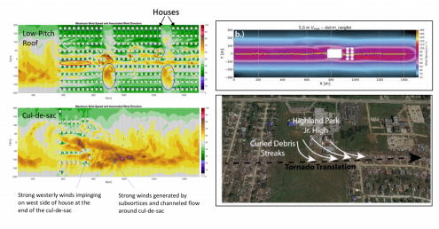
Tornadoes produce intense winds and loft large amounts of flying debris, which can severely damage residential structures. In order to better protect life and property, the characteristics of the tornado’s winds striking buildings must be understood in order to design more resilient buildings. This study focused on how different types and layouts of residential buildings affect the winds in tornadoes and damage potential.
To address this challenge, this study uses high-resolution computer simulations of tornadoes in residential areas to understand the distribution of tornado winds for common residence types in the Southeast United States. Simulations of different neighborhood layouts and different house types are conducted, and the neighborhood layout is found to impact the characteristics of the winds affecting each house. The wind direction, in particular, is found to become focused along the streets where winds are channeled along the rows of houses and between the gaps in houses in a row. In some cases, the focused wind directions may lead to increased damage potential, such as a house at the end of a cul-de-sac, where significant tornado damage is often observed. In other cases, the channeling of flow along streets might provide some sheltering effect for structures who are in the wake of a building upstream. It is caveated that the protective effects assume the structures remain intact and no debris is generated.
In addition to neighborhood layout simulations, interactions between large buildings and nearby residential structures are examined, finding that significant intensification occurs downstream. Evidence for such downstream intensifications is seen as well in past tornado damage surveys, suggesting that structures downstream from large buildings might be more vulnerable to damage. The findings from the project will inform structural engineering recommendations for building codes to reduce property damage and loss of life. In addition, our findings have been shared with the Morristown, TN Weather Forecast Office to discuss how these findings affect societal vulnerability to tornadoes in the Southeast United States.
Formal publications and reports:
- (None)
Project commenced Sept 2019
This page updated 2020_11_11
Assessing scale-aware PBL parameterizations at WoF scales
J. Gibbs, C. Potvin, J. Lawson (NOAA/NSSL/CIMMS)
Plans:
- Objective: Use sophisticated LES codes to develop/improve scale-aware PBL schemes.
- Objective: Implement new scale-aware PBL schemes in the WRF model. Using the NSSL Warn-on-Forecast System, generate ensemble forecasts with traditional and scale-aware PBL schemes over a range of SE U.S. cases at 1-3-km grid spacing.
- Objective: Evaluate impact of scale-aware PBL schemes on SE U.S. ensemble forecasts using a diverse set of traditional and novel verification methods.
Recent executive summary: (None)
Formal publications and reports:
- (None)
Project commenced Sept 2019
This page updated 2020_07_09
Evaluate radar wind profilers with RASS for characterizing Southeast severe storm environments
J. Wilczak (NOAA/ESRL)
Plans:
- Deploy one 915 MHz profiler with RASS, and one colocated surface station, in the Southeast by 1 November 2019
- Deploy one 445 MHz profiler with RASS, and one colocated surface station, in the Southeast by 1 November 2019.
- Evaluate the suitability of these instruments for NCTS in typical Southeast severe storms environments.
Recent executive summary: (None)
Formal publications and reports:
- (None)
Project commenced Sept 2019
This page updated 2020_07_09
VORTEX-SE 2020 Field Campaign (Risk Reduction) Activities: Observations of the Environment and Evolution of Non-Classical Tornadic Storms
K. Knupp (Univ. Alabama Huntsville)
Plans:
- “…develop a ‘clear-air’ [ARMOR] radar climatology that will provide information on the range and height of clear air backscatter (equivalent radar reflectivity factor, Z e ), particularly during the cool season months (Nov-Mar) when insect concentrations are typically low.
- “…develop cloud base frequency vertical profiles that can be used to define the optimum flight altitude for [airborne] measurements using available [airborne] lidar systems.”
- “…classification of NCTS types and typical behaviors based on 12 years of ARMOR and adjacent WSR-88D, and MIPS profiler data.”
- “…continue evaluation of citizen weather stations (CWS), and their integration into the ongoing “Alabama mesonet” composed of a variety of surface weather stations.”
Recent executive summary:
This project consisted of data collection, and analysis of previously collected data. During the period December 2019 through April 2020 UAH deployed mobile facilities to form mesoscale networks for potential severe weather events over central to NW Alabama, and to acquire measurements of severe storms and their adjacent environment. The 2019-2020 cold (winter) season had an above-average number of severe weather events, and all systems performed well to provide a rich data set on the environment ahead of linear storm systems or squall lines, also known an quasi-linear convective systems (QLCS).
Newly started data analysis tasks included examination of the relation between Doppler radar velocity measurements and tree damage at close range (2-20 km). This unique data set will help validate new techniques to assess tornado intensity based on the extent of tree damage. We are also investigating the spatial and temporal variability of the boundary layer adjacent to severe storms, in order to improve our understanding of boundary layer processes and how these processes may play a role in generation of strong winds and tornadoes. This multi-faceted task has the longer-term goal of improving tornado warnings having longer lead times with greater accuracy.
Formal publications and reports:
- (None)
Project commenced Sept 2019
This page updated 2020_07_09
Surveys to analyze suitability of five subregions in the Southeast for intensive field observations (contract)
M. Biggerstaff (Univ. Oklahoma); contractor chosen via federal contract opportunity in the Summer of 2019.
Plans:
- Survey the following geographical subregions: Wiregrass (near Dothan, AL), Black Belt (Columbus MS toward Tuscaloosa, AL), Tennessee Valley (west of Huntsville), Northern Mississippi Delta (northwest MS, eastern AR), and Southern Mississippi Delta (eastern LA and far western MS)
- Assess the availability of sites for mobile Doppler radars, profilers, Lightning Mapping Array receivers, and sticknet surface instruments.
- Provide a report to the Non-Classic Tornadic Storms planning committee for input to an experiment plan, and to the VORTEX-SE Program Manager and Coordinating Scientist.
Recent executive summary: (None)
Formal publications and reports:
- (Pending… link to contract report)
Project completed early 2020
This page updated 2020_07_09
Investigating the longevity of QLCS mesovortices in the southeast United States
T. Galarneau (NOAA/NSSL/CIMMS)
Plans:
- Investigate the ability of short-term (0-6 h) convection-allowing model forecasts to predict the pre-storm environment and long-lived mesovortices associated with quasi-linear convective systems (QLCSs) in the southeast U.S.
- Determine the model physical processes that are governing the accurate prediction of the pre-storm environment and convective mode.
- Identify 5-10 QLCS cases in VORTEX-SE domain and characterize pre-storm environment using available surface and upper-air observations and 0-h high-resolution rapid refresh (HRRR) analyses and track mesovortices using WSR-88D observations.
- Examine 0-6 h forecasts from the operational HRRR and experimental National Severe Storms Laboratory Warn-on-Forecast system (WoFS) and compare convective mode and pre-storm environment to observations.
- Rerun WoFS forecasts for select cases and output temperature, moisture, and momentum tendencies from the model physical parameterizations to help determine which model physical processes the forecast pre-storm environment is most sensitive to.
Recent executive summary: (None)
Formal publications and reports:
- (None)
Project commenced July 2019
This page updated 2020_07_09
Linking Survivor Stories to Forensic Engineering: An Inter-Science
Approach to Reducing Tornado Vulnerability in Residential Shelters
D. Ladue (Univ. Oklahoma/CIMMS), F. Lombardo (U. Illinois), D. Roueche (Auburn Univ.)
Plans:
- (Pending…)
Recent executive summary:
This project uniquely integrates detailed accounts of tornado survivors’ experiences with analysis of damage to the home they were in, contextualized within the broader tornado impacts and wind field. Our team first piloted our research plan after the 3 March 2019 Lee County “Beauregard” Alabama tornado using quick response funding from NOAA, interviewing survivors at 27 homes. During the current project period we conducted follow-up interviews with eight of our 27 Alabama participants and added two participants. The project team again deployed on the 3 March 2020 Nashville and Cookeville tornadoes that struck late at night when most people were sleeping. Over a three-day period we conducted field research, speaking with survivors at 14 home sites in the long-track “Nashville” tornado path and 12 home sites in the “Cookeville” tornado path. We also collected vehicle-mounted and UAV imagery of the damage areas. We will analyze the survivor accounts, forensic damage assessments, and imagery to develop a holistic perspective of the tornado characteristics, performance of the watch/warning system from the viewpoint of survivors, structural performance of the homes they were in, and actions that either contributed to or failed to protect life safety.
Formal publications and reports:
- (None)
Project commenced July 2019
This page updated 2020_07_09