

Modulation of convective-draft characteristics and subsequent tornado intensity by the environmental wind and thermodynamics within the Southeast U.S.
R. Trapp (Univ. Illinois)
Progress and tentative outcomes:
- Identified 76 HSLC and HSHC events and manually analyzed radar data.
- Tornado EF rating increases with increasing antecedent mesocyclone width.
- In QLCS the relationship is stronger when using objective radar-based vortex intensity estimates instead of EF, a possible symptom of biased EF estimates in the cli
Recent executive summary:
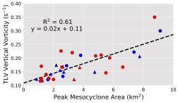
Although tornadoes produced by quasi-linear convective systems (QLCSs) generally are weak and short-lived, they have high societal impact due to their proclivity to develop over short time scales, within the cool season, and during nighttime hours. Precisely why they are weak and short lived is not well understood and motivated this work. Toward this end, idealized numerical simulations of tornadic QLCSs were performed to determine the controls of tornado intensity. Generally, increased environmental hodograph curvature and thus environmental shear in these simulations resulted in stronger, longer-lived tornadic like vortices (TLVs). A strong correlation between low-level mesocyclone width and TLV intensity was identified (R2 = 0.61) (see figure) with a weaker correlation in the low-level updraft intensity (R2 = 0.41). The tilt and depth of the updraft were found to have little correlation to tornado intensity. A forcing decomposition revealed that the QLCS cold pool played a direct role in the development of the low-level updraft. Specifically, it provided the benefit of additional forcing for ascent but also had potentially deleterious effects on both the low-level updraft and near-surface rotation. The negative impact of the cold pool ultimately serves to limit the persistence of rotating updraft cores within the QLCS. The basic relationships between TLV intensity and environmental wind shear can be incorporated into routine NWS forecast operations.
Formal publications and reports:
- https://doi.org/10.1175/WAF-D-19-0099.1. Trapp, R.J., G.R. Marion, and S.W. Nesbitt, 2018: Reply to “Comments on ‘The regulation of tornado intensity by updraft width’”. Journal of the Atmospheric Sciences, 75, 4057–4061.
- Marion, G. R., and R. J. Trapp, 2019: The dynamical coupling of convective updrafts, downdrafts, and cold pools in simulated supercell thunderstorms. Journal of Geophysical Research-Atmospheres, 124, https://doi.org/10.1029/2018JD029055.
- Sessa, M. F., R. J. Trapp, and J. Einbinder, 2020: Observed relationship between tornado intensity and pre-tornadic mesocyclone characteristics, Weather and Forecasting, https://doi.org/10.1175/WAF-D-19-0099.1.
Project completed October 2020
This page updated 2020_11_11
Exploration of Terrain Effects on Tornado and Supercell Dynamics in the Southeast United States
D. Bodine (Univ. Oklahoma/ARCC); T. Reinhart (Univ. Oklahoma/CIMMS); F. Lombardo (Univ. Illinois)
Progress and Tentative Outcomes:
- “…completed an extensive suite of high-resolution simulations of tornadoes traversing different surface roughnesses and terrain at different swirl ratios and translation speeds.” This research is tentatively identifying changes in tornado intensity owing to terrain variations.
- Preliminary CM1 simulations show changes in supercell strength and motion when traversing terrain features.
Recent Executive Summary:
The topography of the Southeast United States includes extensive regions of mountains, plateaus, valleys, and other topographic features. While several past studies have suggested that these topographic features may impact the likelihood of tornado formation and the resulting intensity and areal extent of the tornado’s winds, a more comprehensive study is needed to understand what topographic effects can be generalized and how significant these topographic effects are. The project team used high-resolution computer simulations of tornadoes and developed software to allow the simulated tornadoes to pass over a wide range of topographic features, including topographic features commonly observed in the Southeast United States.
During this reporting period, the team worked with the Morristown, Tennessee Weather Forecast Office (WFO) on an observation and simulation study of the 13 April 2018 Mountainburg, Arkansas tornado. The tornado developed at the opening of a river valley and tracked through the river valley, eventually ascending a sharp ridge where it dissipated over a slope with a vertical elevation change of 250 m in 2 km (Figure 1a,b). Using NEXRAD data and the damage survey, our collaborative analysis showed that the low-level rotation signature weakened when ascending the ridge and the circulation became broader and more poorly defined. We explored other factors explaining why the tornado would have dissipated, such as the updraft weakening or an occlusion occurring, and the evidence suggests the parent storm’s updraft remained intense. Using computer simulations with similar terrain, we found that the tornado did weaken as it ascended the ridge and the circulation remained broad and weak on top of the ridge (Figure 1c). Between this case and many simulations considered, the findings show evidence of terrain effects on tornado wind speeds that forecasters can look for on damage surveys and can provide guidance for engineering risk assessments and building codes.
Formal publications and reports:
M. Satrio, D. Bodine, A. Reinhart, T. Maruyama, and F. Lombardo, 2020: Understanding how complex terrain impacts tornado dynamics using a suite of high-resolution numerical simulations. J. Atmos. Sci, 77, 3277–3300, https://doi.org/10.1175/JAS-D-19-0321.1.
(2 articles in preparation and 7 additional informal publications and presentations)
Project in progress July 2019
updated 2020-11-11
An investigation of the effects of complex topography on storm environments, near-surface wind profiles in and near storms, and tornado vulnerability in the southeastern U.S., using existing data and observations from the VORTEX-Southeast field campaign
P. Markowski, Y. Richardson (Penn State Univ.)
Progress and Tentative Outcomes:
- Assembled climatology of HRRR forecast parameters to study effects of complex terrain 2013-2017 Feb-Sept.
- Tentative: numerous generally subtle possible influences of terrain on severe storm forecast parameters have been identified.
- Extensive analysis of boundary layer wind profiles from northern Alabama completed, and departure from theoretical profiles assessed. Large departures from theoretical predictions are common.
- A climatology of Southeast tornadoes and associated forecast parameters has been completed.
Executive Summary:
A team of Penn State researchers examined various aspects of tornado-producing storms, their prediction, and their societal impacts in the southeastern U.S. It was found that some terrain features can make atmospheric conditions more favorable for tornadoes; however, the effects are extremely localized and difficult to generalize, as they depend on complex interactions between the large-scale weather pattern and small-scale terrain features. It was also found, from special field observations collected in northern Alabama, that the representation of wind fields near the ground in computer simulations of thunderstorms is in poor agreement with reality. The deficiency likely will need to be remedied in order for substantial gains in the skill of computer-generated forecasts of localized storm hazards to be realized. Lastly, the most dangerous and deadly tornadoes in the southeastern U.S. are well-warned. Whether the relatively high rates of death associated with these tornadoes could be improved by longer warning lead times, reductions in false alarms, or improved communication of warnings and preparedness actions bears further investigation.
Formal publications and reports (3 additional informal publications and presentations)
Anderson-Frey, A.K., Y.P. Richardson, A.R. Dean, R.L. Thompson, and B.T. Smith, 2019: Characteristics of Tornado Events and Warnings in the Southeastern United States. Wea. Forecasting, 0, https://doi.org/10.1175/WAF-D-18-0211.1
Anderson-Frey, A.K., Y.P. Richardson, A.R. Dean, R.L. Thompson, and B.T. Smith, 2018: Near-Storm Environments of Outbreak and Isolated Tornadoes. Wea. Forecasting, 33, 1397–1412, https://doi.org/10.1175/WAF-D-18-0057.1
Anderson-Frey, A.K., Y.P. Richardson, A.R. Dean, R.L. Thompson, and B.T. Smith, 2017: Self-Organizing Maps for the Investigation of Tornadic Near-Storm Environments. Wea. Forecasting, 32, 1467–1475, https://doi.org/10.1175/WAF-D-17-0034.1 *
* not supported by VORTEX-SE but relevant to subsequent research
Project completed October 2020
updated 2020-11-11
How Forecasters decide to warn: Insights on tornado risk communication from the Southeast U.S.
B. Liu, A. Atwell Seate (Univ. Maryland START)
Progress and Tentative Outcomes:
- New insights being solidified in tornado warning decision-making, relationship-building with key NWS partners, risk communication strategies, and training needs in the areas of risk communication and social media.
Recent executive summary:
This project’ primary objective was to understand how National Weather Service (NWS) forecasters in the Southeast U.S. make tornado warning decisions, where they need more information, how they share information, and how they build relationships with local partners and community members in light of today’s competitive media environment. The study also investigated differences between NWS forecasters in terms of their risk communication decision-making processes. To meet our objective, we conducted 13 phone interviews with NWS forecasters from three Weather Forecast Offices in the Southeast U.S. We then conducted a multi-sited rapid ethnography in the same three Weather Forecast Offices. In the final research stage, we surveyed 119 forecasters and members of management operating in NWS offices located in the Southern and Central regions of the U.S. The results provide insights into operational informational needs and factors influencing the decision to warn about tornadoes (e.g., tornado warning philosophies, office culture, relationships, and technology preferences). The project also uncovered multiple new risk communication strategies not currently found in the risk communication literature (e.g., visualize the risk and translate science) as well as factors that influence decisions to warn. Overall, the findings provide insights into operational informational needs and factors influencing the decision to warn about tornadoes.
Formal publications and reports (None; 7 additional informal publications and presentations)
Project in progress July 2019
updated 2020-07-11
VORTEX-SE: Improving radar wind retrievals and understanding local environmental influences on downdraft processes in potentially tornadic storms in the Southeast United States
J. Wurman, J. Marquis, K. Kosiba (Center for Severe Weather Research)
Progress and Tentative Outcomes:
- Explored the use of mobile Doppler VAD wind profiling to augment other sources; found good agreement with other sources.
- Continuing to explore modifications of traditional dual-Doppler analyses in the presence of terrain features, including Froude number effects to adjust vertical velocity near the ground.
Formal publications and reports (None; two additional informal publications and presentations)
Project in progress July 2019
updated 2019-07-17
Collaborative Research: Using Vulnerability as Empirical Data to Improve Forecast and Warning Services
D. LaDue, J. Friedman (Univ. Oklahoma); L. Myers (Univ. Alabama)
Progress and Tentative Outcomes:
- Brief Vulnerability Overview Tool (BVOT) beta-tested in NWS office in Alabama during a severe weather event.
- BVOT shared with Alabama emergency managers to assess response.
- BVOT moving forward via non-VORTEX-SE grant and Hazardous Weather Testbed testing.
- Objective: “Analyze the warning process, warning dissemination, and the weather warning needs of selected North and Central Alabama populations to provide the public vulnerability data for the overall project.” 384 surveys and 30 interviews obtained to date.
Formal publications and reports (None; 33 additional informal publications and presentations)
Project in progress November 2019
updated 2019-11-12
Evaluation and Optimization of Two New Scale-Aware PBL Schemes within WRF for the Prediction of Day- and Night-Time Storm Environment and Tornadic Storms during VORTEX-SE
M. Xue, X. Hu, Y. Jung, K. Brewster, (Univ. Oklahoma/CAPS)
Progress and Tentative Outcomes:
- “…demonstrated [in WRF simulations] that the scale-aware Shin-Hong scheme simulates the boundary layer convection better than conventional PBL schemes such as YSU.”
- The “…better resolved boundary layer convection by Shin-Hong is shown to initiate storms in better agreement with observations…”
- Nevertheless, “…the default Shin-Hong scheme is found to have issues in reproducing the detailed thermal structure of convective boundary layer (CBL)
- Tuning of PBL schemes continues.
- Improved PBL schemes will be tested on six events from the Southeast U.S.
Formal publications and reports
Yang, Y, X.-M. Hu, S. Gao, Y. Wang (2019), Sensitivity of WRF Simulations with the YSU PBL Scheme to the Lowest Model Level Height for a Sea Fog Event over the Yellow Sea, Atmospheric Research, 215, 253-267. https://doi.org/doi:10.1016/j.atmosres.2018.09.004.
Hu, X.-M., M. Xue, and X. Li, 2019: The Use of High-Resolution Sounding Data to Evaluate and Optimize Non-Local PBL Schemes for Simulating the Slightly Stable Upper Convective Boundary Layer. Mon. Wea. Rev., https://doi.org/doi:10.1175/MWR-D-19-0085.1
Project in progress November 2019
updated 2019-11-12
Understanding PBL Evolution and Surface-Driven Circulations with Simulations and VORTEX-SE Observations
G. Romine, R. Sobash, G. Bryan (NCAR/MMM); M. Coniglio (NSSL)
Progress and Tentative Outcomes:
- In progress: 50-member WRF ensemble simulation of 5 April 2017 event
- In progress: numerous CM1 simulations with and without terrain
- Tentative: “These simulations find clear sensitivity to storm behavior owing to interaction with varied underlying terrain.”
Formal publications and reports (None; 3 additional informal publications and presentations)
Project in progress November 2019
updated 2019-11-12
Tornadoes and Mobile Homes: An Inter-science Approach to Reducing Vulnerabilities and Improving Capacities for the Southeast’s Most Susceptible Population
S. Strader (Villanova); W. Ashley (Northern Illinois Univ.); K. Klockow (Univ. Oklahoma/CIMMS)
Progress and Tentative Outcomes:
- Mobile home resident in-person and Qualtrics surveys completed.
- Spatial analysis of tornado risk and mobile homes, and mobile home exposure analysis completed.
- Beauregard, AL tornado damage survey and housing study in progress
- Machine learning, mobile home identification, and tornado impacts objective in progress.
Formal publications and reports (None; 7 additional informal publications and presentations)
Project in progress July 2019
updated 2019-07-17
Improving accessibility and comprehension of tornado warnings in the Southeast for the Deaf, Blind, and Deaf-Blind
K. Sherman-Morris (Mississippi State Univ.); J. Senkbeil (Univ. Alabama)
Progress and Tentative Outcomes:
- “The most significant outcome from the interviews with the [Blind/Low-Vision] is that a greater level of geographic description is needed in the communication of tornado warnings…This is relevant not just for the Blind, but also for those driving in cars or other similar situations. Most important information are neighborhood specific (as defined by the participant) details and trajectory information (where will the tornado be when).”
- “The lack of audio for television warning crawls may be acting as barriers to those who are blind.”
- “While most participants were very able to respond to a warning, one constraint stood out. Six participants reported having no shelter or a lack of transportation to get to a shelter since they could not drive themselves. Some participants realized what constraints might affect them personally and made plans to avoid being in an unfamiliar place or alone during severe weather.”
- Additional findings for the Deaf/Hard-of-Hearing community
Formal publications and reports (None; 3 additional informal publications and presentations)
Project in progress July 2019
updated 2019-07-18
Project in progress July 2019
updated 2019-07-18
Understanding and Enhancing Public Interpretation and Use of Probabilistic Tornado Warnings in the Southeastern United States
S. Savelli, S. Joslyn (Univ. Washington); J. Demuth, R. Morss (NCAR/MMM)
Progress and Tentative Outcomes:
- “The overall goals of this project are to evaluate how members of the public interpret and use different forms of probabilistic tornado threat information, including uncertainty visualizations, with a focus on the Southeastern United States.”
- “…findings will be used by the research team, in conjunction with NOAA collaborators, to develop recommendations for improving the communication of probabilistic tornado forecast and warning information.
Formal publications and reports (None; 2 additional informal publications and presentations)
Project in progress July 2019
updated 2019-07-18
VORTEX-SE: Insights into the Structure and Predictability of Southeastern U.S. Tornadic Storms Afforded by Intensive Observation and High-Resolution Numerical Modeling
C. Weiss, E. Bruning, J. Dahl (Texas Tech Univ.); D. Dowell, C. Alexander (NOAA/ESRL)
Progress and Tentative Outcomes:
- Analyzed sticknet data for 30 April 2017 QLCS and found a local maximum in potential buoyancy (via theta-e) and actual buoyancy (via theta-v) near a portion of the QLCS that was tornadic. Also found larger theta-v gardients across the leading edge at the location, suggestion locally enhanced solenoidal vorticity generation.
- Cold pool temperature “Deficits in thermodynamic quantities for Southeast supercells are somewhat weaker than observed previously in the Plains”
- “Thermodynamic deficits in the Southeast vary based on the storm mode, where linear (supercell) modes produce the strongest (weakest) cold pools, with hybrid modes in between”
- “The absolute magnitude of thermodynamic deficit does not clearly distinguish weakly tornadic and nontornadic storms across all modes.
- In ensemble sensitivity analysis (ESA) using the HRRR-E of the 27 April 2011 event, “there is a clear (and expected) positive sensitivity of low-level circulation to the inflow virtual temperature for almost all lead times.”
- In the ESA, “the members with cooler outflow feature greater maximum low-level circulation within the response region.”
- Retrospective HRRR-E sticknet assimilation experiments are in progress for 31 March 2016, 22 April 2017, and 30 April 2017.
Recent executive summary:
During 2016 and 2017, 24 weather stations were positioned in portions of southern Tennessee and northern Alabama. These stations collected data on a number of potentially tornadic thunderstorms. We have used these data to help us identify what characteristics of these storms, particularly how sharply temperature and humidity change, to identify the likelihood for tornado formation. We have also assimilated these observations in sophisticated numerical weather forecast models to see if the forecasts can be improved. The results are quite mixed; improvements are seen in some cases, but not others.
Formal publications and reports (None; 5 additional informal publications and presentations)
Project in progress October 2020
updated 2020-11-11
VORTEX-SE 2018 field campaign activities
K. Knupp (Univ. Alabama Huntsville)
Progress and Tentative Outcomes:
- [stub]
Formal publications and reports (None; nnn additional informal publications and presentations)
Project in progress under no-cost extension July 2019
updated 2019-07-18
Collaborative Research: Evaluating Scale-Aware Stochastic PBL Schemes in the Southeast
D. Turner, J. Olson, J. Kenyon, I. Jankov, D. Dowell (NOAA/ESRL)
Progress and Tentative Outcomes:
- In a very limited examination, the HRRR PBL scheme did not appear to be sensitive to model resolution.
- This project was superceded by work to perform realtime HRRR-E experiments for Meso18-19.
Formal publications and reports (None)
Project completed July 2018
updated 2019-07-23
Collaborative Research: Evaluating Scale-Aware Stochastic PBL Schemes in the Southeast
C. Potvin (NOAA/NSSL)
Progress and Tentative Outcomes:
- “A general conclusion was difficult to reach, due to large variation between bases, lead-times, variables, and the magnitude of the variable in question. However, 1-km ensemble forecasts of strong low-level updraft helicity (a proxy for tornadogenesis) were better than those at 3 km, but at the expense of degraded weak-to-moderate radar-reflectivity forecasts.”
- “Conclusions about skill were different for traditional verification methods from scale-aware and object-based metrics; the latter two frameworks provided more intuitive results (by eye) than traditional
methods, and as such, we reiterate the importance of an appropriate verification methodology.”
Formal publications and reports (None; 4 informal publications and presentations)
(One formal manuscript in progress)
Project completed July 2018
updated 2019-07-29
Collaborative Research: Evaluating Scale-Aware Stochastic PBL Schemes in the Southeast
M. Buban, J. Kochendorfer, B. Baker (NOAA/ARL/ATDD); M. Brewer (NOAA/ARL/FRD)
Progress and Tentative Outcomes:
- Performed quality control/assurance of data from the two 10-m flux towers operated in northern AL
- Performed COMMAS LES simulations of several VORTEX-SE cases. “The lower boundary conditions of these simulations were treated in two ways, either by prescribing the surface fluxes, or by prescribing the surface conditions (e.g., surface temperature, moisture, etc.) and letting the land surface model predict the fluxes.”
Formal publications and reports (None; NNN informal publications and presentations)
[Stub]
Project in progress under no-cost extension July 2019
updated 2019-07-19
Scale-interactive Processes Governing Convective Morphology and Tornadogenesis During the 26–27 April 2011 Tornado Outbreak
M. Chasteen, S. Koch (NSSL)
Progress and Tentative Outcomes:
- Ongoing analysis of the 27 April 2011 outbreak shows numerous mesoscale features involved in initiating convection and modulating the storm environments, including convective heating, cold fronts aloft, and deep tropopause folds.
Formal publications and reports (3 in preparation; 8 informal publications and presentations)
Project in progress under no-cost extension July 2020