

Table of Contents
- Multi-disciplinary investigation of concurrent tornado and flash flood threats in landfalling tropical cyclones.
- Collaborative Research: Human Behavior Before, During, and After Severe Weather Events: In Situ Observations in the U.S. Southeast
- Integrated Airborne and Ground-Based Analyses of Southeastern Tornadic Storms
- Understanding the influence of microphysical processes on the environment and behavior of southeastern-U.S. potentially tornadic storms
Multi-disciplinary investigation of concurrent tornado and flash flood threats in landfalling tropical cyclones
R. Schumacher (Colorado State Univ.); J. Henderson (Univ. Colorado/CIRES)
Progress:
- TORFF database continuing to be updated.
- Data collection of meteorological data underway.
- Identified hurricanes with overlapping TORFF events; collecting twitter data.
Recent executive summary:
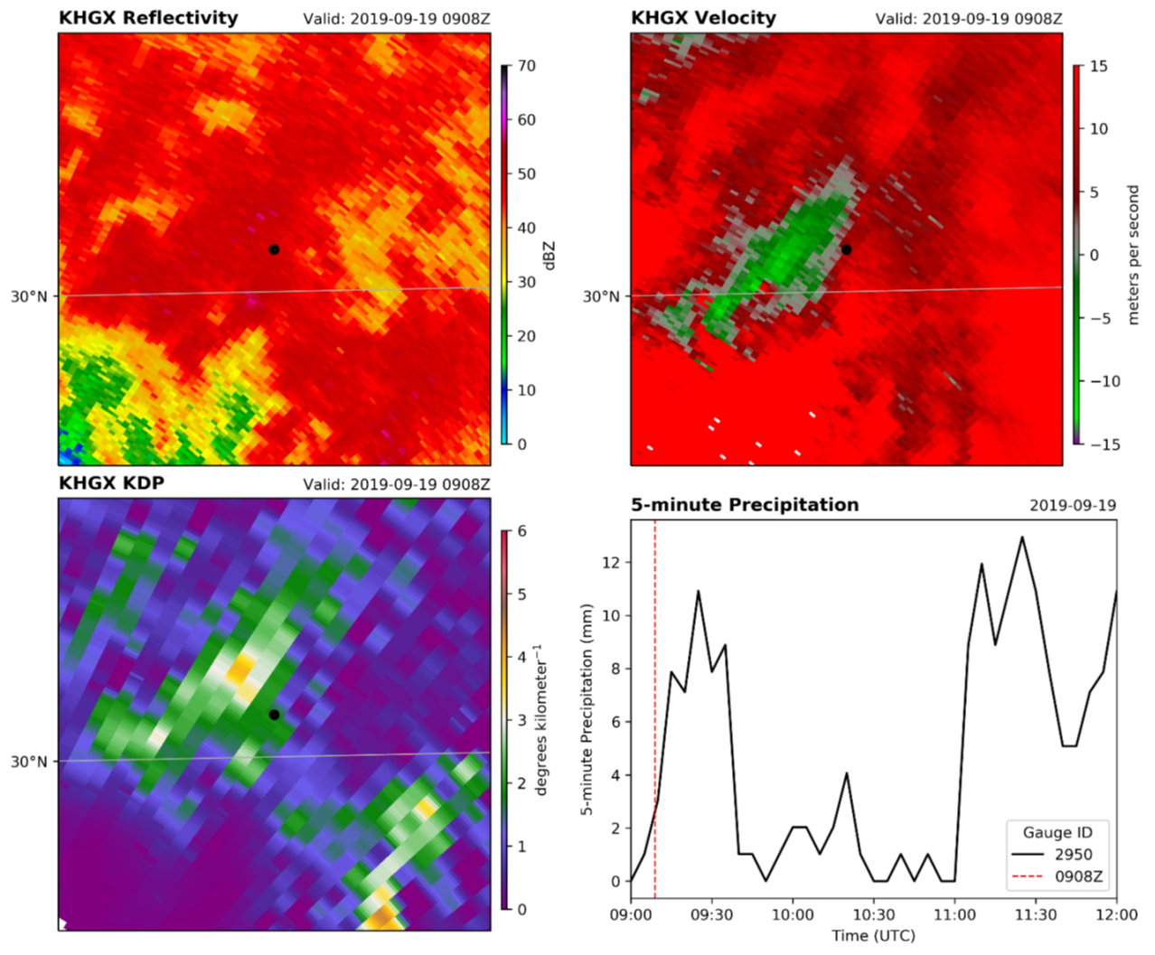
This project involves integrating physical and social science research to examine instances of multiple hazards in the same place and at the same time: namely tornadoes and flash floods (TORFF) during landfalling tropical cyclones. In this reporting period, the physical science research has focused on Tropical Storm Imelda in September 2019, which caused historic flooding along with tornadoes along the Gulf Coast of Texas and Louisiana. We are examining radar observations and numerical model simulations to investigate whether rainfall rates are enhanced in parts of the storm with strong low-level rotation, which are also conducive to tornadoes (Fig. 1).
The social science research has examined data from Twitter, as well as in-depth interviews with National Weather Service offices affected by landfalling tropical cyclones. The Twitter analysis has revealed the multiple hazards associated with tropical cyclones to leave people in “liminality,” or the state of “betwixt and between,” which explains the heightened state of risk people in TORFF situations feel. The NWS interviews have revealed the many challenges faced by operational forecasters in multi-hazards situations, when aiming to both accurately forecast the weather hazards and communicate the many-faceted risks faced by their communities.
Formal publications and reports:
- (None; 28 informal publications and presentations)
Project commenced Sept 2018
This page updated 2020_12_14
Understanding the influence of microphysical processes on the environment and behavior of southeastern-U.S. potentially tornadic storms
D. Dawson, R. Tanamachi (Purdue Univ.)
Approach and Questions:
- Primary objective: Quantify impacts on surface conditions of microphysical changes aloft, using lightning as the linking phenomenon.
- Working hypothesis: Lightning can be used as a predictive indicator of cold pool strength, and thereby serve as an additional, secondary indicator of tornadogenesis potential.
- Methodology: Generate new conceptual models of electrical-microphysical-thermodynamic linkages through intensive, EnKF-based numerical analysis of VORTEX-SE observations for four select cases. Triple-moment microphysical schemes, a state-of-the-art polarimetric emulator, and electrification parameterization schemes will be used.
- R2O: Findings will be disseminated to operational communities via updates to existing NWS and NESDIS training modules.
Recent executive summary:
We are running computer simulations of severe thunderstorm and tornado outbreaks in the southeast-U.S. in an attempt to better understand their behavior. We are interested in how the formation of rain, snow, and hail in the storms affects their potential to produce severe weather, including tornadoes. One aspect we are particularly focused on is the effect of the concentration of aerosols in the storm environment on these processes. (These aerosols serve as nuclei for cloud droplet formation in updrafts and their concentration affects the sizes and numbers of these initial cloud droplets and the ensuing pathways towards precipitation formation). We are running experiments for a few different cases of tornadic storms that occurred during the 2016 and 2017 VORTEX-SE field campaigns in which we vary the initial aerosol concentration. The output of these simulations is being compared with real observations collected during these events. Preliminary results suggest that the simulations are capable of reproducing the storm structure and evolution as well as the form of the rain drop size distributions. Our ultimate goal is to use the knowledge we gain to improve forecasts of severe thunderstorms and tornadoes in this part of the country.
Formal publications and reports:
- Formal publications and reports (None)
Project in progress July 2019
updated 2020-12-14
Integrated Airborne and Ground-Based Analyses of Southeastern Tornadic Storms
M. Biggerstaff (Univ. Oklahoma)
Progress, Plans, Tentative Outcomes:
- Identified two cases to analyze: 3-4 April 2018 and 13-14 April 2018
- Dual-Doppler wind retrievals are underway.
- Surface roughness characterization via land use/land cover data underway.
- Planning to integrate airborne Doppler data into wind retrieval.
Recent executive summary:
(None available)
Formal publications and reports:
- (None; 1 additional informal publications and presentations)
Project in progress July 2019
updated 2019-07-19
Collaborative Research: Human Behavior Before, During, and After Severe Weather Events: In Situ Observations in the U.S. Southeast
J. Friedman, D. LaDue (Univ. Oklahoma); L. Myers (Univ. Alabama)
Hypotheses and Objectives:
- Hypothesis: “An informed social network will result in a relative improvement toward situational best practices for preparedness, sheltering, etc. compared to individuals not exposed to a comparable network. We hypothesize that social networks are an effective means to not only communicate situational best practices, but, also, to ensure the actual implementation and actualization of those best practices during severe weather events.”
- Hypothesis: “When a person is taking protective or preparatory actions during severe weather events that are focused on protecting other people in their social network, their behavior will show patterns of activity that are different from people who think that they are only taking action for themselves.”
- Hypothesis: “There will be a relevant difference between reported and observed behavior during severe weather events. We hypothesize that there is not a single factor that explains these differences, but, rather, multiple identifiable factors.”
- Objective: “Social profiles based on real world, observed behavior of households during severe weather events.”
- Objective: “An overview of best practices and lessons learned in sheltering options, awareness, and actions taken classified by varied home, workplace, and environmental characteristics and vulnerabilities.”
- Objective: “A set of strategies for outreach to these home, workplaces, and environmental types by operational warning communications personnel (forecasters and emergency managers) for better warning dissemination and public response.”
- Objective: “Training content for skill improvement in operational decision making for forecasters and emergency managers using awareness of home, workplace, and environmental
- vulnerabilities.”
Recent executive summary: (Read L. Myers’ summary…)
Formal publications and reports:
- (None; 28 informal publications and presentations)
Project commenced Sept 2018
This page updated 2020_07_10
Improving Forecaster and Partner Interpretation of Uncertainty and Confidence in Risk Information: Cool and Warm Season Tornado Threats in the Southeastern U.S
J. Henderson, J. Spinney (Univ. Colorado/CIRES); J. Demuth (NCAR)
Goals and Approach:
- Goal: “…helping improve understanding of forecasters’ and their partners’ interpretations and uses of different types of information, especially probabilistic information, in warning decisions, and to understand the warning process and information gaps that contribute to uncertainty, this project will examine at different spatial and organizational scales the valences and meanings of the concepts uncertainty and confidence that arise among multiple expert groups in the southeastern U.S. during both cool and warm tornado seasons.”
- Goal: “…develop new knowledge (a) about how meteorologists at national centers, WFOs, and their core partners conceptualize uncertainty and confidence; and (b) how these concepts emerge through various interactions and influence risk communication among these groups leading up to and during tornado events.
- “Two complementary methods will be used to understand the different valences of uncertainty and confidence: (1) naturalistic observations with staff in three sites simultaneously: the SPC, a WFO, and a proximate emergency operation center before and during warning operations; and (2) in-person interviews with these same groups.”
Formal publications and reports (None)
Project in progress July 2019
updated 2019-07-19
Using Machine Learning to Improve Warnings of Nonclassical Tornadic Storms
P. Markowski, G. Young (Penn State Univ.)
Goals and Approach:
- Goal: “…improving warnings for these nonclassical tornadic storms.”
- Developed a set of 128 simulations of non-classical potentially tornadic storms with CM1 that may contain intense vortices representing increased tornado potential.
- Currently applying the ML techniques to numerically simulated nonclassical tornadic storms, as opposed to actual nonclassical storms [as] a necessary first step, prior to applying any techniques to real cases observed with WSR-88D.
- Assessing skill in predicting the development of intense vortices.
Recent executive summary:
A team of Penn State researchers (Dylan Steinkruger, George Young, and Paul Markowski) is using machine-learning techniques to improve the tornado warnings in severe thunderstorms that lack the classic radar signatures routinely relied upon by forecasters for warning issuance. Such “nonclassical” severe storms are both dangerous to the public and particularly challenging for forecasters. The results thus far are extremely encouraging. The team’s automated algorithm has shown an ability to predict where tornadoes potentially could develop, up to 20 minutes in advance, within computer generated nonclassical storms. Later work will examine actual nonclassical storms and will have to demonstrate similar skill while relying on radar observations.
Formal publications and reports (1 formal in review at Wea. Forecasting; 2 informal publications)
Project in progress September 2020
updated 2020-11-11
VORTEX-SE: Establishing the Interdependence of Thermodynamic State, Lightning, and Low-Level Vorticity as a Foundation for Improved Forecaster Awareness of Southeast U.S. Storms
C. Weiss, E. Bruning (Texas Tech Univ.); C. Schultz (NASA/MSFC); D. Dowell, C. Alexander (NOAA/ESRL)
Plans, Progress and Tentative Outcomes:
- Augmenting sticknet data sets with Meso18-19 cases; analysis of cold pool characteristics underway.
- Analysis underway of 4D evolution of lightning (sticknet, GLM, LMA) and relationship to low-level vorticity
- Will assimilate flash information into HRRRE
- Will test new findings at NWSFO Huntsville
Recent Executive Summary:
This project is assessing the value of surface observations of temperature, humidity, wind and air pressure in discriminating tornadic and nontornadic thunderstorms across the southeastern United States. We have found that sharp changes in air density (temperature, primarily) are associated with increased tornado potential over an assessment of multiple cases.
Lightning data from both a satellite imager and a surface network are integrated into these analyses to understand how the distribution and evolution of lightning trends associate with tornado likelihood. Lightning observations are also being directly assimilated into high-resolution numerical models to assess their utility in improving forecasts of storms. Both lightning and surface data are being supplied to local National Weather Service offices in real time as a means to improve situational awareness in the warning decision environment.
Formal publications and reports (None; 7 informal publications and presentations)
Project in progress November 2020
updated 2020_11_11
Characterization of storm structure and storm environments through the integration, improvement and analysis of multi-platform radar data
J. Wurman, J. Marquis, K. Kosiba (Center for Severe Weather Research)
Plans, Progress and Tentative Outcomes:
- Assembling research data sets from earlier VORTEX-SE field campaigns plus the spring 2018 field campaign.
- Assess the utility of using mobile Doppler radar VAD analyses for environmental wind profiling.
- Explore integration of airborne and ground-based Doppler data in wind syntheses.
Recent Executive Summary:
Three-dimensional winds derived from dual-Doppler analyses have been used to assess mechanisms for low-level vortex formation along the leading edge of QLCSs. Currently, we focused on the role of horizontal shearing instability (HSI) and its role in vortexgenesis. Analyses suggest that HSI is ubiquitous across QLCS leading edges when vertical vorticity is present, but in the analyzed cases, these vortices rarely produced tornadoes. This suggests that HSI may lead to vertical vorticity generation, but that the vertical vorticity generated via HSI is insufficient for tornadogenesis. Therefore, as a predictor of tornadogenesis, the existence of HSI, alone, is a poor discriminator for tornadogenesis. It is possible that the magnitude of the instability may be a better discriminator, but current analyses show varying magnitudes of instabilities produce vertical vorticity of similar strength.
Formal publications and reports (None)
Project in progress July 2019
updated 2020-12-14
VORTEX-SE: Evaluating the Impact of Additional Atmospheric State Data in HRRRx and RTMA-3D
D. Turner, M. Marquis, C. Alexander (NOAA/ESRL)
Plans, Progress and Tentative Outcomes:
- Assimilate Meso18-19 special soundings, profilers, and sticknet in various combinations in the ESRL experimental HRRRx in data-denial observing system experiments to assess the forecast value of these systems.
Formal publications and reports (None)
Project in progress July 2019
updated 2019-07-23
Advancing meteorological and operational detection of mesoscale kinematic and thermodynamic variability: An improved understanding of its sources within the boundary layer during tornado and severe weather events in the Southeast
K. Knupp (Univ. Alabama Huntsville)
Plans, Progress and Tentative Outcomes:
- Goal: Develop and test high-resolution VAD for scanning radars for low-leve wind profiling; prototype on ARMOR.
- Goal: Develop mesoscale VAD to assess mesoscale variability at larger range than profiling VAD.
- Goal: Assess quality and utility of Citizen Weather Stations for mesoscale analysis in the Southeast
Formal publications and reports (None; NNN informal publications and presentations)
Project in progress July 2019