When Radar Observed Precipitation Does Not Reach the Ground

While gauges provide a surface observation about how much precipitation has fallen, they are point observation that do not represent the spatial distribution of precipitation. This is why forecasters and scientists have relied on radar coverage to estimate precipitation across a large area; however, what is detected by radar at beam level does not equate to what is observed at the surface.

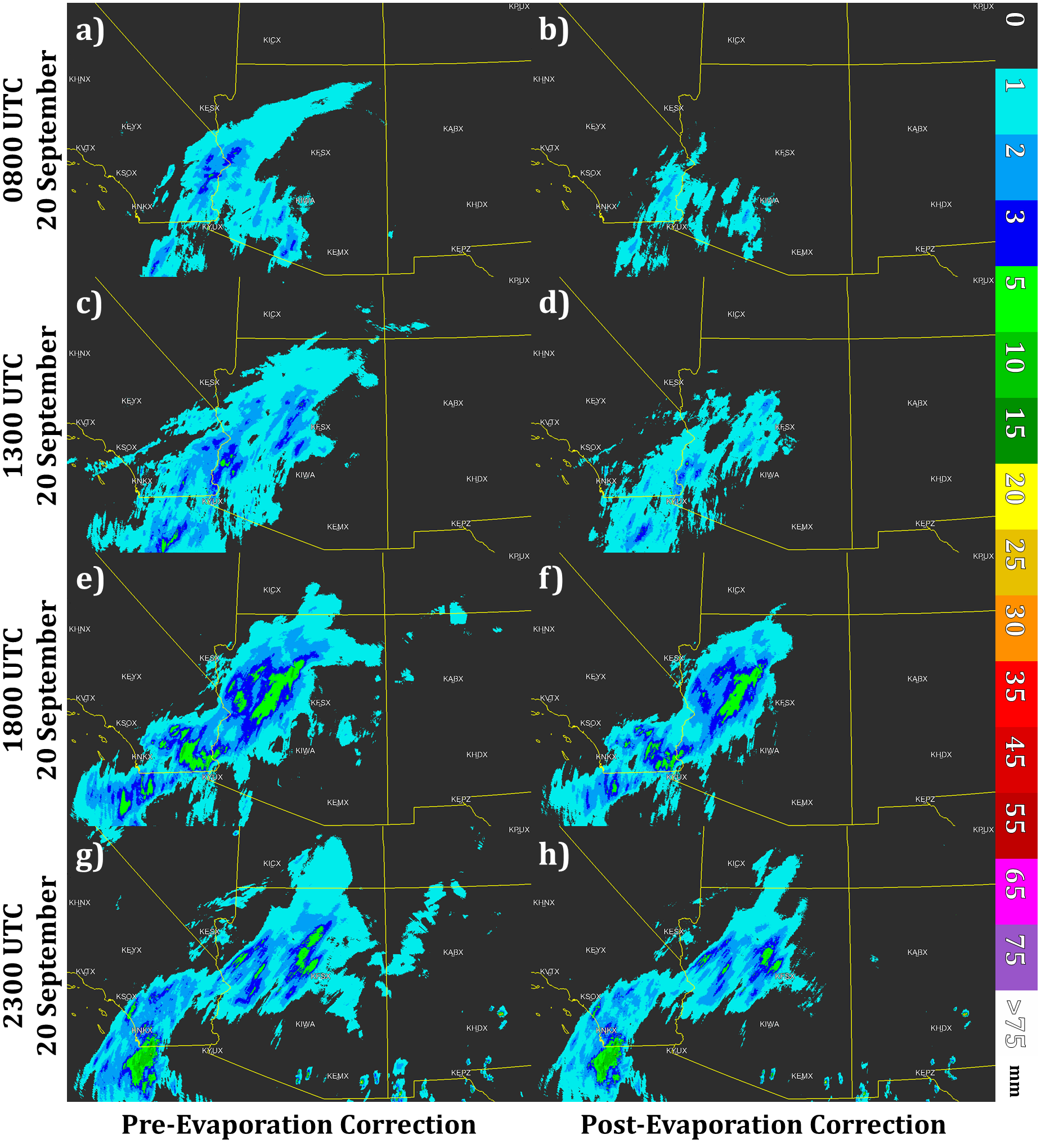
One of the primary contributors to changes in precipitation estimations between the radar beam level aloft and the surface is evaporation. Evaporation can greatly reduce or even completely remove light precipitation before it reaches the ground. Using radar-based observations without accounting for evaporation has shown a systematic overestimation bias of precipitation in semi-arid environments and the production of “false light precipitation” (areas where the radar detects light precipitation but gauges record nothing).

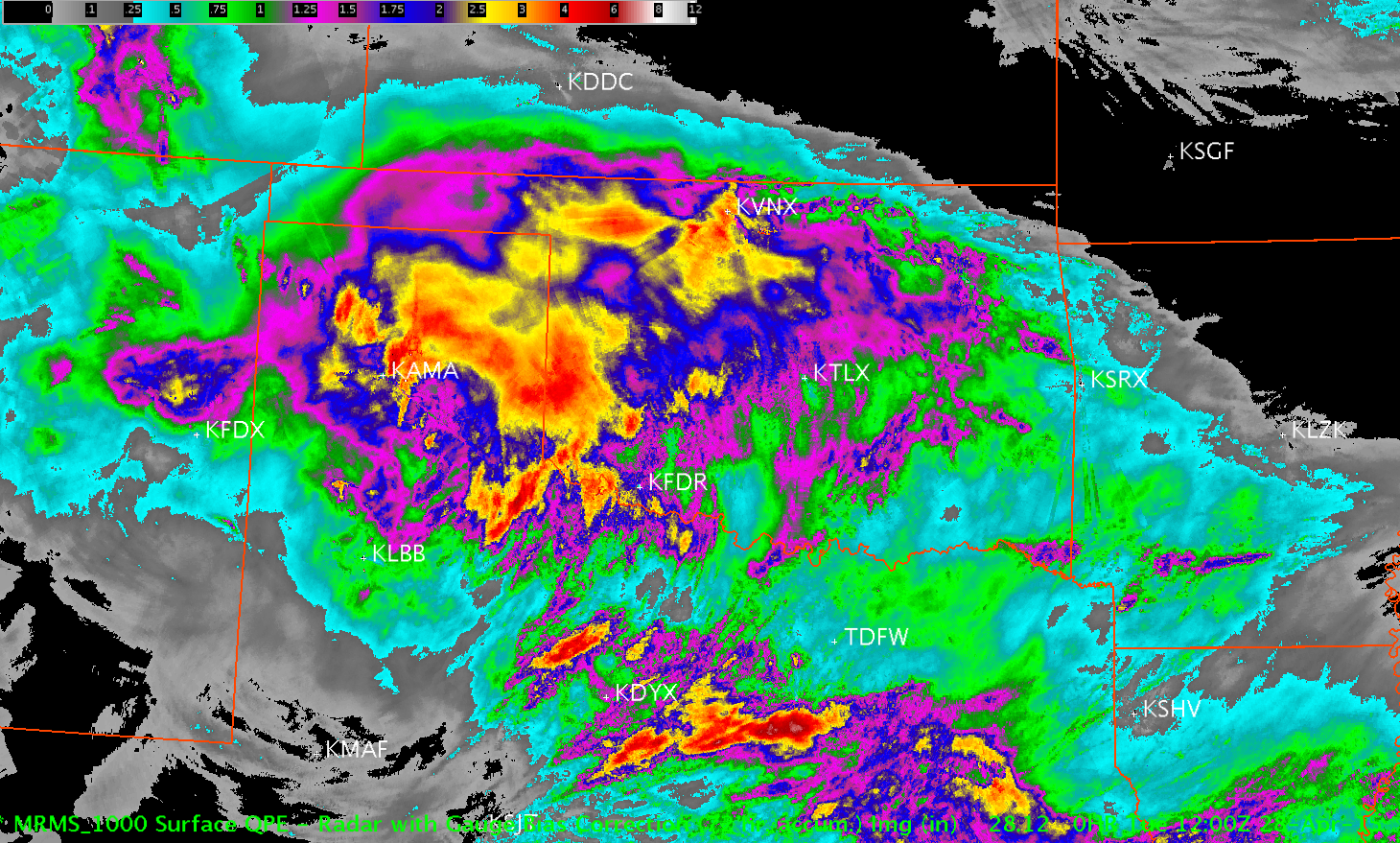
In the upcoming MRMS v12.0 update, evaporation will be accounted for in the generation of radar-based QPE. Using three-dimensional model atmospheric parameters, radar precipitation estimates are modified based on the model environment it falls through at each grid cell. This has shown to improve precipitation coverage and accuracy as well as improve gauge quality control. More information can be found in the recently published article by Martinaitis et al. (2018).

Comparison of radar-derived QPE before and after an evaporation correction scheme. From Martinaitis et al. (2018).
Tags: None

Continuous Testing and Evaluation

Every product that is operationally implemented within MRMS undergoes extensive testing and evaluation. This testing is conducted through numerous case study analysis and real-time analysis on the MRMS QPE Verification System (QVS). This system allows MRMS researchers to compare multiple experimental and operational QPE datasets against each other and against various gauge observations. Case studies provides MRMS researches a way to go more in depth into different events or products to determine how they are performing and what could be done to further enhance QPE accuracy. Publications like the recent one by Cocks et al. (2017) show how these evaluations influence the design and evolution of MRMS QPE.

Evaluation of various single radar and MRMS QPEs from Cocks et al. (2017).

While MRMS v11.5 is going through its final tests at NCEP for operational use, the updates of MRMS v12.0 are being evaluated now for future release. The constant testing of our latest products allows us to continually refine our schemes and promote more accurate QPEs for the field. MRMS v12.0 is by far the biggest update to how we generate precipitation estimations since the initial operating capabilities four years ago. More on what is going into MRMS v12.0 will be discussed soon…

Tags: None

MRMS QPE Featured in Hurricane Harvey Report

The National Hurricane Center (NHC) completes a tropical cyclone report for each classified storm in the Atlantic and Eastern Pacific basins. In January 2018, the NHC release their report for Hurricane Harvey, “the most significant tropical cyclone rainfall event in United States history.” Hurricane Harvey not only set the rainfall total from a tropical cyclone (60.58 inches near Nederland, Texas), but had 20 rain gauges recording at least 48 inches (4 feet) of rain and 242 rain gauges recording at least 36 inches (3 feet) of rain during the event.

However, there are challenges with accurately measuring historic rainfall during a tropical cyclone. First, many rain gauges have a cylinder that can handle 11-12 inches of rain before having to be emptied, which could be challenging in tropical cyclone or flash flood conditions. Second, gauges are susceptible to wind undercatch, which could reduce their measured totals. In the Hurricane Harvey report, the NHC featured the MRMS radar-derived quantitative precipitation estimation (QPE) as another means of determining the potential maximum rainfall, which estimated 65-70 inches (see image below). These estimated values were outside of any gauge reports.

While Hurricane Harvey showed the utility of MRMS QPE during this historic event, NSSL scientists are continuing work on improving the QPE during tropical cyclone events, including new techniques for handing efficient tropical precipitation and for gauge wind undercatch.

Tags: None

New MRMS QPE Web Page Information

In 2017, the MRMS data hosted at NSSL was moved on to new internal NSSL servers with new web interfaces. Two separate pages were developed to accommodate access to the MRMS data.

MRMS Operational Product Viewer (Public Access): This site provides all end-users an one-week rolling archive of operational MRMS data.

MRMS Development Product Viewer (Restricted Access): This site provides three versions of archived and real-time MRMS data: 1) The current operational version, 2) the development version being tested at NCO, and 3) experimental versions of data being tested at NSSL. Access to this page requires a request to NSSL and a government-owned IP address, with preferences to site accessibility evaluated on a case-by-case basis. To request access to this page, please contact the following personnel: steven.martinaitis@noaa.gov, stephen.cocks@noaa.gov, and jian.zhang@noaa.gov.

Tags: None

New MRMS Web Page Coming Soon

A significant overhaul is being done to the MRMS web page. Our public MRMS website is in the process of being upgraded and moved to a new web address.  As part of this upgrade, data flow is being gracefully re-directed; therefore, the current public website will not have the most up-to-date MRMS data.  All of these changes will not affect the operational MRMS data which will continue to flow from NCEP to our customers.

More information will come shortly…
Tags: None

MRMS QPE Research at AMS Meetings

Members of the MRMS QPE group have been presenting their research at a number of AMS meetings in 2016, including the annual meeting back in January and, more recently, the Mountain Meteorology Conference, in June. Listed below are relevant research that was presented at these conferences:

Grams, H. M., J. J. Gourley, and P. E. Kirstetter, 2016: Integration of GOES-R into the Multi-Radar Multi-Sensor system for high resolution, seamless QPE in complex terrain. 17th Conf. on Mountain Meteor., Burlington, VT, Amer. Meteor. Soc., 14.3. [Link]

Zhang, J., Y. Qi, C. Langston, and B. T. Kaney, 2016: Local gauge correction of radar QPE in the Multi-Radar Multi-Sensor system. 30th Conf. on Hydrology, New Orleans, LA, Amer. Meteor. Soc., 8.1. [Link]

Tang, L., K. Elmore, J. Zhang, H. Grams, and K. W. Howard, 2016: Three dimensional aviation-specific hydrometeor classification for polarimetric WSR-88D network. Fifth Aviation, Range, and Aerospace Meteorological Special Symposium, New Orleans, LA, Amer. Meteor. Soc., 834. [Link]

Tang, L. J. Zhang, C. Langston, and K. Cooper, 2016: Canadian radar quality control in Multi-Radar Multi-Sensor system. Fifth Aviation, Range, and Aerospace Meteorological Special Symposium, New Orleans, LA, Amer. Meteor. Soc., 835. [Link]

Stumpf, G. J. and Coauthors, 2016: The Multiple-Radar / Multiple-Sensor products: The first year of NWS operations. 32nd Conf. on Environmental Information Processing Technologies, New Orleans, LA, Amer. Meteor. Soc., TJ7.3. [Link]

Qi, Y. and J. Zhang, 2016: Physically based two-dimensional seamless mosaic radar QPE in a national network. 30th Conf. on Hydrology, New Orleans, LA, Amer. Meteor. Soc., 562. [Link]

Martinaitis, S. M., Y. Qi, S. B. Cocks, J. Zhang, and K. Howard, 2016: Advancement of a real-time automated gauge quality control process Multi-Radar Multi-Sensor precipitation estimation. 30th Conf. on Hydrology, New Orleans, LA, Amer. Meteor. Soc., 3.1. [Link]

Martinaitis, S. M., Y. Qi, S. B. Cocks, L. Tang, C. Langston, B. T. Kaney, J. Zhang, and K. Howard, 2016: Development of a merged precipitation product for the automated Multi-Radar Multi-Sensor system. 30th Conf. on Hydrology, New Orleans, LA, Amer. Meteor. Soc., 553. [Link]

Cocks, S. B., S. M. Martinaitis, Y. Qi, H. Grams, K. W. Howard, and J. Zhang, 2016: MRMS QPE performance east of the Rockies during the 2014 warm season. 30th Conf. on Hydrology, New Orleans, LA, Amer. Meteor. Soc., 564. [Link]

Cocks, S. B., S. M. Martinaitis, K. W. Howard, and J. Zhang, 2016: MRMS QPE performance west of the Rockies during the 2013-2014 cool and warm seasons. 30th Conf. on Hydrology, New Orleans, LA, Amer. Meteor. Soc., 565. [Link]

Tags: None

MRMS QPE Research Presented at 2015 NWA Annual Meeting

Research scientists working with and evaluating the Multi-Radar Multi-Sensor (MRMS) quantitative precipitation estimation (QPE) products presented their work at the 2015 National Weather Association (NWA) Annual Meeting held in Oklahoma City, OK on 19-22 October 2015. Below is a list of topics that were presented at the meeting:

Zhang, J., Y. Qi, S. Stevens, B. Kaney, C. Langston, K. Ortega, B. Nelson, K. Howard, and O. Prat, 2015: Multiple Year Reanalysis of Remotely Sensed Storms – Precipitation (MYRORSS-P). 40th Natl. Wea. Assoc. Annual Meeting, Oklahoma City, OK, BP-96. [Link]

Cocks, S. B., S. M. Martinaitis, K. Howard, and J. Zhang, 2015: MRMS QPE performance during the 2014 warm season. 40th Natl. Wea. Assoc. Annual Meeting, Oklahoma City, OK, CP-5. [Link]

Cocks, S. B., S. M. Martinaitis, K. Howard, and J. Zhang, 2015: Conducting site visits to facilitate the operations to research process with MRMS QPE. 40th Natl. Wea. Assoc. Annual Meeting, Oklahoma City, OK, CP-6. [Link]

Qi, Y., S. Martinaitis, S. Cocks, and J. Zhang, 2015: A real-time automated quality control of hourly rain gauge data based on multiple sensors in MRMS system. 40th Natl. Wea. Assoc. Annual Meeting, Oklahoma City, OK, CP-43. [Link]

Grams, H. M., J. J., Gourley, and P. Kirstetter, 2015: Integrating high resolution ground radar and satellite observations for rapidly updating precipitation estimates in data sparse regions. 40th Natl. Wea. Assoc. Annual Meeting, Oklahoma City, OK. [Link]

Tags: None

One Year of MRMS in Operations

The Multi-Radar Multi-Sensor (MRMS) has been operational for just over a year and has recently been streaming live to National Weather Service (NWS) offices. Within the current operational MRMS suite are a number of products related to precipitation estimation. They include:

  • Seamless Hybrid Scan Reflectivity (SHSR)
  • Radar Quality Index (RQI)
  • Surface Precipitation Type (SPT)
  • Surface Precipitation Rate (SPR)
  • QPE – Radar-Only
  • QPE – Gauge-Only
  • QPE – Radar with Gauge Bias Correction
  • QPE – Mountain Mapper

Click here to read more about the operational implementation of MRMS from NSSL.

72-hour Radar with Gauge Bias Correction QPE on 28 April 2015
Tags: None