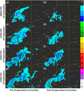
While gauges provide a surface observation about how much precipitation has fallen, they are point observation that do not represent the spatial distribution of precipitation. This is why forecasters and scientists have relied on radar coverage to estimate precipitation across a large area; however, what is detected by radar at beam level does not equate to what is observed at the surface.
One of the primary contributors to changes in precipitation estimations between the radar beam level aloft and the surface is evaporation. Evaporation can greatly reduce or even completely remove light precipitation before it reaches the ground. Using radar-based observations without accounting for evaporation has shown a systematic overestimation bias of precipitation in semi-arid environments and the production of “false light precipitation” (areas where the radar detects light precipitation but gauges record nothing).
In the upcoming MRMS v12.0 update, evaporation will be accounted for in the generation of radar-based QPE. Using three-dimensional model atmospheric parameters, radar precipitation estimates are modified based on the model environment it falls through at each grid cell. This has shown to improve precipitation coverage and accuracy as well as improve gauge quality control. More information can be found in the recently published article by Martinaitis et al. (2018).

