6/13/17 – SW Kansas/NW Oklahoma/NE Texas Panhandle

Mobile mesonet vehicle
The long-term goal of research acquired during RiVorS is to help develop reliable probabilistic guidance products, enhance capabilities for WSR-88D and provide and communicate warning uncertainty information for high-impact weather events. (Photo by Matthew Mahalik/ OU CIMMS)

This was the last potential day of operations for RiVorS. Still straightening out some damaged parts from yesterday’s deployments, we had originally expected to head home, forgoing a promising set-up in northern Nebraska and southern South Dakota. However, with extreme low and mid-level instability in place and winds turned just enough out of the east, one last late-season dryline event looked possible across Kansas and the Oklahoma/Texas Panhandles. The NSSL and Texas Tech University teams decided to head south along the dryline on the way back from Nebraska to the Southern Plains.

One interesting thing about driving along the dryline in mobile mesonets is the ability to watch temperature and humidity measurements fluctuate along the boundary. In front of the dryline it was downright muggy, with dewpoints in the low 70s. Behind, it was HOT with temperatures reaching 100 degrees.

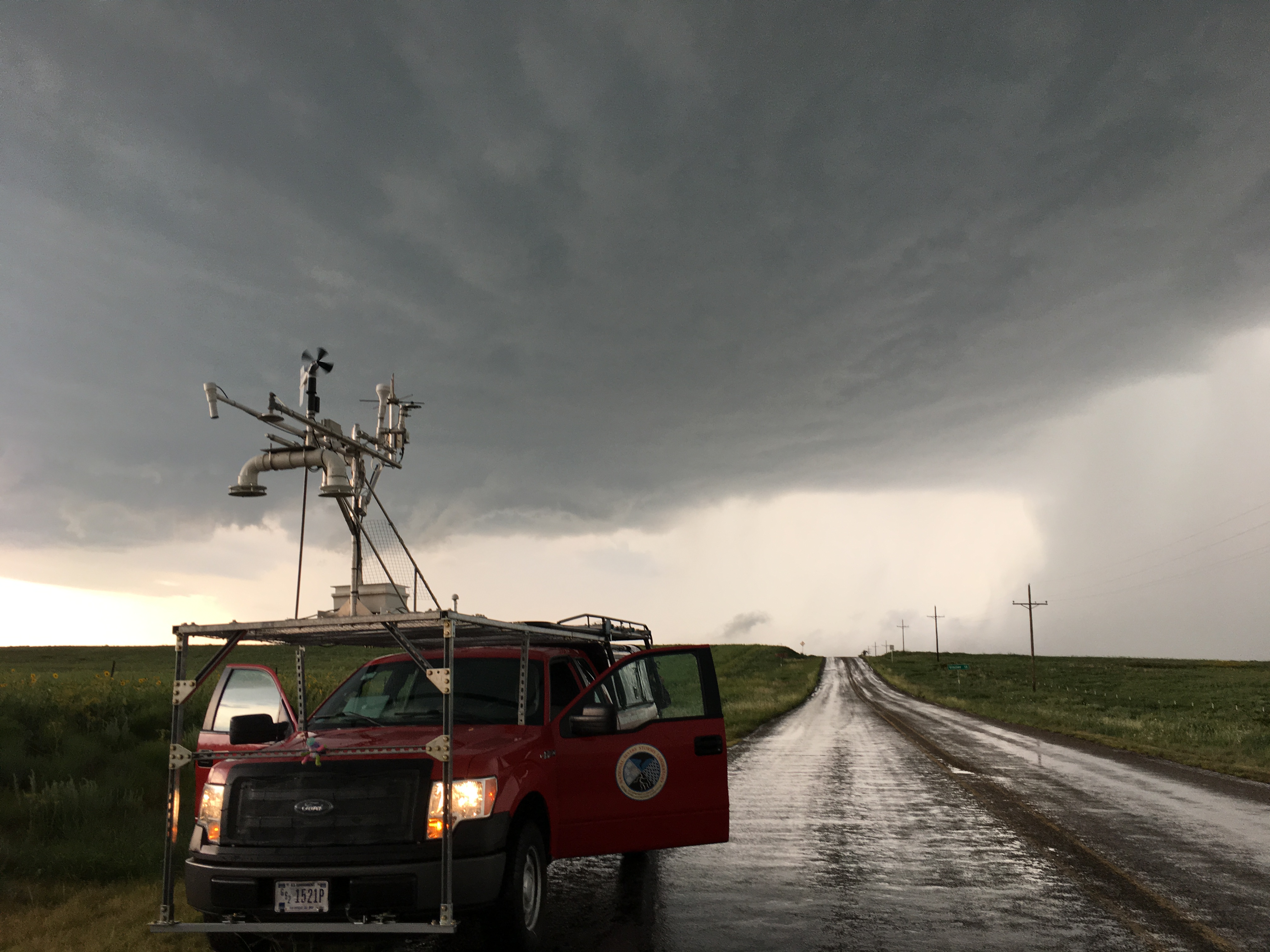
Once we got close to Dodge City, Kansas, in the late afternoon, the cap was removed and convective initiation kicked off with storms firing from Kansas to Texas. As with most dryline setups, we first needed to find the storm that had the best chance to become supercellular. Observations pinpointed the Texas Panhandle as having the most favorable conditions, so we raced south toward a growing storm north of Amarillo.

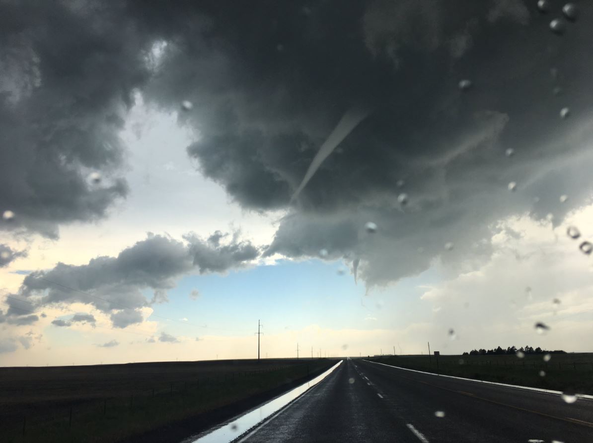
After a late start, we had to play catch-up, meaning we did not reach the storm until almost two hours after initiation. We first transected it at the town of Canadian, Texas, where we encountered curiously small raindrops…but not much else. The storm was still struggling with strong, cold outflow and was unable to organize until east of town.

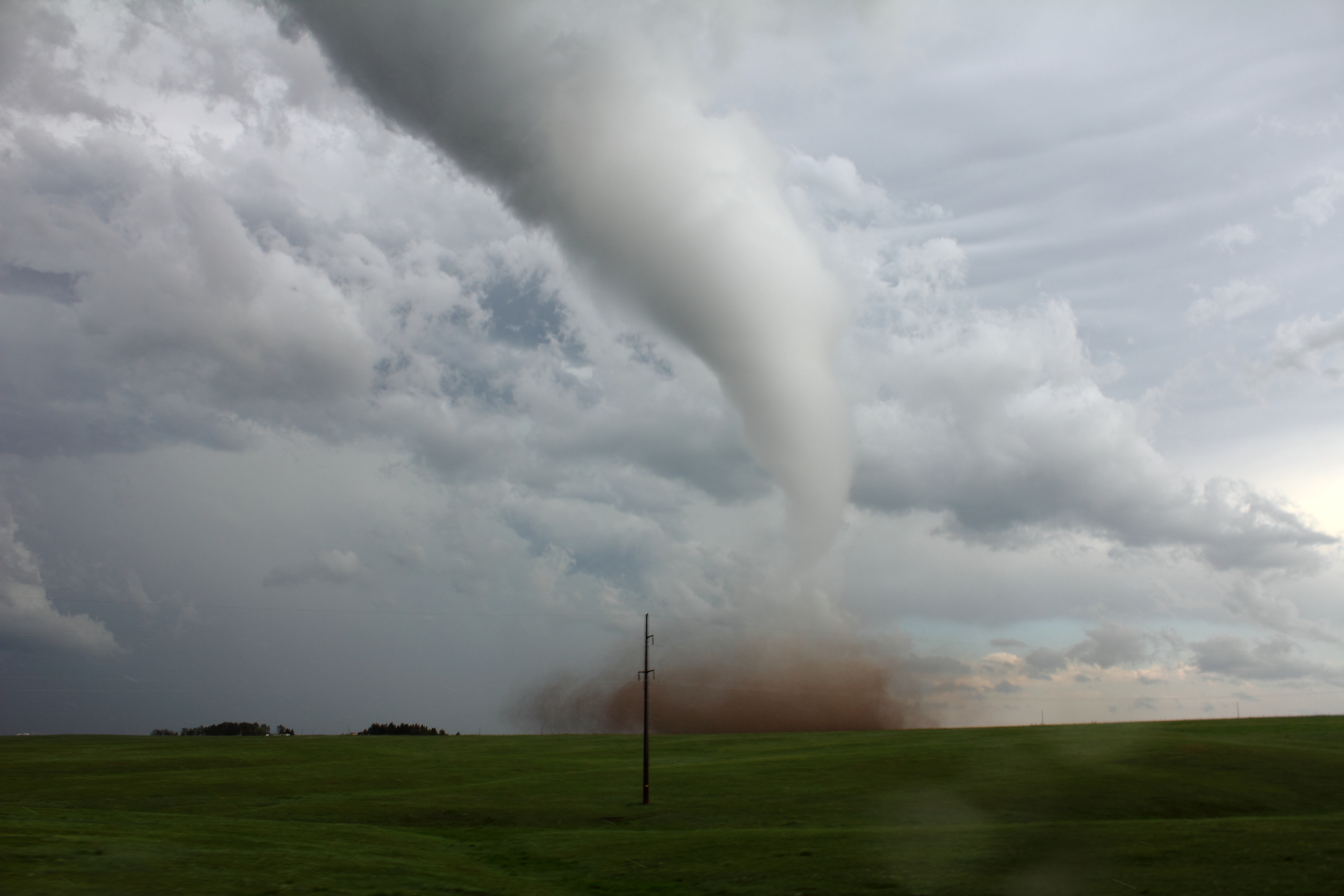
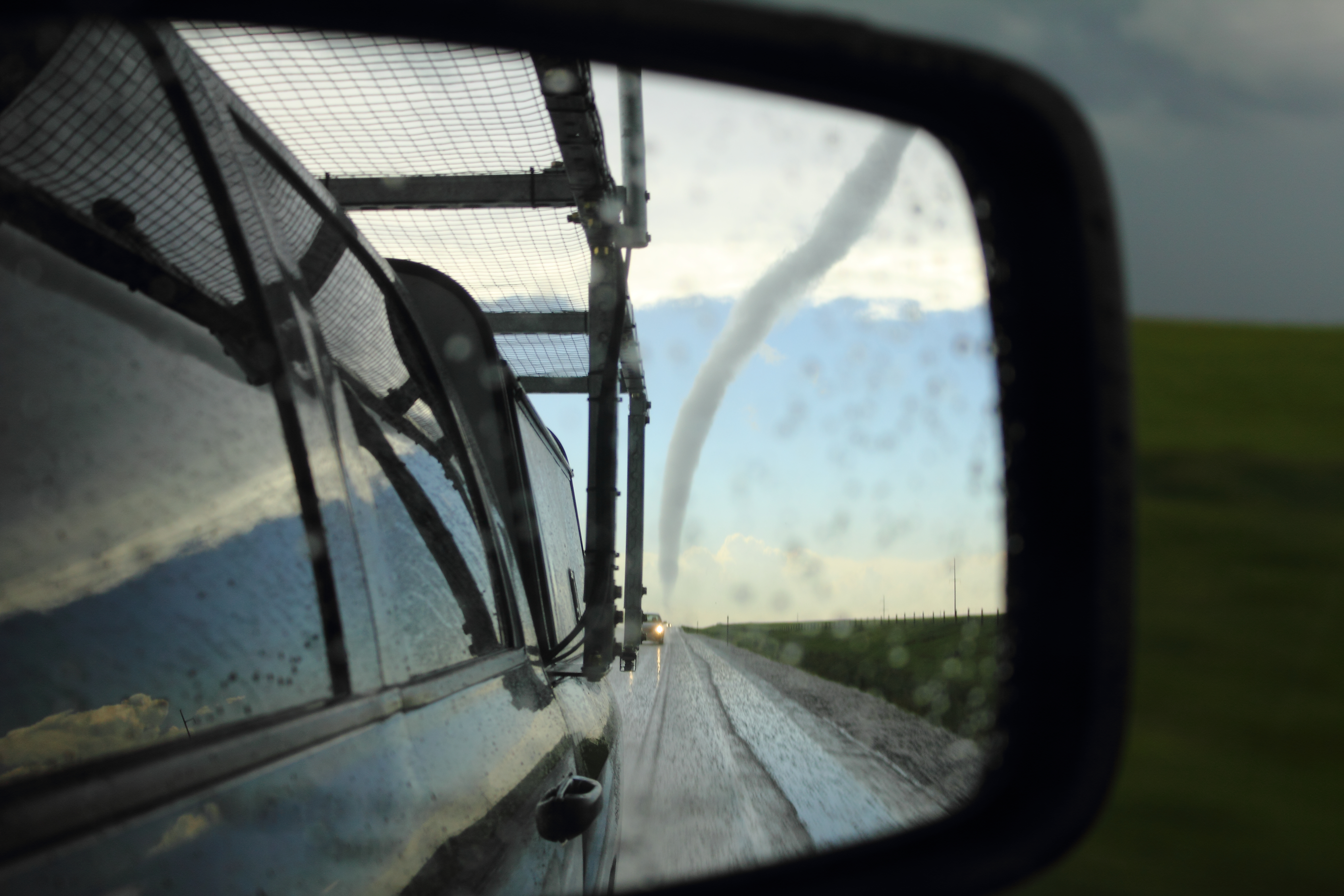
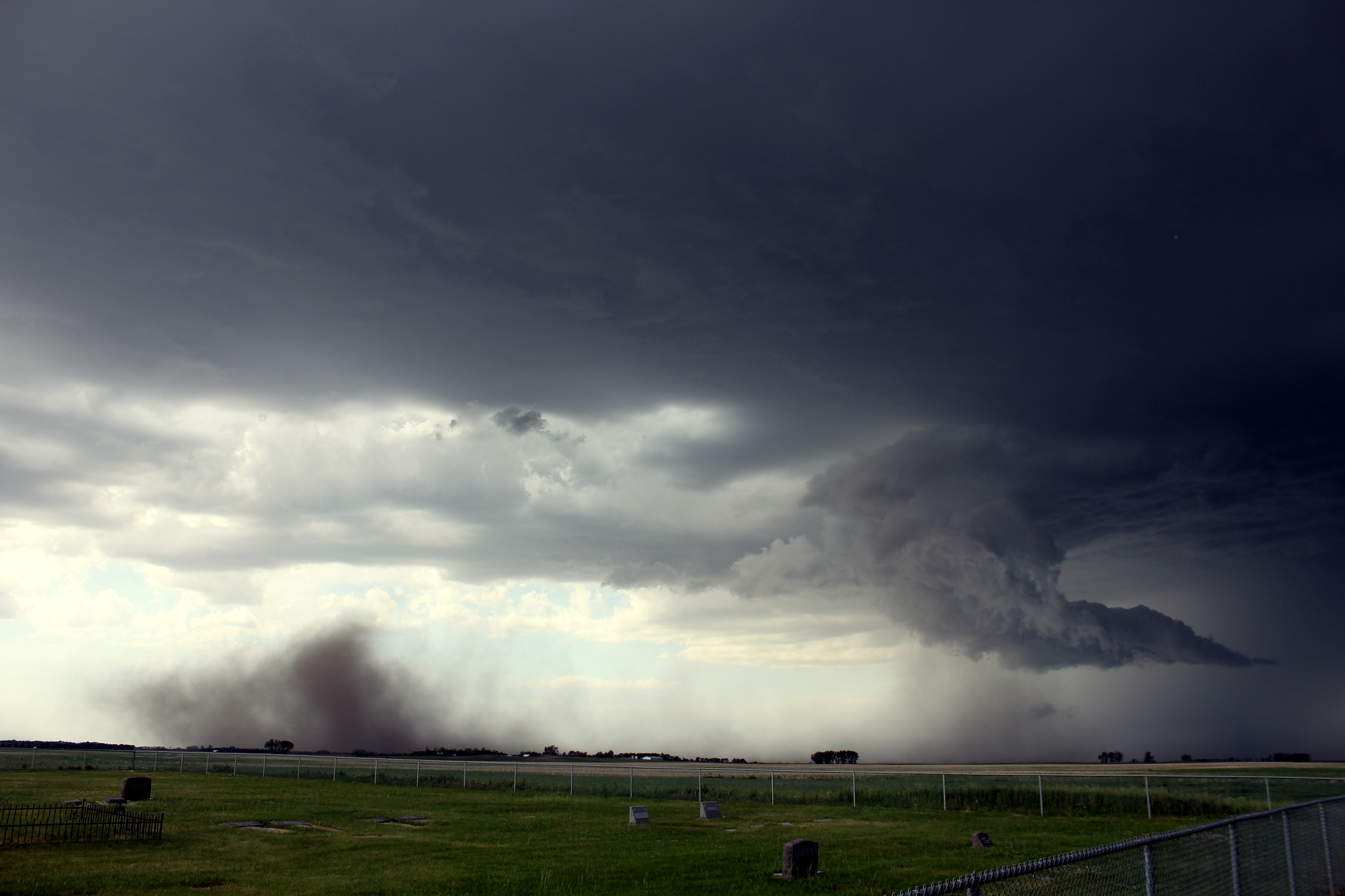
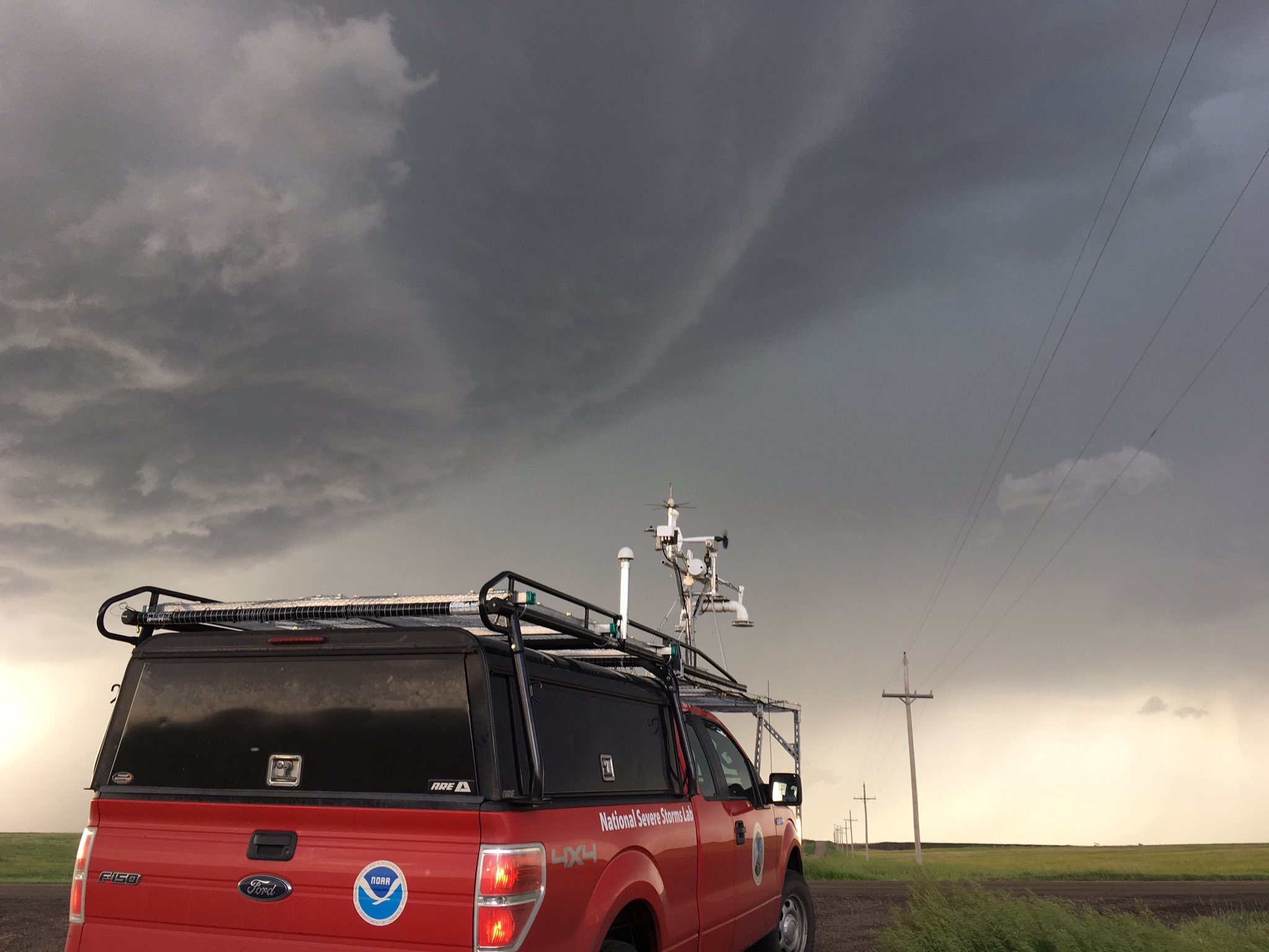
At first, we were wondering why we had not encountered any hail at all, but less than 30 minutes later large hail began to fall. Around this time, we sampled a few small wind-shift features that resembled vorticity rivers and soon after the updraft base began visibly rotating. The largest confluence region south of the forward flank appeared to feed directly into the rotating updraft and moist outflow surges were visibly being lifted and condensing as they were ingested. We observed a strongly rotating wall cloud and funnel at this time.

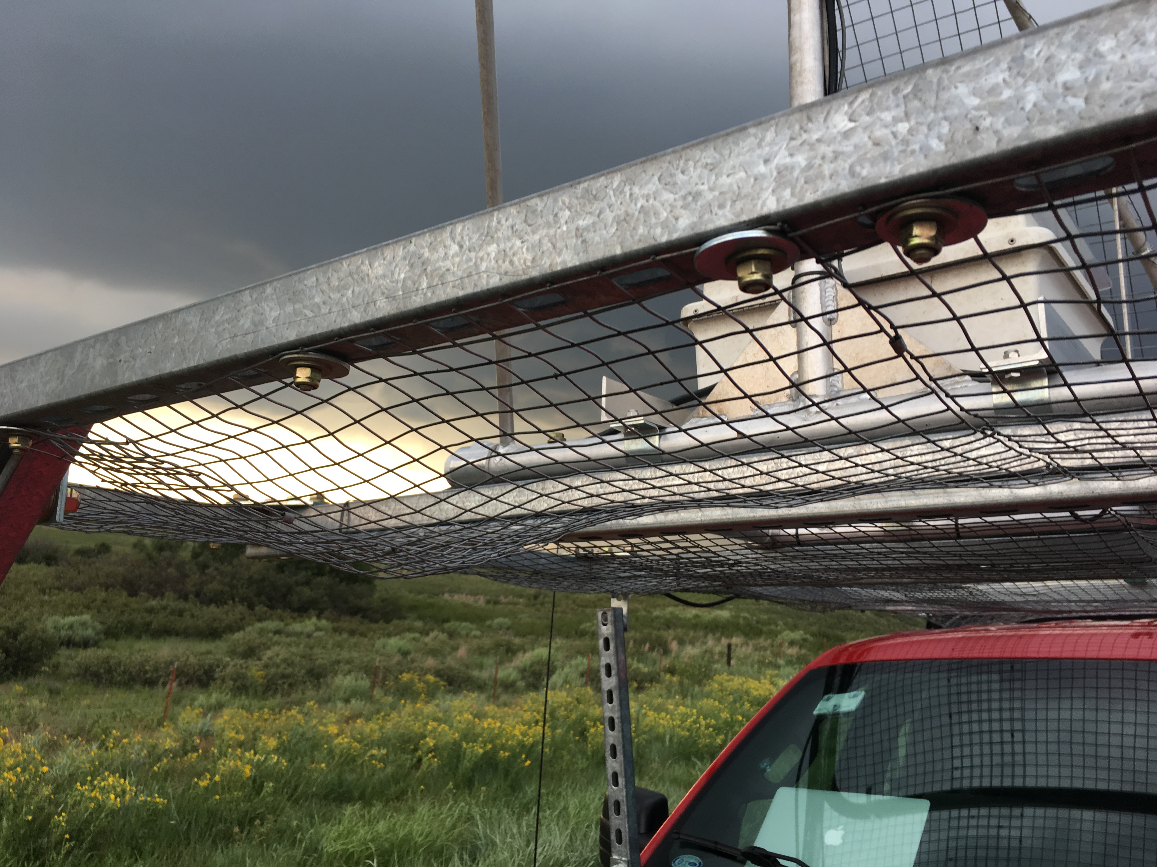
Hail larger than baseballs battered us for five to six minutes, damaging our anemometer and driver side mirror. These were not only the largest hailstones we saw during RiVorS, but they were also among the densest. Hailstone density, or hardness, can be just as important as size when it comes to potential damage.

Hail damage on mobile mesonet
Damage to the mobile mesonet’s hail cage after the storm. (Photo by Matthew Mahalik/ OU CIMMS)

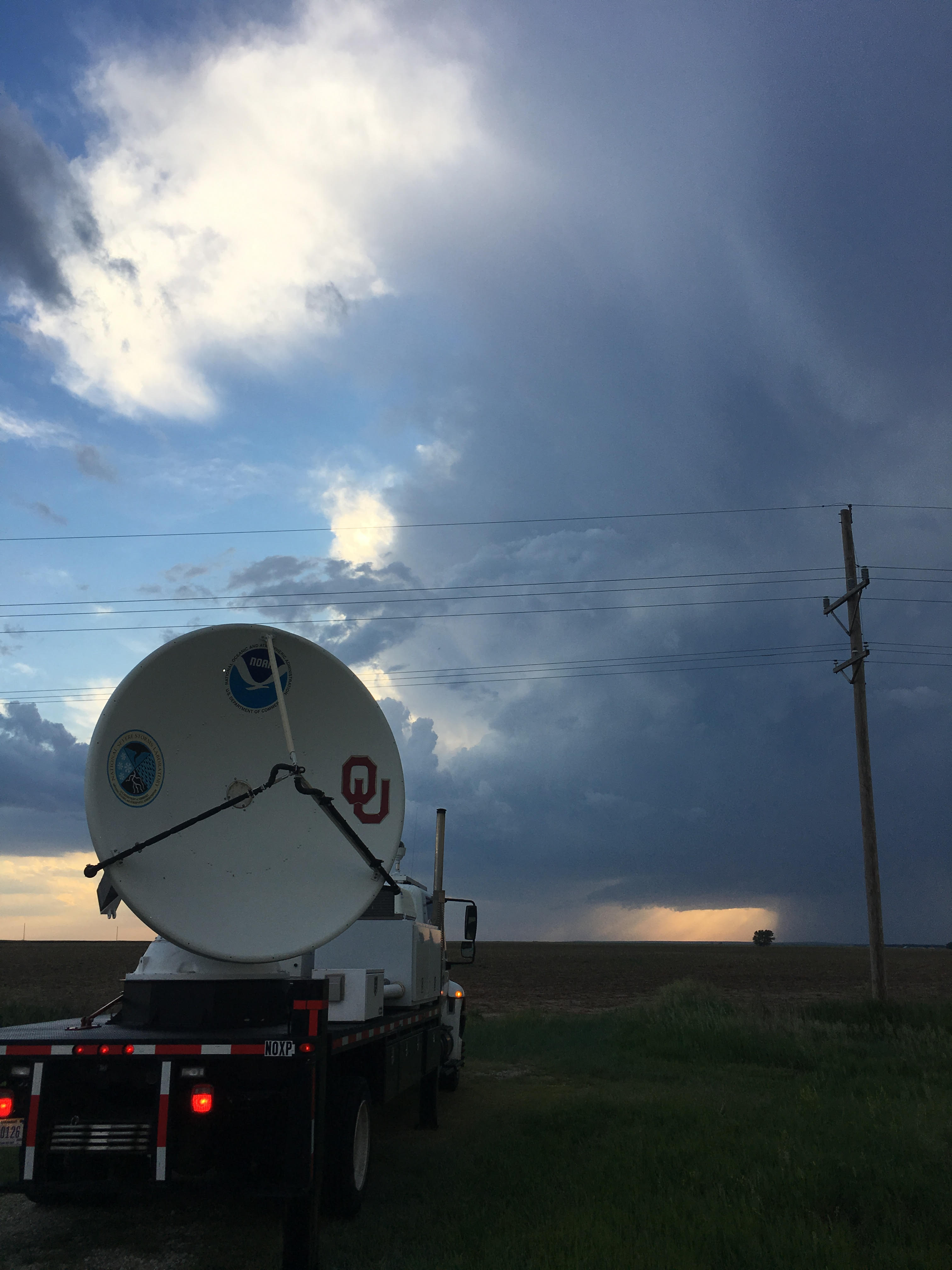
Our deployment was over. We pulled in front of the storm and watched the precipitation core slowly shrink. It was finally time to head back home to Norman, Oklahoma, for the first time in a week. Considering we had expected to head straight home and maybe catch a weak storm as it came off the dryline, collecting data from another pre-tornadic supercell was a success.

Now time to clean the trucks and examine the data!

Tags: None

6/12/17 – Eastern Wyoming/Western Nebraska

Models were becoming increasingly confident in the potential for one of the biggest severe weather events on record in Wyoming, so we were prepared for a long day of data collection. Teams got off to an early start after a discussion with forecasters from the National Weather Service Forecast Office in Cheyenne, and our early morning balloon launch showed conditions were indeed in place for several supercells.

The first storm of the day fired right on schedule on the eastern slopes of the Laramies, north of Cheyenne. By the time it reached Interstate 25, it had developed into a supercell and would go on to produce several small tornadoes. However at the same time, a cluster of severe storms to the south had developed near Fort Collins, Colorado. It was a difficult decision: follow the isolated storm in very favorable conditions to the north (away from our initial location), or let several organizing storms come to us, moving into the more favorable environment. We ended up staying south where there were more deployment options.

TTU radar in Wyoming
The TTU Ka-band mobile radar being operated by Abby Kenyon in Wyoming on June 12. This was the first tornado to touch down that day. (Photo by Aaron Hill/TTU)

Our initial target intensified directly over Cheyenne. A large wall cloud formed as we raced ahead of the suddenly strongly rotating supercell. We began transecting the forward flank of the storm as it matured, encountering occasional hail more than two inches in diameter. As we collected data, a tornado stretched and twisted as a second funnel developed, eventually reaching the ground. We moved to gain some distance ahead of these circulations. Then almost as quickly as the storm organized, it completely fell apart, becoming only a ragged band of clouds and rain within minutes.

With the first storm dying, we turned our attention south. The other storms that had formed in Colorado were now a trio of rotating severe storms all in close proximity. Approaching from the northwest, we decided to first sample the western cell and then drift toward the stronger storms further east. This was the weakest of the supercells in the region but its mesocyclone was holding strong, and we performed a few transects near the updraft. From there, we moved toward the stronger, nearby storms.

This repositioning put us in the precipitation for a while, but when we emerged out the other side, we had a pretty amazing view of three distinct mesocyclones. We had worked our way between the original two “twin” mesocyclones moving north from Colorado and a third had split from the easternmost one. We were heading south, with two mesocyclones to our left and one to our right, and all three were producing rotating wall clouds.

At first, the westernmost storm was most active producing a brief multi-vortex tornado. Simultaneously, at the other end of the same wall cloud, a second funnel lowered and briefly touched down as well, before both disappeared. Two minutes later, on the other side of the road, a large funnel dropped and a large cone tornado formed on a hilltop, from the middle mesocyclone.

Amidst sporadic small hailstones, we continued to collect data between the large tornado to the left and yet another tornado to the right. The larger tornado slowly roped out and dissipated as sporadic funnel clouds formed from the three wall clouds. My report to National Weather Service forecasters at this point was simply “occasional tornadoes all around” our location. The most significant tornado we encountered came from the middle mesocyclone after it had crossed into far western Nebraska west of Bushnell.

From here, we were forced to drive southeast, away from the storms, for gas in Kimball, Nebraska. Our parting shot of the two western mesocyclones was another pair of white tornadoes against the dark precipitation core. This was the third and final set of “twin” tornadoes of the day.

By the time we had resumed operations, the massive easternmost mesocyclone had become the dominant one. It was a messy mass of rain and hail with an intense vortex completely rain-wrapped and invisible. The storm provided little chance of safely collecting meaningful data. We followed it for a short time near Scottsbluff, but the huge storm never improved its structure. As the sun set, we declared operations complete for the day and headed east toward our hotel in Ogallala. We unfortunately encountered severe damage in the town of Bayard, which was later determined to have been struck by two separate tornadoes.

This was a long, exhausting day. We made successful deployments on four supercells, three of which produced tornadoes. The final tornado count is unclear, but we encountered more than 10. Finally having data points from tornadic cases to compare against non-tornadic cases is a big step forward for the project.

Tags: None

6/11/17 – Southeast Wyoming

Wyoming, June 11
At least the views were pretty! (Photo by Matthew Mahalik/ OU CIMMS)

Today was the first of two days in Wyoming that had us pretty optimistic about our data collection chances. While whispers from the models for significant severe weather tomorrow began to grow louder, we needed to focus on a challenging “upslope flow” forecast today.

Upslope flow is one of the most common ways to get severe weather in the High Plains. When low-level flow is oriented from the east to west, it is lifted since the terrain slopes upward toward the Rockies. This gradual lift can act almost like a front, lifting surface parcels from the east far enough that they can take advantage of instability and generate storms. This is very common in Colorado and Wyoming and can produce very intense storms, but is often difficult to forecast due to relatively cool and dry air near the surface.

Initial signs pointed to the upslope flow causing active weather off of the eastern slopes of the Laramie Mountains north of Cheyenne, Wyoming. Sometimes though, things change. Overnight, a weak surface low pressure center developed in north central Nebraska, pulling winds in our area around to the northwest (NOT upslope). The result was a loss of several hours of upslope lifting before the wind direction did eventually shift to east. Combined with a slight delay in upper-level energy from a larger system further west, the conditions just never came together as we had expected. This was confirmed by a series of radiosondes we launched, which showed an unimpressive atmosphere and messy (at best) wind shear profile. On the ground, we watched as cumulus clouds struggled to grow over the mountains…a sign things would get no better down on the Plain.

We called off all operations in the early evening with nothing to show…but at least the views were pretty! We gathered in Cheyenne with crews from Texas Tech University, Nebraska, and Colorado to prepare for tomorrow, which looks like a busy day.

Tags: None

6/10/17 – Dakotas to Nebraska

This was one of those days where we try to hold onto a sliver of hope we will have operations, even though we know the chances are slim to none. Waking up in central North Dakota with prospects of High Plains severe weather in Wyoming and Nebraska possible in the next couple days, we headed south through the gorgeous rolling hills of the Dakotas and Nebraska Sandhills. We tried to convince ourselves that maybe…maybe…we could have a targetable storm develop in the Platte River Valley of central Nebraska, but the crystal clear blue sky told us it wasn’t in the cards. Instead, we were able to just enjoy the ride.

We set up shop for the night in North Platte to prepare for a jog west on I-80 to the Cheyenne area.

Tags: None

6/9/17 – Central North Dakota

On this deployment in the Northern Plains, capping was a concern from the beginning. A front was draped across North Dakota, and conditions were favorable for significant severe weather not far from the Canadian border. This trip quickly became a repeat of our previous deployment in Kansas where the moisture was streaming in as expected, but would need to reach the hodographs more suitable for supercells. In the more favorable shear zone, near Minot, North Dakota, we watched as a handful of showers initiated. We launched a sonde right in front of one that produced its first precipitation and thunder soon after.

It initially moved very slowly and produced a downburst and, in turn, strong outflow. This created a huge amount of blowing dust and enough rapid ascent that disorganized scud clouds formed all along the gust front. The horizontal rolling motion began to rotate, but the low-level scud was completely disconnected from the cloud base — a bizarre structure. The scud eventually consolidated, producing a finger of low clouds reaching down from the elevated base. The dust blowing outward began to get sucked back in and up, signaling a suddenly intense updraft.

June 9 downburst with blowing dust
“The dust blowing outward began to get sucked back in and up, signaling a suddenly intense updraft.” (Photo by Matthew Flournoy/OU CIMMS)

We collected data very near the updraft base until we observed strong rotation and a funnel cloud. A huge possible microburst ejected a surge of heavy rain and hail embedded in winds so strong, the storm suddenly rushed forward. With zero visibility, we stopped for safety. For a few minutes, winds topped 80 mph regularly and peaked at more than 100 mph. We let the storm pass and were ready to move on, since storms like these rarely recover from gusting out so severely. However, as we started to drop south toward another weakly rotating storm, our original cell re-organized itself yet again, reigning in the outflow and persisting its low-level rotation. But it also maintained its rapid, 45 mph motion to the east, meaning that we could not catch back up.

“We collected data very near the updraft base until we observed strong rotation and a funnel cloud.” (Photo by Matthew Mahalik/OU CIMMS)

The data collected here was exciting and raised even more research questions: How often do these winds really occur without any direct measurements? What was the vorticity like in these features? Why was there no tornado if there was so much momentum? These were all things the crew pondered as we drove back south.

Tags: None

5/31/17 – Northwest Kansas

We headed up to northern Kansas for a marginal risk severe weather day, with a cold front dropping south from Nebraska into a hot and humid airmass entrenched in Kansas.

With a very marginal setup and less than two percent tornado probability, we needed a very specific scenario to take place for today to be a success. The shear across the cold front was in place, with respectable northeasterlies to the north, and a weaker flow out of the southeast in the warm sector. To the north, the wind profile was right for supercells, but it was likely too dry to get sustained rotating storms. To the south, the thermodynamics were cooperating, but the shear wasn’t there.

RiVorS vehicle near Arnold, KS
Researchers near a supercell near Arnold, Kansas on May 31. (Photo by Matthew Mahalik/OU CIMMS)

Throughout the afternoon, things looked bleak. Storms fired all over the place in the moist air to the south, producing cool outflow and wiping out any chance for new convection nearby. It was late—after 6 p.m.—when we finally saw a glimmer of hope. A weak storm sprung up south of Goodland, Kansas, just north of the cold front. We got into position just south of the shower to find very few paved roads, but a nice pool of moisture just in the storm’s path.

It was a race against the clock for this storm, as a very strong outflow boundary was rushing northward toward the storm, sparking off additional showers along the way. The weak storm impacted the original front and tapped into the moisture, quickly gaining strength. Then, the outflow boundary hit at just the right time for some fascinating meteorology to take place.

The storm had strengthened just enough to keep the cold air at bay while still taking advantage of the vorticity generated by the boundary collision. Immediately, rotation ramped up at the updraft base. For a period of about five minutes, strong counter-rotating vortices were produced by an outflow surge. The cyclonic circulation lowered a bit and suddenly was rapidly rotating. We performed a handful of transects through the forward flank, inflow notch, and circulation center, but there wasn’t enough time for the storm to produce a tornado before the cool outflow took over, although it came closer than we had expected.

Tags: None

5/27/17 – Southern Oklahoma

Launching a balloon
Releasing a weather balloon during a stop. Weather balloons were one of many tools used in RiVorS. (Photo by Matthew Mahalik/OU CIMMS)

For days, computer models had consistently shown near-record levels of heat and humidity today, with temperatures soaring into the upper 90s and dew points approaching a downright miserable 80 degrees. We could break a sweat just by opening the window. Ironic, since the day before, it was too dry for storms to develop.

Throughout the midday, the extreme instability made itself known in the form of unusually strong midlevel updrafts, producing the altocumulus cloud field so many storm chasers look for on outbreak days. Our first balloon launch of the day in the early afternoon just south of Norman showed extreme instability — on the order of 6000 J/kg of CAPE (Convective Available Potential Energy). For reference, CAPE over 2000 J/kg is considered high.

From there we drifted south, closer to the dryline itself. A couple hours later, another sounding revealed the cap was still quite stout but eroding. And all the sunlight was heating the surface layer, increasing the CAPE to an astounding 7000+ J/kg. This data was used by the NOAA Storm Prediction Center and the National Weather Service to update their forecasts and tornado watch, and even resulted in a special SPC mesoscale discussion that warned about imminent explosive storm development.

A little after 4 p.m., one or two small cumulus towers were just strong enough to punch through whatever cap was left. These updrafts were able to tap into the rich, energetic mid-levels, and from there it was off to the races. Our last sounding resulted in an incredibly large 7866 J/kg of CAPE with no remaining cap to suppress the storms. With this much energy available, the storm exploded.

We were extremely fortunate to have a road network directly in the storm’s path. For the next two-plus hours, we completed transects across the storm’s hook, inflow, and forward flank of heavy precipitation. Along the way, we noticed striking changes in wind direction and temperature. Early evidence shows these are signs of potential vorticity rivers feeding from the precipitation core toward the updraft. Some of these wind-shifts occurred right as the temperature spiked — at times enough to fog up our windows for a few seconds before returning to the same antecedent conditions. We found a handful of these features, but they disappeared about as quickly as we could find them.

The data collected is very encouraging and we were able to work in precisely the correct part of the storm without too much difficulty. After four days of traveling, we were ready for some sleep and a restful Memorial Day.

Tags: None

5/26/17 – Southeast Colorado/Southwest Kansas

NOXP in Colorado during RiVorS
The NOXP radar deployed in Colorado during RiVorS. (Photo by Ted Mansell/NSSL)

Sometimes, the safest play when conducting severe storms field work just doesn’t work out. Day two of our three-day deployment presented us with two options: drift west from our hotel in Hays, Kansas, for a possible repeat of yesterday’s intense storms — likely including a supercell or two — across northeast Colorado and northwest Kansas, leaving us with a long drive south for a mission in the highly-volatile airmass over Oklahoma; or, drop south to intercept potential storms coming off the mountains of southern Colorado — a much riskier play that would put ourselves in a better location for the next day.

Facing the prospect of possible early-day intense convection far south the next day, we made the difficult decision to forego the north option. We headed south into Lamar, Colorado, where we sat and waited for storms to develop. And we waited…and waited…and waited. We launched a few sondes with not much encouraging data. We were antsy enough to make a couple passes through a shower near Las Animas, but the shower met its demise at the hands of dry air fairly quickly.

It soon became clear the models just didn’t have it right this time. About 90 minutes before sunset, we knew it was time to fold and headed down to Woodward, Oklahoma, for the night.

Tags: None

5/25/17 – Western Kansas

The first multi-day mission of RiVorS departed from Norman late Wednesday afternoon, ferrying the two mobile mesonet crews and CLAMPS sounding team to Dodge City, KS, in preparation for the first of several severe weather days in the High Plains.

Thursday morning brought prospects of strong to severe thunderstorms in northeastern Colorado and northwestern Kansas. High-resolution model guidance was fairly consistent in producing an isolated, rotating storm near the I-70 corridor. However, as is often the case in this part of the Plains, the environment seemed dry enough that organized supercells would likely struggle to persist. Our sounding taken near Colby, KS, in the early afternoon showed that fact with a surface dew point of only 50 degrees. Around this time, a cluster of showers and storms quickly intensified in northeastern Colorado. We decided to focus our attention on an area of kinematic and moisture convergence further south, near the Kansas/Colorado border, south of I-70.

A supercell to the north had developed an intense low-level circulation, with a tornado probable within minutes, but at the same time, the drive might be too long, causing us to possibly miss the storm at its peak intensity. Hoping that clear inflow and more favorable low-level moisture would win out, we decided to intercept a southern cell, which appeared to be organizing quickly.

The northern cell did indeed produce a brief, weak tornado, but weakened substantially soon after as its massive pool of rain-cooled air gusted outward and cut off its warm inflow. This appeared to be the pattern for storms today – quickly build, become marginally severe, and “gust out” and dissipate soon after. Given such limited moisture, this was not surprising: drier air causes higher evaporation rates, which in turn cools the air in the area. We completed our first pass through our storm’s core as it crossed into Kansas near the town of Kanorado. Sensors on the mesonet measured very cold air inside the storm, and the wind flow was directly away from the storm. Although the outflow was far too strong, we noticed signs that it had an opportunity to mature.

The two mobile mesonets sampled the region around the storm’s rotating updraft and successfully transected its core in its early stages of development. Near Winona, we penetrated the hook of the storm, experiencing slushy, ping-pong ball-sized hail and measuring wind gusts well over 70 mph. An initial look at some of the data suggests that we sampled some intriguing small-scale wind features.

Beyond the impressive fact that a small shower evolved into an intense supercell in near 50-degree dew points, this storm was notable for its rapid evolution despite its outflow-dominant nature. We witnessed several instances of storm cycling and approached rain-wrapped, near-ground velocity couplets on more than one occasion. In addition, the rapid initiation of additional showers very near the hook and their subsequent interaction with the dominant storm made for an interesting and challenging scenario. Whether any vorticity rivers were observed will be determined after a closer inspection of the data.

Tags: None