
A thunderstorm located east of Charleston appeared to have some supercell characteristics as it moved south-southeastward towards the coast, with a kidney bean shape in reflectivity and a weak mid-level mesocyclone, as well as some deviant motion from the northwesterly flow. As it was over land it appeared to be strong but sub-severe, and maintained generally consistent 20 to 35 percent ProbSevere in v3. ProbSevere v3 seemed more consistent overall, with v2 jumping up and down more often, dropping down into the single digits at times. ProbSevere v3 did jump down below 20 percent briefly when GLM FED really dropped down. But the consistent lower-end probabilities at least indicated that this was a storm to be watched relative to the lower v2, and this may have at least allowed lead time on a low-end special marine warning before it moved offshore and strengthened.
The timeseries is somewhat useful if you just have one storm to look at, but with multiple storms I would probably just look at the loop in the ProbSevere plan view instead.
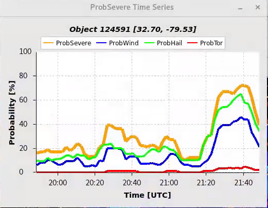
After it moved offshore, GLM FED increased, slightly in advance of a jump in MESH and associated jump in ProbSevere v3. ProbSevere v2 jumped ahead of v3 in probabilities as often occurs, though at that time MESH around 0.9 inches may have warranted the more conservative ~50-60% v3 approach. Later MESH jumped up to around 1.3 inches, and ProbSevere v3 jumped above 70 percent at this time as well.


– Barry Allen