Note that the event occurred across 00 UTC, but we’ll label the summary on the starting date of operations…
We had several tornadic supercells in Central OK today. The first storm developed just west of Norman and noved over the eastern side of the OKC metro, producing a weak tornado. Two other storms developed north, and at least one of these produced a signficant tornado near Ralston.
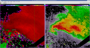
Our visitors, Dave, Mike C., and Andy, worked a PAR IOP today with Pam and Les. Here is an image of the OKC supercell at the time it produced an F0 tornado:
Mike M. also worked a gridded warning IOP on the same storm, concentrating mostly on tornado threat areas. Our IOP lasted about 3 hours, after some gridded warning software issues delayed our start by 1 hour.
MM and I discussed the possibility of another type of warning team concept…use the NWS forecaster as the radar analyst, on the AWIPS machine, and making the decisions of warn, where, and the attributes, and let someone with better proficiency with WDSSII (perhaps an NSSL person) draw the contours. Something for us to think about in future weeks with the experiment, since the WDSSII knobology is a challenge for the visitors.
Greg Stumpf (EWP Weekly Coordinator, 28 April – 2 May)

