
Yesterday, I discussed a problem that forecasters often have which researchers may be less aware of on a day-to-day basis: the sheer amount of change that can occur within a short time span in the atmosphere. To complement that perspective, today I’ll discuss a challenge that researchers often face which forecasters may not deal with as often: the detective work and complexity of eradicating code bugs.
Author: Burkely Twiest
The Difference a Day Can Make
The Spring Forecasting Experiments all share the common goal of fostering communication between the research and forecasting communities, allowing each community to learn from the other. The past few days have provided an excellent lesson that, as a researcher, I sometimes forget. A day can make a world of difference when it comes to a forecast. Operational forecasters are no doubt shaking their head with the obviousness of this statement, but experiencing it firsthand gives me, and perhaps other researchers, a new appreciation for how quickly a forecast scenario can change. I’ll give two quick examples from this week that illustrate this lesson.
9 May 2016
9 May 2016 turned out to be an extremely active day for severe convection, with tornado, wind, and hail reports stretching from Iowa and Nebraska south to the Texas/Oklahoma border. As of this writing, 25 tornadoes were reported. This count may fluctuate, as damage assessment is ongoing. The system that spawned this outbreak continues to cross the United States today, with 16 tornado reports occurring as of this writing. This system will likely warrant further study down the line, but I’d like to give a brief overview of our forecast considerations, review the experimental forecasts we issued yesterday in light of today’s verification, and discuss our evaluation of the forecasts.
Evaluating Nulls
Today was quite an active severe weather day locally. Our thoughts are with the people and families affected by today’s tornadoes. However, today’s SFE forecasts won’t be evaluated until tomorrow, and today’s evaluations focused on the relatively lackluster severe weather across Utah on Friday. Our participants were faced with a problem that has been discussed by the forecast evaluation community for years – how do you rate and compare correct null forecasts?
Question of the week: What do we do with these isochrones?
Week 1 of SFE 2016 is in the books, and overall it was a very successful first week. We had a great group of participants, who gave us good feedback despite the relatively marginal nature of the weather last week. Our domains focused on the eastern and southeastern United States, but we did have one day of forecasting in the west and some long-range south central plains forecasting towards the end of the week. Verification of these forecasts will commence tomorrow and, considering that Norman is in a tornado watch as I type this (~00Z 8 May 2016), we should have some weather to talk about tomorrow. At the end of each week, I’m going to discuss a question we explored throughout the week. This week, we’ll talk about drawing isocrones, lines highlighting the four-hour period of highest risk for any given point. Read more »
Go West!
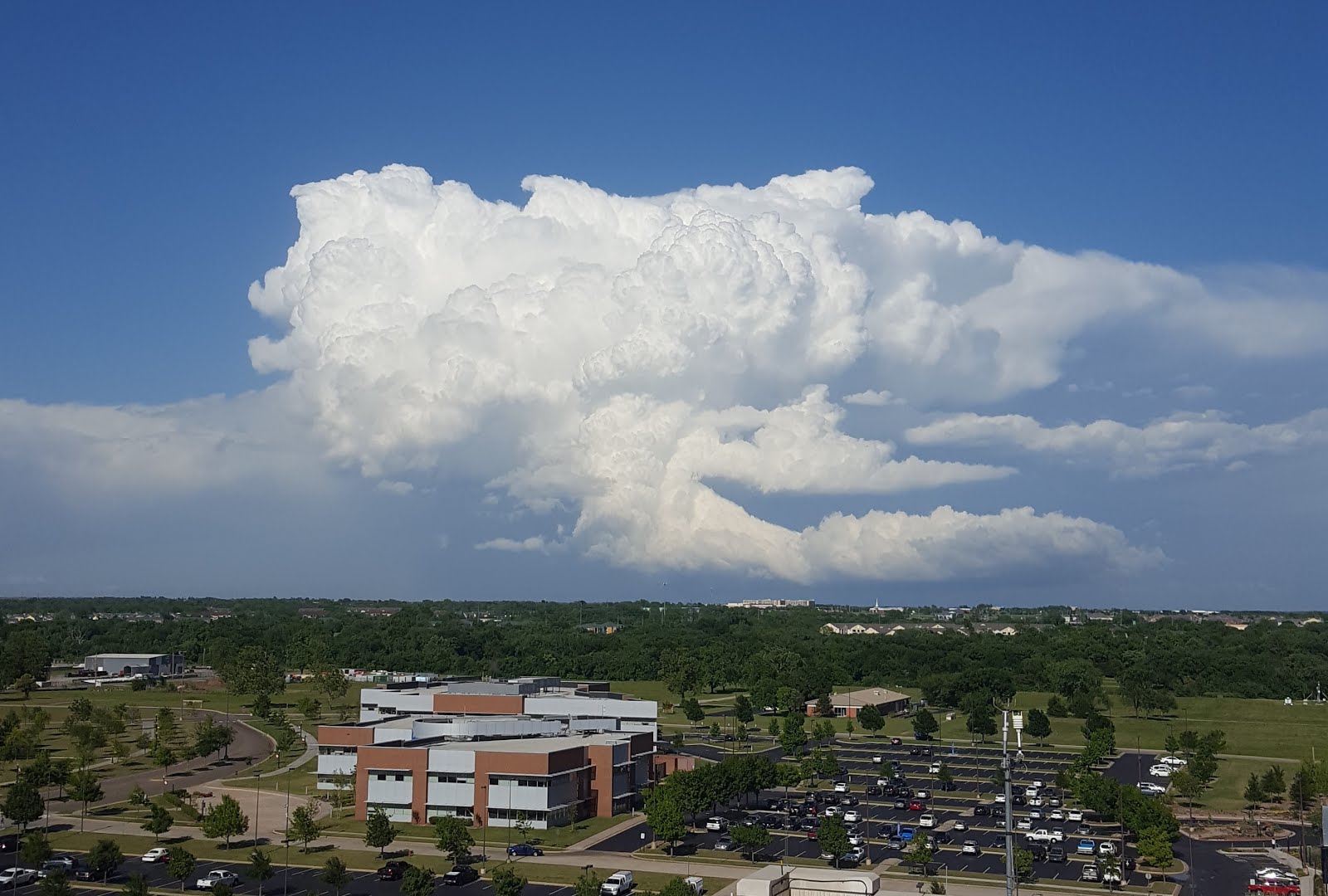
Today, for the first time in the history of the Spring Forecasting Experiment, our domain was west of the Rockies, roughly where the SPC has a marginal risk across Oregon. In prior experiments, computational limitations often prevented extending the domain of the ensembles across the entire contiguous United States. As the eastern two-thirds of the country is climatologically more favorable to severe convective weather, typically the domains would exclude the area west of the Rockies.
Forecasting today was quite interesting. The deep-layer shear was oriented such that storms were expected to move mostly south to north, and terrain was a larger consideration than it normally is. There is a highly detailed topography map that we can have up while issuing forecasts, and terrain features guided the placement of some of our probabilities. Terrain can help initiate storms by providing a source of heating at a high elevation, where the surrounding air is typically cooler than it would be at a lower elevation. Low dew points are a common concern in the west and today was no exception – large areas of high instability were be difficult to come by. However, convection was ongoing this morning, suggesting that some instability was present and taking advantage of the strong dynamic forcing over our area of interest to generate storms.
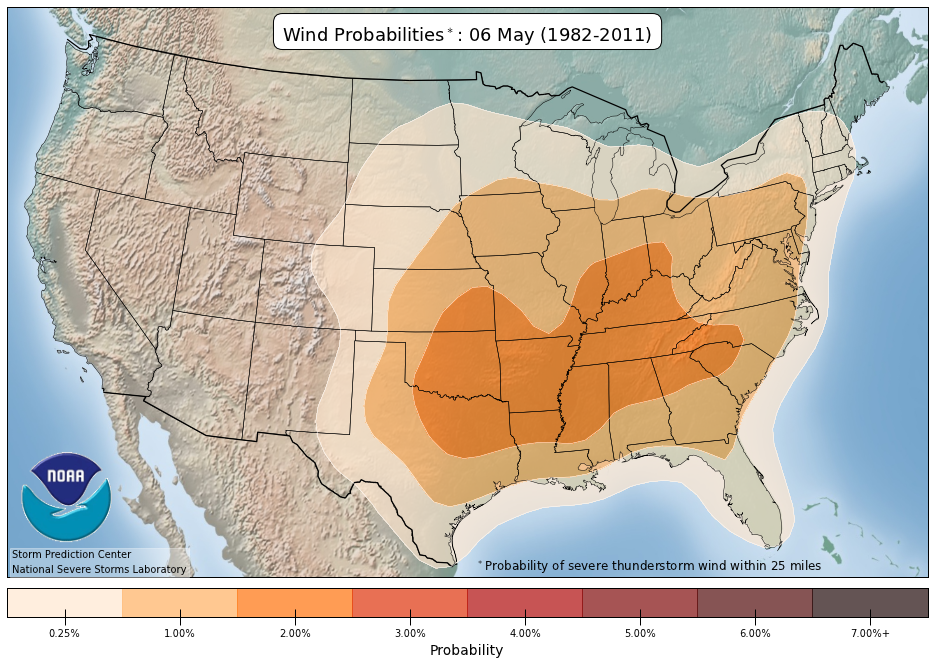
But how climatologically unusual is a severe event west of the Rockies in early May, particularly as far north as Oregon? To begin to answer this question, we can consider the severe climatology maps produced by the SPC on 6 May.
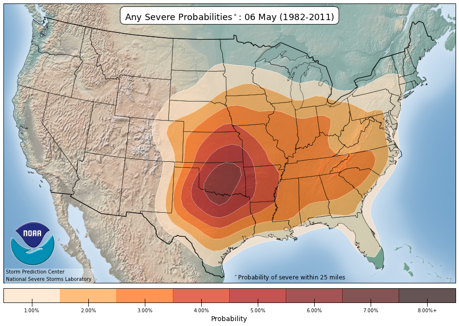
From these maps, we can see that the climatological probability of any severe hazard is extremely low to the west of the Great Plains, not even exceeding 1%. The individual hazard probabilities tell a similar tale:
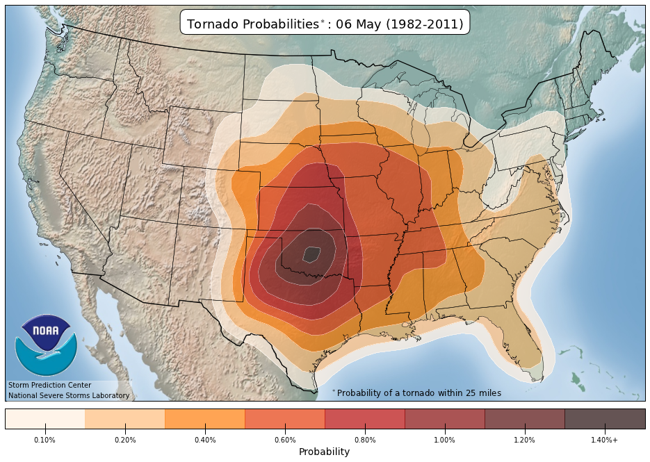
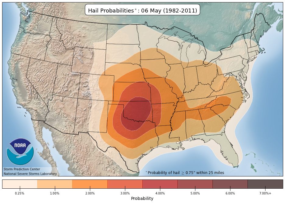
Each of these hazards has less than a .25% occurrence climatologically, according to the reports from this day across a 30-year period.
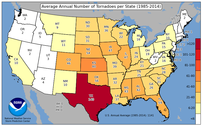
So, when is the most favorable time for severe weather across this region? According to this data set, there really isn’t a discernible peak in tornado reports. With a 30-year average of 5 annual tornadoes in Idaho and 2 annual tornadoes in Oregon, a lack of climatological probabilities isn’t too surprising. However, both hail and wind probabilities remain below.25% until July.
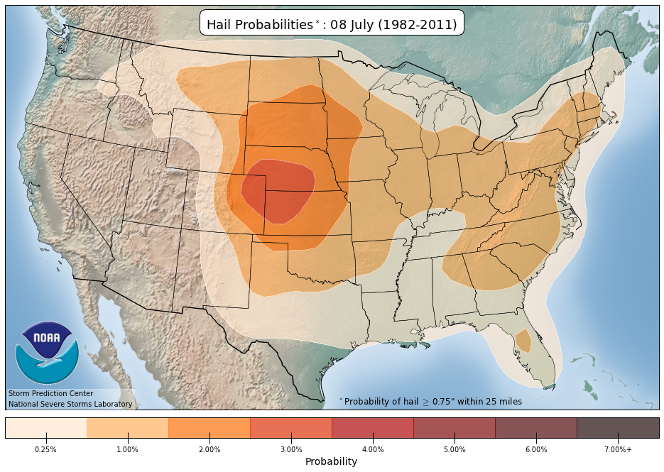
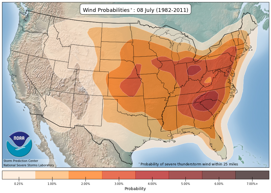
According to these probabilities, it’s unsurprising that the Spring Forecasting Experiment has never gone this far west before or that domain-limited convection-allowing guidance was focused on the eastern two-thirds of the United States.
As of ~0400 UTC a couple of hail reports have come in from Oregon, and they have occurred since 0000 UTC. Storms appear to be ongoing, although radar coverage in mountainous terrain is spottier than elsewhere due to beam blockage. Tomorrow’s verification should have some good discussion about the quality of our westernmost area of interest yet, including how well the convection-allowing guidance performed in a relatively new region.
To Split or Not to Split – that was the question
Yesterday’s area of forecast interest was the southeastern United States, corresponding with an upper-level trough and the warm sector ahead of the cold front. Since our first Day 2 forecast was issued for Tuesday, today (Wednesday) was the first day that we could evaluate a Day 2 forecast and see how we did. We also verified our Day 1 forecast for Tuesday. This forecast was a tricky one, as we weren’t sure how much severe weather the line of convection would produce.
A Tale of Two Desks: Forecast Edition
During SFE 2016, participants complete a variety of forecast and verification exercises. While some of each day is spent as one large group, such as during the morning hand-analysis of maps and the map discussion, the remainder of the day has participants split into two desks. Each desk has a different focus when issuing forecasts, and completes a different set of daily verification exercises. However, participants rotate between desks throughout the week, ensuring that they get to experience all of the activities SFE 2016 has to offer.