High TORP Signal with Strange DivShear

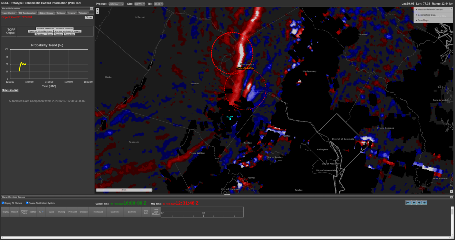
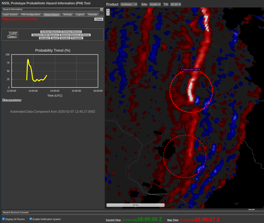
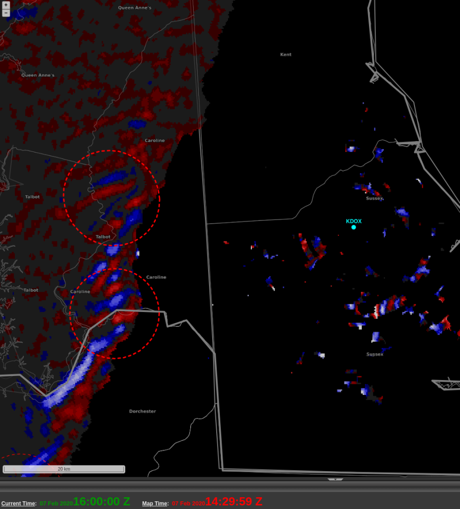
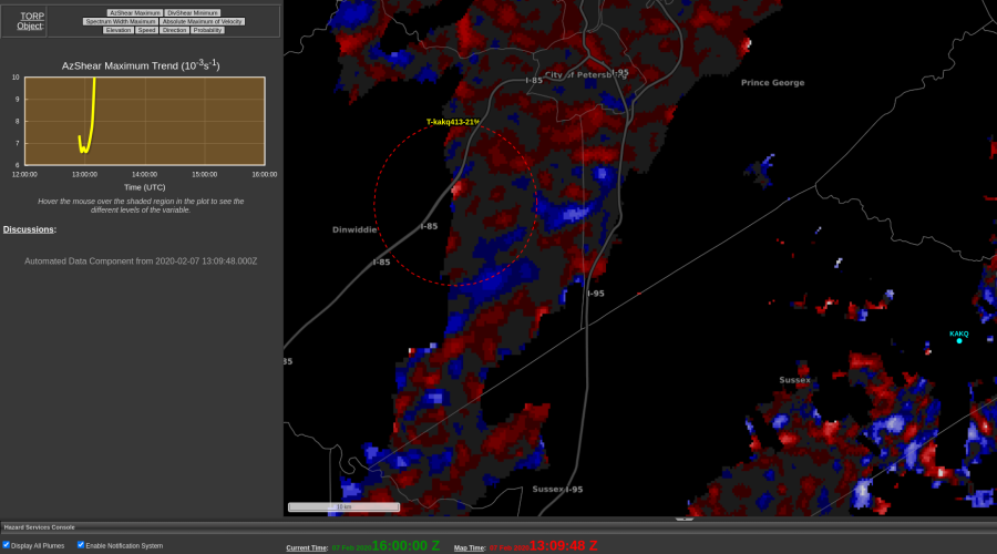
In my pursuit to find strange cases with TORP, AzShear, and DivShear, I stumbled across a large number of single digit TORP probability values along a line of meager convection. As I cycled through the different TORP objects, most looked to have short life spans with low values (as expected) but one looked to extend out over an hour back with sharp spikes in probability up to 74%.

High probability TORP object overlaid on AzShear created by questionable velocity data. Notice the spiky trend line of this object peaking at this timestep.

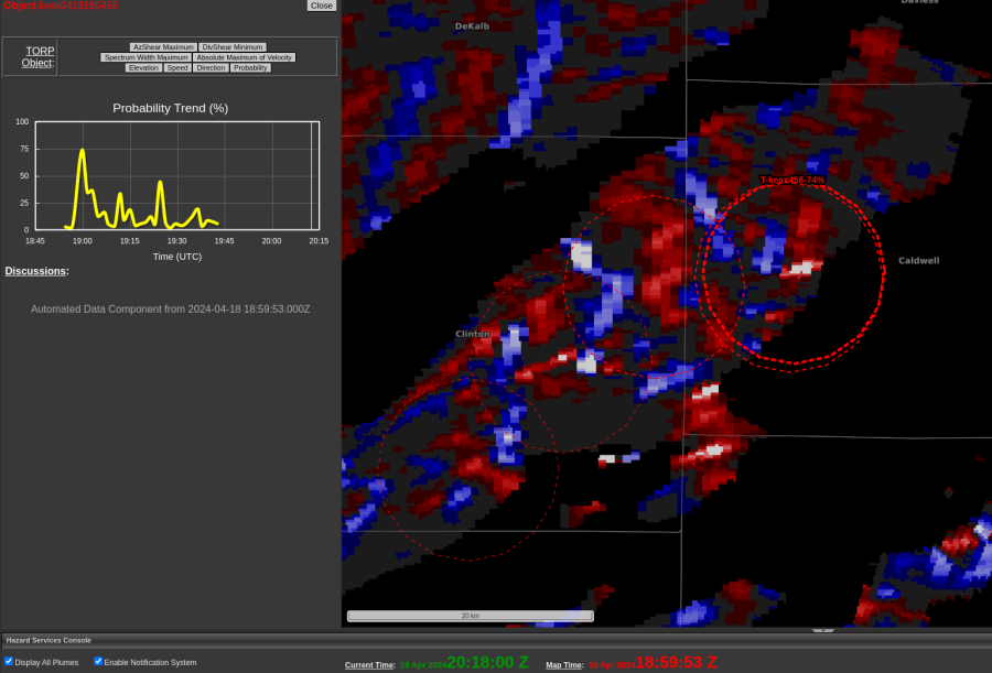
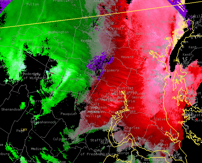
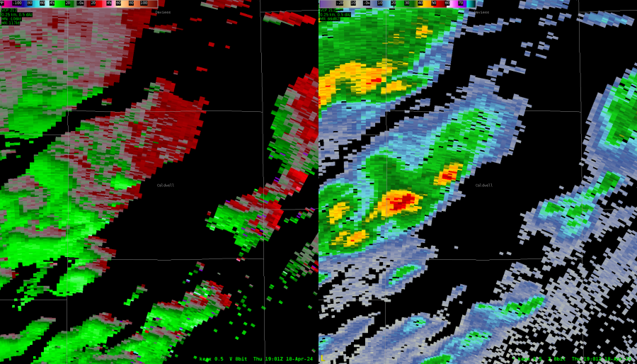
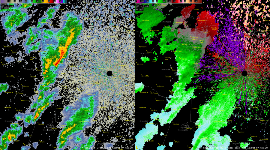
Intrigued, I stepped back to interrogate the storm data, expecting to see a possible tornado in its wake. In reality, it seemingly caused by erroneous velocity data (displayed with reflectivity below).

Meager line of convection at 1901z with erroneous velocity data creating a “decent” couplet.

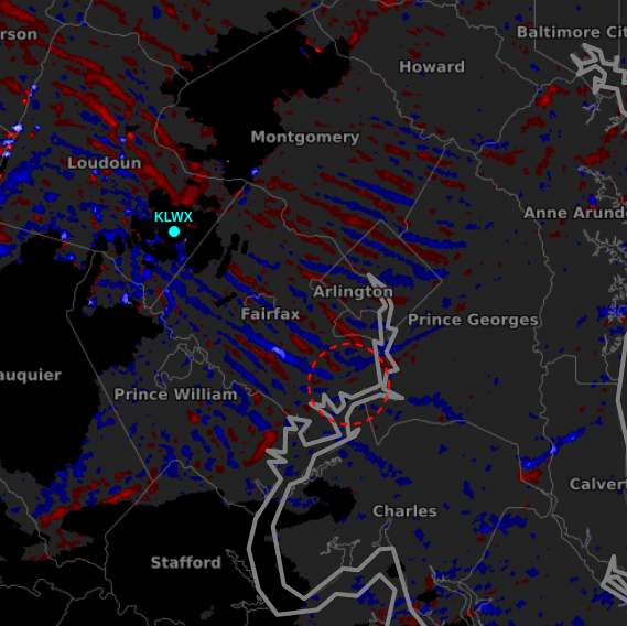
This was a little disappointing both because TORP seemed to have done alright with the line otherwise and this feels like something QC could catch and delete (not that I would necessarily know how). The overdone AzShear looks to explain this outlying detection, but I figured it would be worth also checking DivShear now that we had access to it. What I found was not what I was expecting.

Ribbons of DivShear data with the erroneously high prob TORP object.

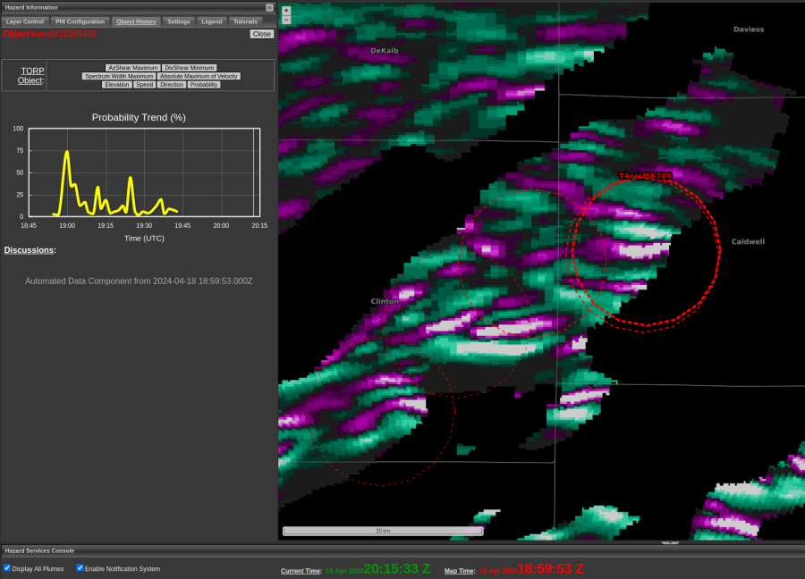
When we have good data for a robust supercell, we would expect a sort of clover formation centered about the max AzShear couplet. Instead we have these long ribbons and convergent and divergent signatures. Pleasing to the eyes, but again not what we want to see if we expect a tornado touching down.

-Wx Warlock

TORP/AzShear for Sidelobe Event

A case of sidelobe contaminated velocity fields occurred around 1945 UTC (Thursday) in Ralls County, Missouri. TORP/AzShear algorithms were quick to initiate an object and jump towards near certain (>90%) values. The object remained for multiple volume scans until sidelobes disappeared. When “real” velocities emerged, TORP magnitudes dropped/went below threshold quickly.  -QLCS

QLCS Orientation Vs. Radar and AzShear Patterns

A short observation. Looking at an incoming QLCS line from KDOX creates two different regimes of AzShear patterns depending upon how parallel to the radial it’s aligned.  We see groups of couplets on the more perpendicular side and a long stretch of convergence/divergence paired on the parallel side.

Meanwhile, TORP still isn’t really sure how to handle this…

-Wx Warlock

Lots o’ Detections

KDOX radar plotted nine TORP detections along a line of low-topped convection at 1451Z on 7 Feb 2020. Eight of the nine detections had probabilities over 30 percent, but almost all of them were less than half an hour in duration.

Posted by Rigel

Strange TORP Object Location Near Radar

Found a questionable TORP object while skimming through a case this afternoon. A few broken lines of convection are approaching the KAKQ radar on an early February morning. I had yet to see many TORP objects as the case is a bit of a slow start, but suddenly noticed this pop up centering on the west side of an oncoming line.

Indication of TORP on the west side of the convective line suspiciously pinging along I-85.

I found this strange, as I not would expect AzShear values to hug that close to the west side of a line. So I went to investigate with reflectivity and velocity data and didn’t find anything I was impressed with.

A normal looking convective line approaches KAKQ.

What I did see, is that the TORP object is centered about a section of I-85 in a section of fairly low reflectivity. In my home office, we’ve seen cars and boats via radar and this could be a similar event, but with a convective line in the way there’s no real way to be sure.

-Wx Warlock

Shorter TORP Timescales on QLCS Case

Most of the TORP objects in this case had very short timescales. This is an example from a tornadic mesovortex where TORP did pick up higher probabilities, but just for a short time. This is largely due to the nature of the storm mode as QLCS tornadoes (and QLCS signatures in general) are quicker and more transient in nature. In previous cases with supercells, the timescale is usually longer.

-Stormy Surge

AzShear Increase with Clutter

Just south of the couplet that did produce damage, AzShear looked quite good with what appears to be clutter near the radar. No damage reports were noted in this area. 
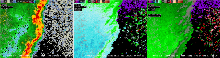
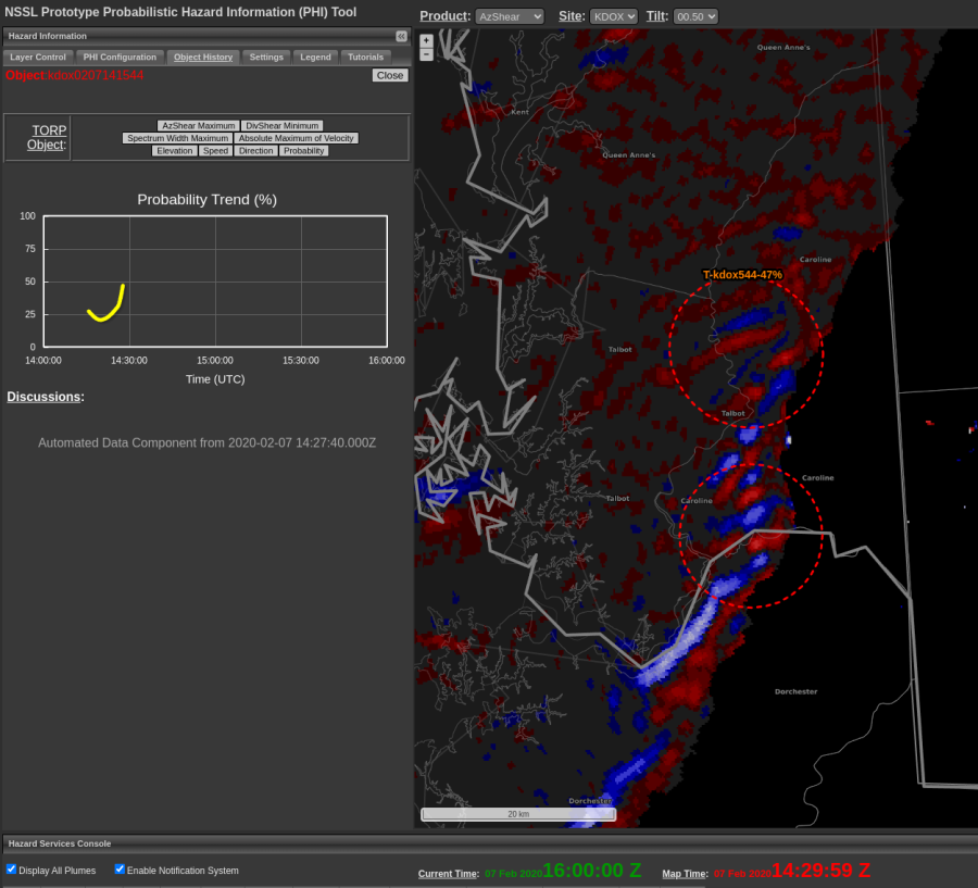
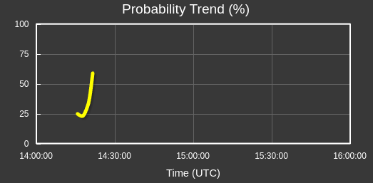
TORP wasn’t that interested in this feature, which is good, but the AzShear certainly caught the eye. This is important to identify as a forecaster and use TORP in tandem with AzShear so as to not be tricked by clutter near the radar that causes AzShear to spike. -newt

Waves

Interesting wave like structure behind the front in an area of relatively steady (light) precip with a TORP object on leading edge (30ish) prob. Wind report closer to the front at 1417Z that has  a weak rotation and signal in AZshear, but does not have a TORP object. – Wildcat

TORP Performance for QLCS Case(s)

As has been noted, TORP lead time is nearly non-existent when it comes to QLCS events. This is especially true when applying a threshold filter >40-50%. However, in this case and others assessed so far this week, FAR with TORP is relatively low for even these marginal/transient cases. The example above displays nearly zero lead time to confirmed event (~1244 UTC), though would be eye-catching should a TOR warning not yet be in place.  -QLCS